SCHIZO-ODOLOGY ON HIGHWAY 90 – The Dead Sea Digital Glitches Project Highway 90 | Digital images | 2015
Hebrew follows English עברית אחרי אנגלית
Highway 90
Israeli Highway 90, the longest highway in Israel – 478 km – operates as the country's backbone, extending from the northern border with Lebanon to the southern border with Egypt, and parallel to the Israel-Jordan border to its east. About 360 km of that route is a desert: The Arava Desert in the south, the Judean Desert along the Dead Sea, and the Great Rift Desert from the Sea of Galilee to the Dead Sea along the Jordan Valley. A quarter of the route –118 km – runs in the occupied territories of the West Bank. This means that a notable segment of the route along the Dead Sea is part of the West Bank and thus is a controversial, contested territory. Highway 90 is a political-ideological linear space whose functionality addresses contested territorial borders while blurring them within its breathtaking sublime landscapes. The landscapes of Highway 90 form an ambiguity that disguises and veils the power systems that operate and constitute it.
Desert and speed The political-ideological mode of the highway is realized while on a fast drive, reluctantly forming a cinematization of the landscape while the gaze flattens the rapidly passing sublime landscape, forming it into animated images. Theoretician Paul Virilio associates the desert with awe, terror, and the desire for acceleration and velocity: "The desert is desire, desire for a body of absolute speed" (Virilio 2008, 131). The landscape then becomes a distorted reflection projected onto the windshield (Virilio 2002, 2006, 2008). Speed and acceleration operate as a political practice in the landscape. The speed that distorts reality becomes an aesthetic measure but no less a political one. Velocity and viewing operate as means of forming the self and the national. Thus, the subject's desire to materialize it through fast drive is reassured and empowered by the nationalistic-territorial desire of the highway landscape.
Schizoanalysis and Odology Schizoanalysis is a concept coined by the philosophers Gilles Deleuze and Felix Guattari. An intellectual point of view that seeks to indicate the possibility of multiplicity and the options of examining it in moves or directions that are not absolute or predetermined. Schizoanalysis defies Freudian psychoanalytic thought and its determinations concerning the structure of the unconscious and of the mind in general while offering a complex rhizomatic and subjective mode of the subject. In doing so, Deleuze and Guattari created a new philosophical approach that provides an examination and conceptualization that is reluctant to representations and interpretation, rather an inquiry of Becoming (Deleuze and Guattari 1987). Odology is commonly known as the study of pathways and roads. Its origins are in the Greek word hodos meaning road or journey. However, this concept is used in other research fields, such as mathematics, geography, psychology, and philosophy. Conservative Odology deals with the technology of roads, infrastructures, and transportation systems, as well as with engineering, safety, environmental and economic contexts. As such, it traditionally lacks a critical perspective. The concept of Odology in landscape and spatial context was addressed by culture geographer J.B. Jackson (Jackson 1984, 21), who sought to expand the field of Odology, interpreting cultural, political, and social facets of roads, highways, and transportation systems. Schizoanalysis and Odology here as a mode of becoming, suggesting a new perception of the landscape. Schizo-odology is therefore, a critical-theoretical and artistic interdisciplinary exploration in which both art and critical thinking serve to explore new ideas and perceptions of landscape and space. Deleuze and Guattari stress that Becoming is a schizoid process. "The image is not only a trajectory but also a becoming" (Deleuze 1997, 65). This project offers observations on the landscape as Becoming, meaning being in a constant course of change. The work of the Digital Glitches dwells on our observation of the landscape while driving, which is on a continuous mode of becoming. The Digital Glitches form an artistic move in digital cyberspace, in between virtual and reality. The landscape that we observe
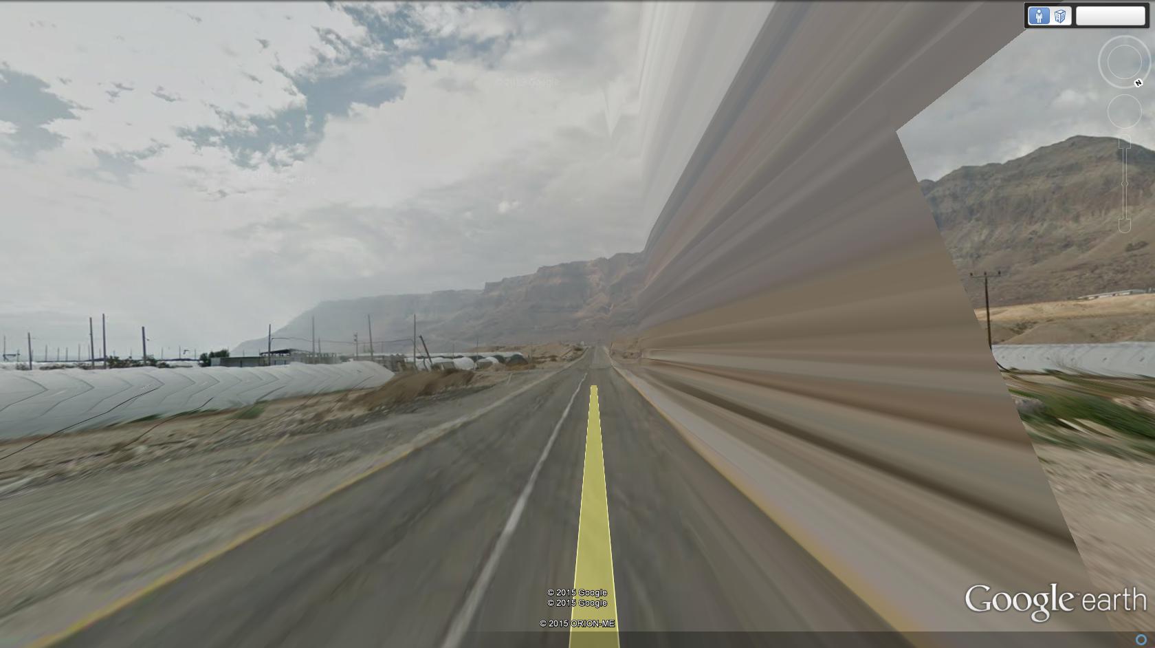
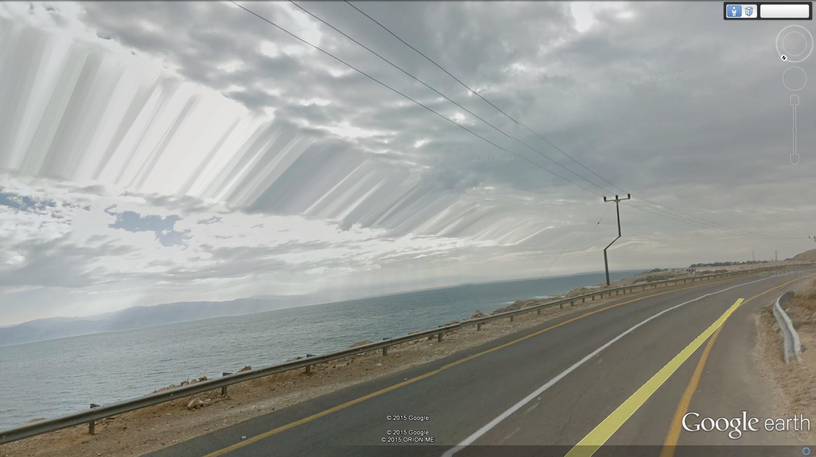
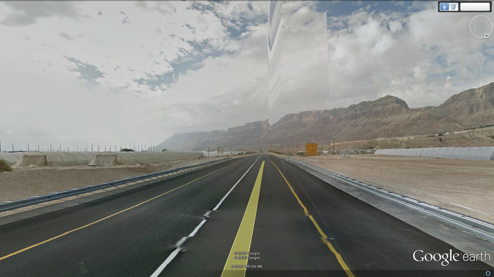
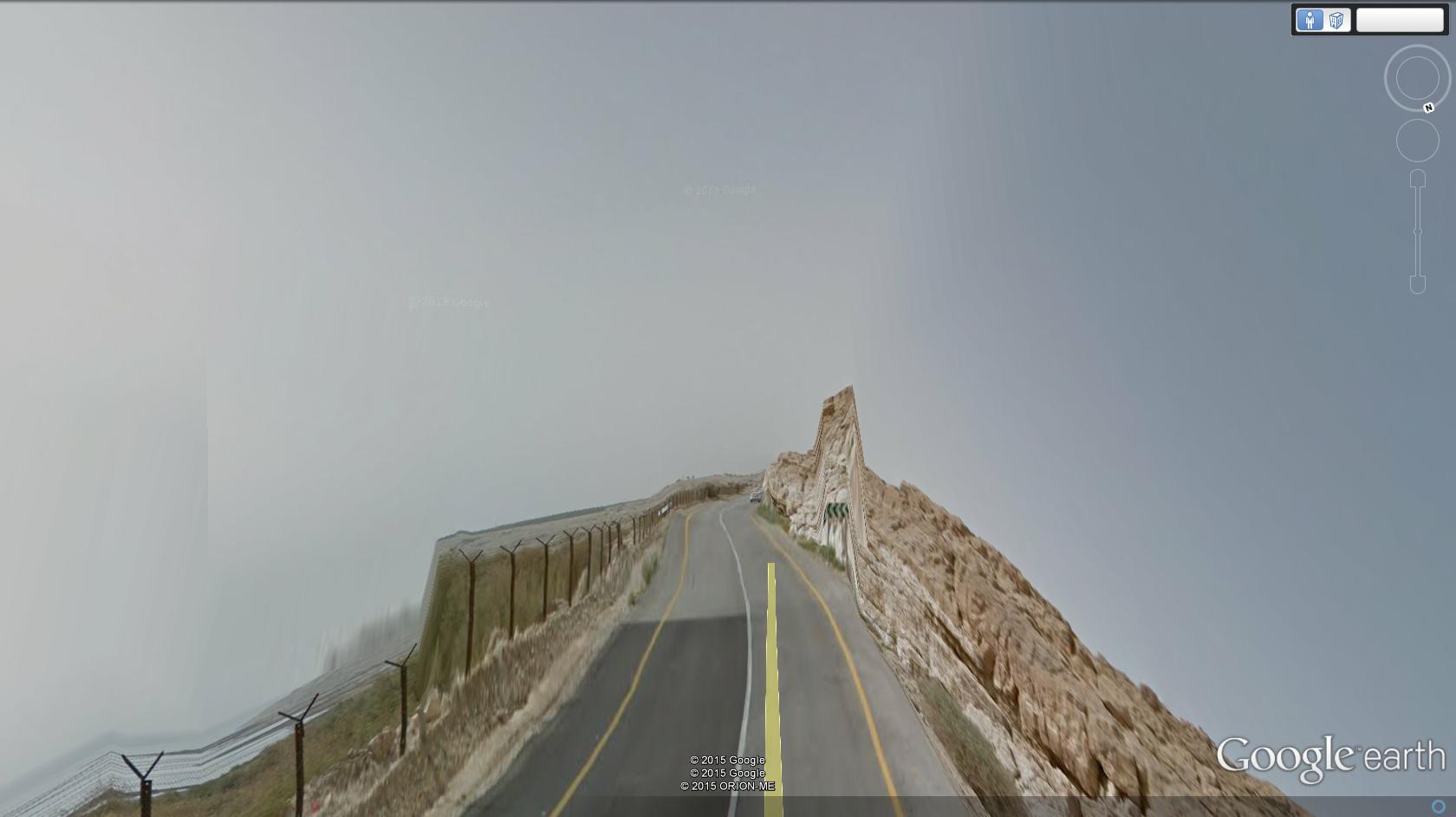
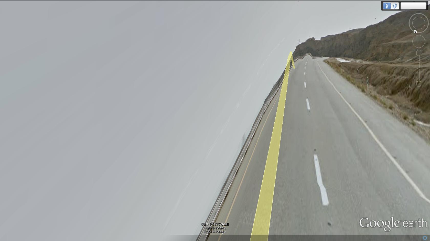
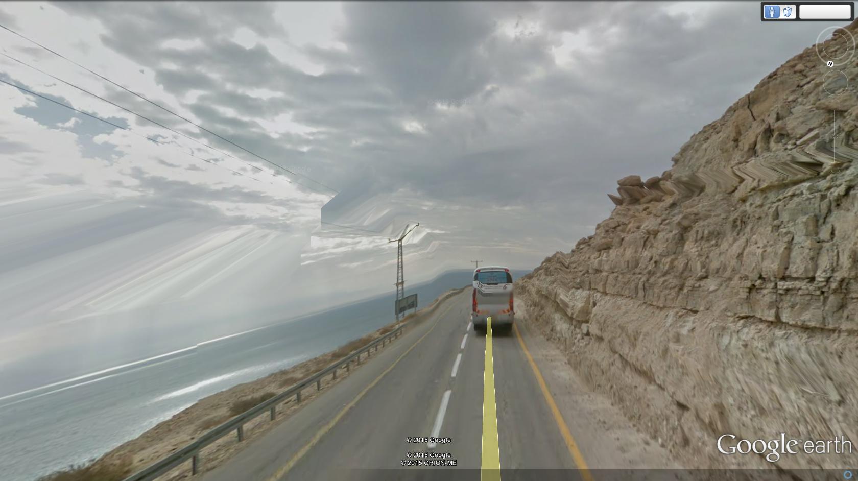
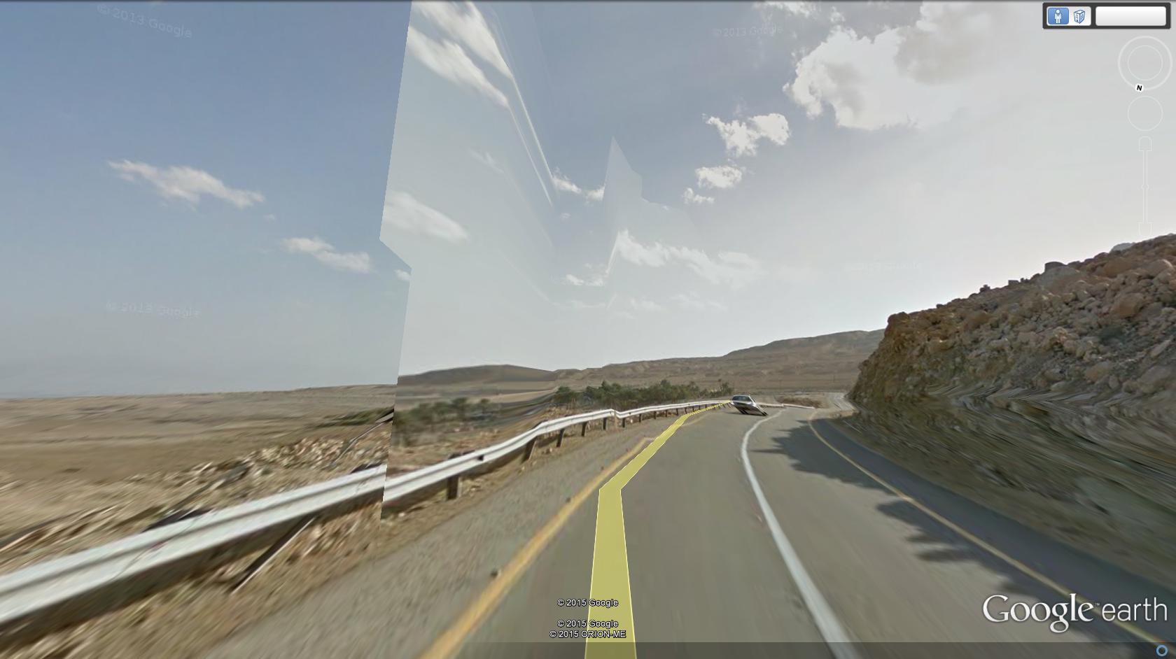
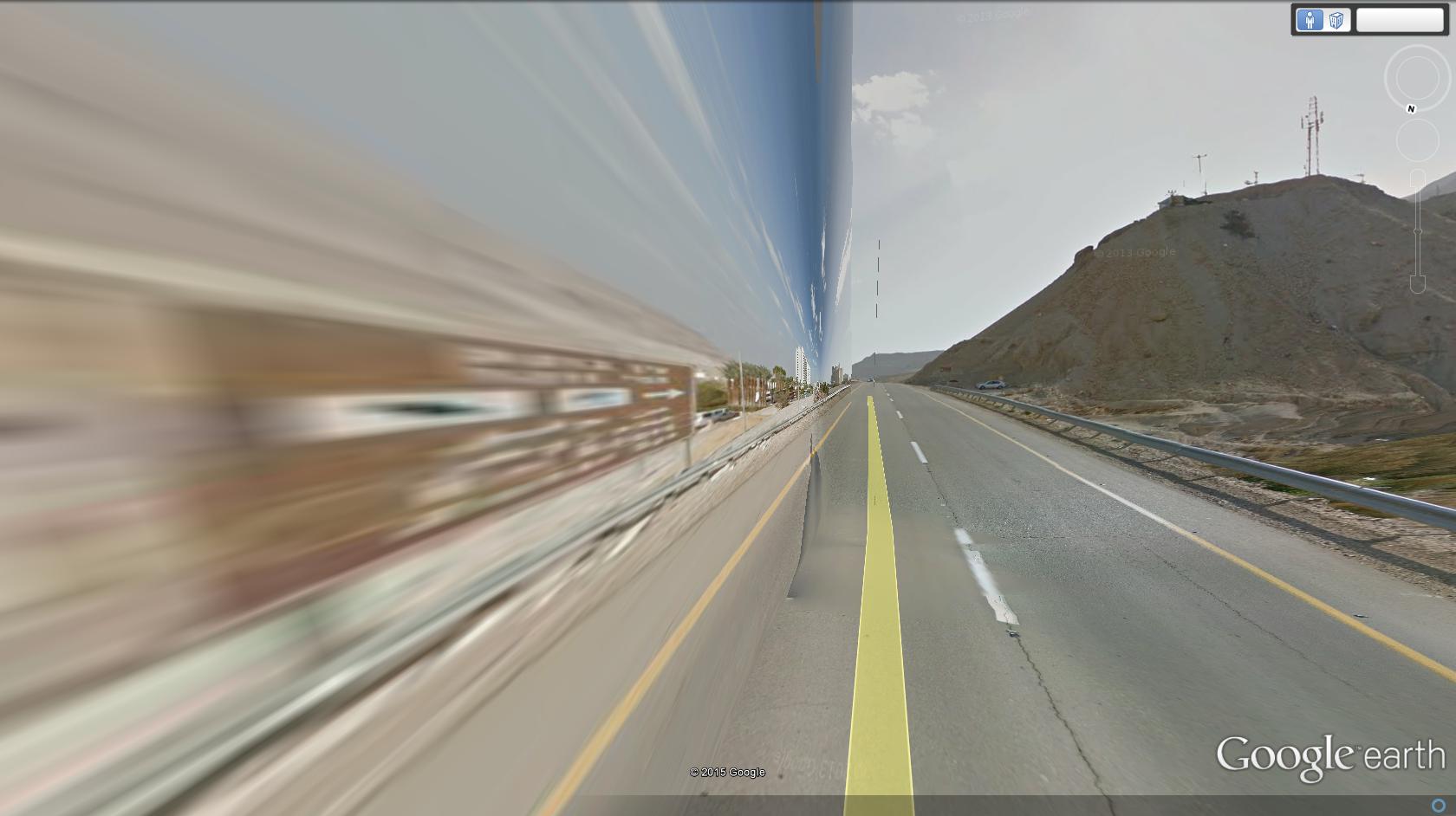
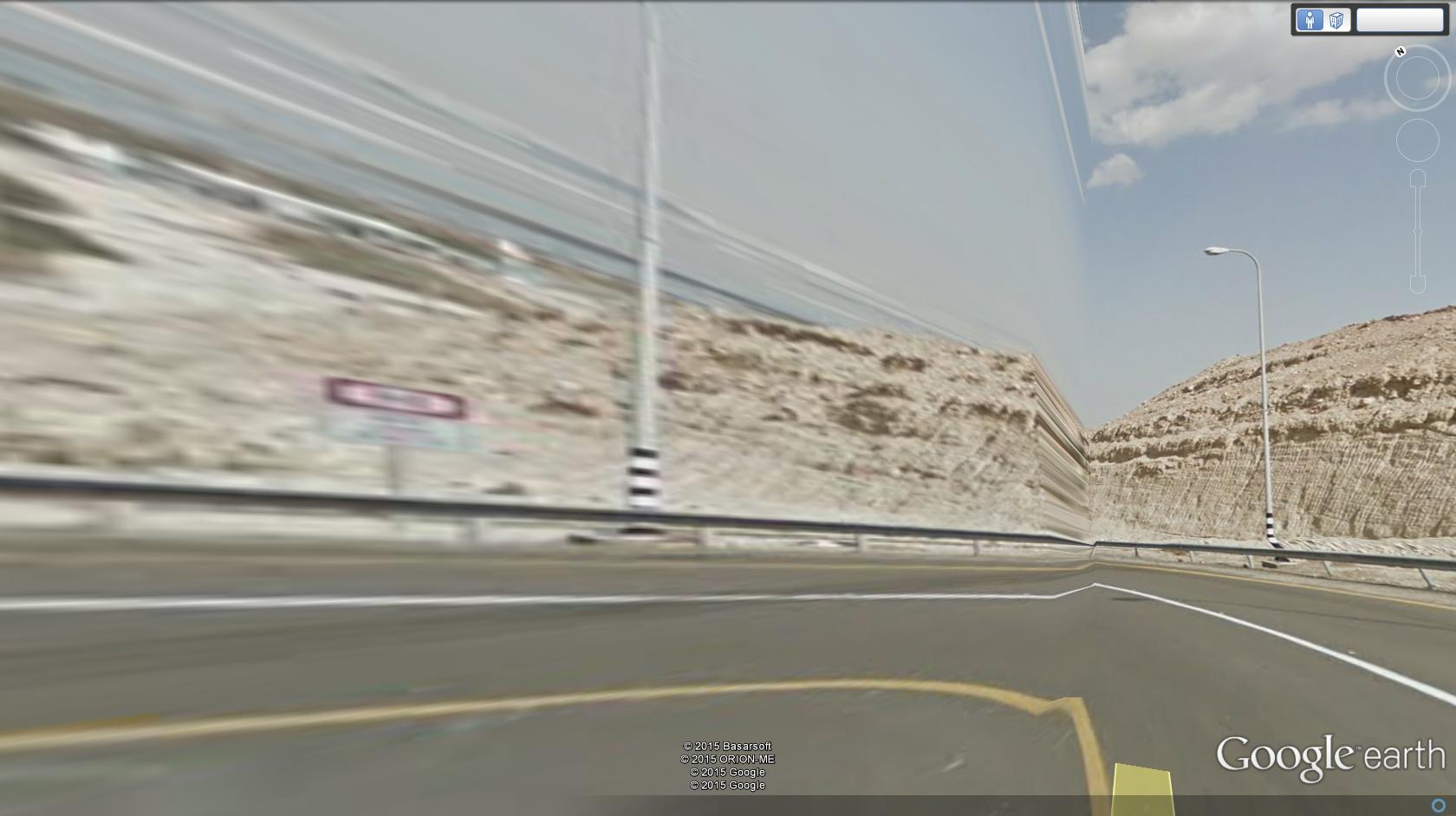
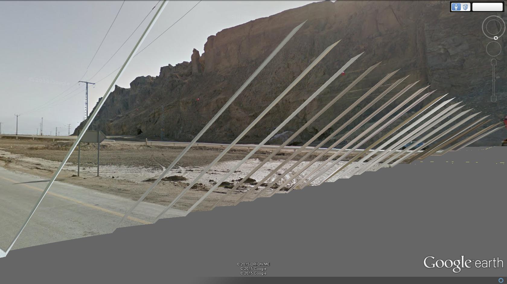
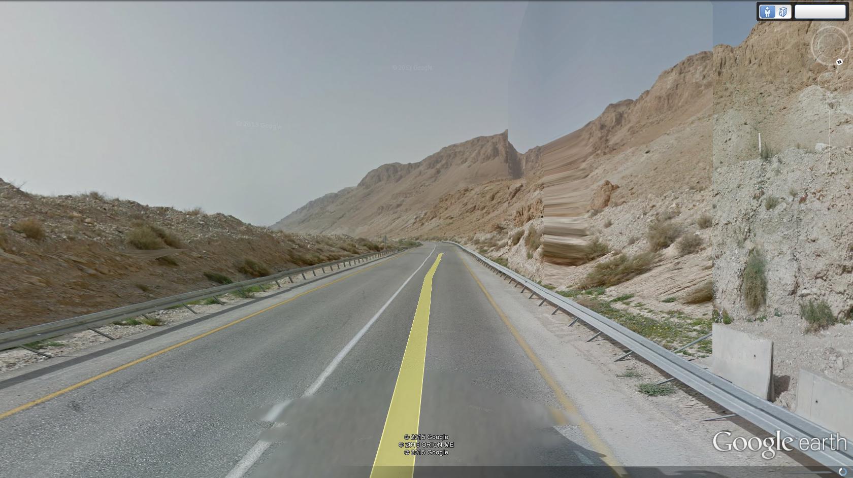
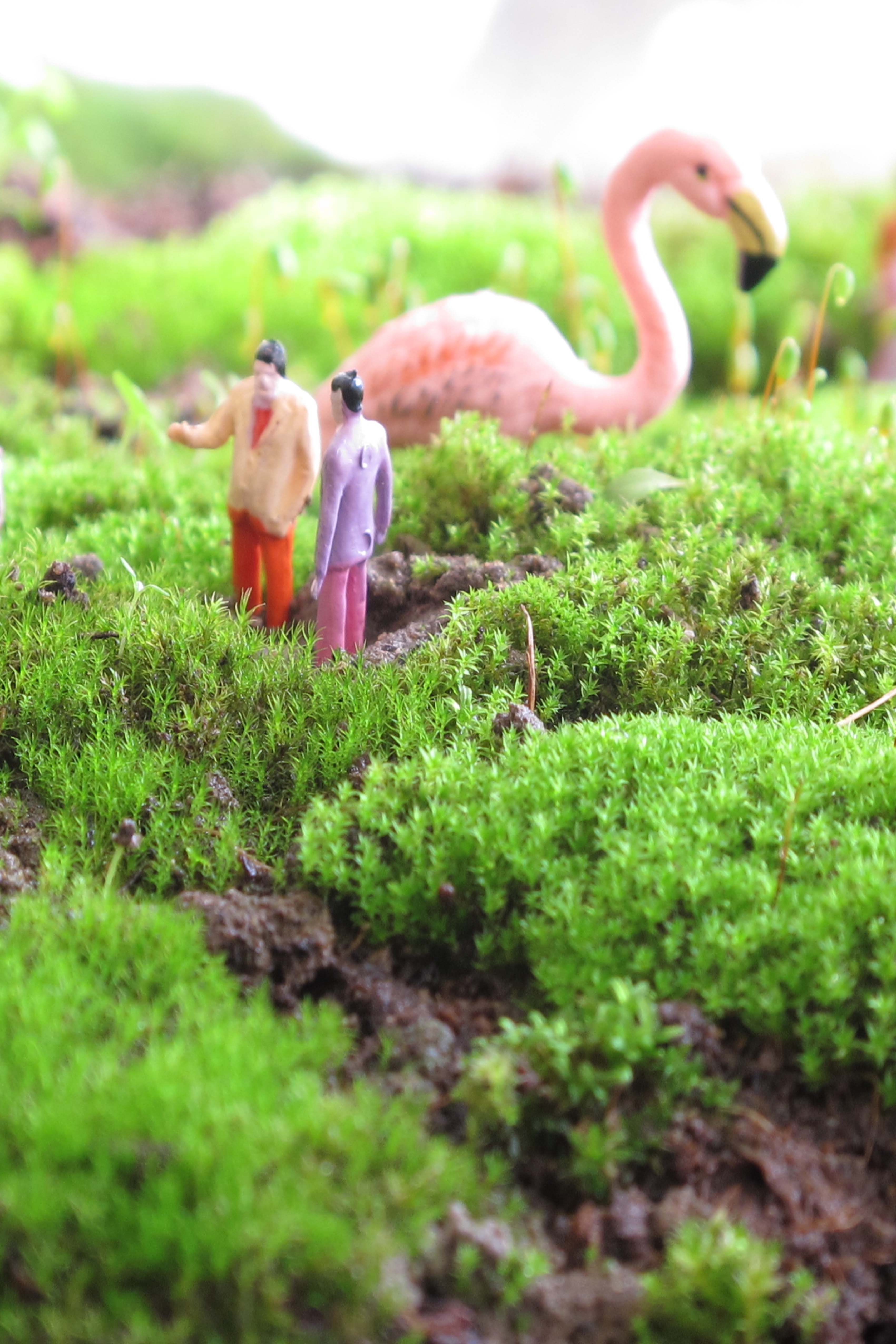
The Digital Glitches The project Schizo-odology on Highway 90 is a series of digital images of digital glitches. The glitches' works are the outcome of deliberate disruption, digital distortion of visual information. In the glitches works, I form new landscapes while disrupting the existing ones, distorting and violating them and their familiar form. The glitches convey double acceleration of the virtual space: an external acceleration that is part of the fast travel movement and an internal acceleration of parts of the virtual space that do not accord with the speed of other segments of the same digital space. The collapse of the virtual representation system then becomes the collapse of the space and landscape themselves. In this manner, I seek to undermine the perception of familiar landscapes and to unfold the ideology that constitutes them. The project Schizo-odology on Highway 90 suggests a rhizomatic perception of space, conveying the formation of new spaces and paths within it. They constitute a new space, simultaneously alienated and familiar. The Schizo-odology works of highway 90 fold the space, interrupt and break the familiar and the known while removing parts of it and distorting and disrupting other parts, doubling, flattening, slicing, or stretching it. The glitches make the space vibrate, tremble, fluid and unstable. In other places, the nearby landscape remains stable, but the distant surroundings, the mountains, and the sky go wrong, collapsing within themselves. The sublime of the desert is thus revealed as an uncanny space, threatening, elusive, yet real and present.
The images here are from the Dead Sea Road series.
כביש מס. 90, בין מטולה לאילת הוא הכביש הארוך בישראל, נמתח לאורך כ-478 קילומטרים המתמשכים במקביל לתוואי הגבול המזרחי של ישראל. כביש 90 מחבר גם בין גבול ישראל-לבנון בצפון וגבול ישראל-מצרים שבטאבה, וחוצה פעמיים את גבול הקו הירוק בעוברו לאורך הגדה המערבית. שלושה רבעים מהדרך (360 ק"מ) הם מדבר.
כביש 90 הוא מרחב פוליטי-אידיאולוגי, מגדיר גבולות טריטוריאליים שחלקם שנויים במחלוקת ומתעתע בפונקציונליות שלו ובנופיו הנשגבים. נוף מרחב הכביש מייצר אשליה ומראית העין שמסווים ומטשטשים את מערכות הכוח הפועלות בו, ומכוננות אותו.
החזון הפוליטי-אידיאולוגי של הכביש מתממש בעת נסיעה מהירה המייצרת סינמטיזציה של הנוף כאשר המבט משוטח לכדי תמונת נוף נשגבת, חולפת במהירות. המדבר נקשר בשגב ואימה ובתשוקה להאצה ולמהירות גבוהה: "The desert is desire, desire for a body of absolute speed" (Virilio 2008, 131). הנוף נעשה השתקפות מעוותת המוקרנת על השמשה הקדמית (Virilio 2002, 2006, 2008). מהירות והאצה הופכות לפרקטיקות פוליטיות המתקיימות בנוף. המהירות שמעוותת את המציאות הופכת לאמצעי אסתטי אך לא פחות מכך לאמצעי פוליטי. המהירות והמבט הם אמצעי לכינון העצמי והלאומי ותשוקת היחיד למימוש האיווי באמצעות נסיעה מהירה נקשרת בתשוקה הלאום למימוש לאומיותו.
הפרויקט סכיזואודולוגיה בכביש 90 הוא סדרת צילומים דיגיטליים. עבודות גליצ' שהן תוצר של שיבוש מכוון, עיקום מידע דיגיטלי ויזואלי. בעבודות הגליצ' אני מייצרת נופים חדשים, משבשת את הנוף הקיים, מעוותת אותו ומפרה את הייצוגים המוכרים שלו. בגליצ'ים מתקיימת האצה כפולה במרחב הווירטואלי: האצה חיצונית שהיא חלק מתנועת הנסיעה המהירה והאצה פנימית של חלקים מהמרחב הווירטואלי שאינה מתואמת עם מהירות חלקים אחרים באותו המרחב. קריסת מערך הייצוג הווירטואלי היא גם קריסת המרחב והנוף עצמו. באופן זה אני המבקשת לערער את אופן תפיסת הנופים המוכרים ולחשוף את האידיאולוגיה המכוננת אותם.
הפרויקט סכיזואודולוגיה בכביש 90 עוסק בתפיסה ריזומטית של מרחב, ובאופן בו תפיסה זו מאפשרת התבוננות ויצירת מרחבים ומישרים חדשים בתוכו. סדרת עבודות הגליצ'ים היא דימויים דיגיטליים של מרחב כביש 90 המייצרים מרחב חדש, זר ומוכר כאחד. העבודות סכיזואודולוגיה בכביש 90 מקפלות את המרחב, קוטעות ושוברות את המוכר, מעלימות חלקים ממנו ומעוותות ומשבשות חלקים אחרים, מכפילות, משטיחות, פורסות או מותחות אותו. הגליצ' עושה את המרחב לרוטט, רועד, נוזלי ולא יציב. במקומות אחרים ,הנוף הקרוב נותר יציב אך הסביבה הרחוקה ההרים והשמיים משתבשים, קורסים לתוך עצמם. הנשגב של המדבר מתקבל כמאיים, אלביתי, לא אפשרי ובאותו זמן ממשי וקיים.
בעבודות ישנו שיבוש, עיוות או הפרה חריפה של ייצוג המרחב כפי שאנו מצפים לראותו באמצעות תוכנת google earth וטכנולוגית 'גוגל וויו'. הצילומים הם תוצר של תנועה במרחב הווירטואלי של כביש 90 וביטוי וויזואלי של כשלים באלגוריתם המייצר את דימויי המרחב הווירטואלי. הצילומים שוברים את הרצף המרחבי ולמרות שהמבט בהם הוא לינארי הם משבשים את הפרספקטיבה וקורעים את המסך מעל לפרספקטיבה הקרטזיאנית המוכרת. העבודות מייצרות מרחב וויזואלי חדש שאינו מייצג עוד את הקיים והמוכר. עבודות הגליצ'ים מציעות תפיסה דלזיאנית המבקשת לפרק את המרחב ולא לייצגו אלא ליצור בתוכו ומתוכו. הגליצ'ים הם תוצר ויזואלי של התפיסה הסכיזואנליטית הדלזיאנית באמצעותה אני בוחנת את המרחב והנוף ומייצרת בתוכו מישרים חדשים.
יצירת הגליצ היא מהלך מכוון אך בתוצאה ישנה מידה מסוימת של אקראיות. כמו די.ג'י. שמייצר סאונד חדש מתקליטים קיימים באמצעות החלקת התקליט תחת המחט כך אני נעה הלוך ושוב בין שתי 'תחנות' של דימוי ויזואלי 'נכון'. את הגליצ' אני מייצרת במקום שאיננו קיים בין 'הדימויים הנכונים'.
העבודה נחלקת לשני סוג דימויים היוצרים מציאות וירטואלית חדשה, מקבילה לזו הקיימת: הסוג הראשון יוצר מסות של פיקסלים או פסים, עיוותים של המרחב ושיבוש הפרספקטיבה כמו גם תמונות 'ראי' והכפלות וירטואליות של המרחב שכמובן אינן קיימות במציאות. הסוג השני מייצר חשיפה וויזואלית של הארכיטקטורה הפנימית של התוכנה כשהשיבושים מביאים לצירופים וויזואליים החושפים את 'אחורי הקלעים' שלה. כך נוצרים עיוותים כללים ומציאות וירטואלית חדשה שאינה מייצגת את הקיימת. דוגמא נוספת לשיבוש ויזואלי היא חשיפה של שטחים אפורים, כשל של האלגוריתם המופיע כדימוי רישומי עדין של מערכת קווים ונקודות צבעוניות. בכולם תמיד ישנו הגרעין "האמיתי", כלומר אופן ייצוג "נאמן למציאות" ומולו עומדים העיוותים והמישורים המעוקמים.
הצילומים נעשו במהלך טיול וירטואלי לאורכו של כביש 90 שהוא מרחב לימינאלי פוליטי, תרבותי ונופי של ריבוי ובו נרטיבים מקבילים ומצטלבים, רווי מיתוסים ושבריהם, היסטוריות ומציאות דחוסה בפוליטיקה ואידיאולוגיה. הפרויקט סכיזואודולוגיה בכביש 90 עוסק במקטעים ממרחב כביש 90 ובאמצעות עשייה סכיזואנליטית בוחן את מרחב הכביש ובתוך כך את המרחב בישראל ומעלה שלושה דיונים: הדיון הראשון עוסק בשיח המרחב בישראל ובכביש 90 כמקום שהוא חלק מהמרחב בישראל: אידיאולוגיה ומרחב בכביש 90. דיון זה מעלה את האופן בו מרחב מוכר מתעוות ומופר ובכך פותח אפשרויות תפיסה חדשות של המרחב. הדיון השני קשור בטכנולוגיות יצירה ושיבוש מרחב וירטואלי ובחינת מערכי ייצוג של כביש: עבודה עם תוכנת google earth כמדיום אמנותי. הדיון השלישי עוסק בשאלת חקירת המרחב באופן תיאורטי ביקורתי ויישומה באמצעות אמנות: האם קיימת אפשרות לפרקטיקה אמנותית של חקירת המרחב המבוססת על התיאוריה הסכיזואנליטית של דלז וגואטרי.
במהלך נסיעה 'אמיתית' או 'וירטואלית' המבט מיושר קדימה ו"גולש" בנוחות על צלעות פירמידת הראיה של הפרספקטיבה הלינארית של מרחב הכביש. בגליצ'ים המבט אינו יכול לגלוש בנוחות על צלעות פירמידת הראיה של הפרספקטיבה של מרחב הכביש. העיוותים, המישורים החדשים שנפתחים בצלעות הפירמידה של הפרספקטיבה, הכתמים המרוחים חסרי הפשר, כל אלו מפרים ומשבשים אותה. הגליצ'ים כמו הפרספקטיבות והאנאמורפוזות עסוקים גם הם במה שלא ניתן לראות באחת, בו בזמן. באמצעות העיוות הם מעלים את הגילוי והאבדן של המבט בשדה הסקופי של מרחב הכביש. במצב זה חלקים מהדימוי עוברים קידוד שונה משאר החלקים בדימוי עד שהוא נראה כגוף זר המרחף מעל פני שטח העבודה כמסה המרחפת במישור נפרד במידה מסוימת של דמיון ויזואלי לאופן בו מופיעה הגולגולת כאנאמורפוזה בציור 'השגרירים' של הולביין (Holbein). המקום המשובש בציור הוא המקום המשובש בגליצ' הוא המקום המשובש בנוף. כמו ב'שגרירים' של הולביין, לאותם מישרים חדשים, לאותן מסות מפוקסלות מרחפות יש מעמד של ואניטס. גם בציורי ET IN ARCADIA EGO, יש שיבוש סימבולי בדמות הגולגולת המתגלה ביער בציור של Guercino או הקבר במתגלה בנוף של פוסאן (Poussin). הנוף רוצה להיות פסטורלי ופיטורסקי אך הגליצ' משבש אותו ובשל כך לגליצ' משמעות של ET IN ARCADIA EGO ומעמד של ואניטס. גם הטכנולוגיה, כדוגמת 'גוגל סטריט' רוצה, ממש כמו הנוף, להיות מושלמת. הופעת השיבוש חושפת אזהרה לואניטס טכנולוגי: ET IN TECHNOLOGY EGO.
הגליצ'ים חושפים את חולשת הדימוי השלם של נוף הכביש ומכאן גם את חולשתו של הנוף עצמו. הדימוי הוויזואלי רוצה לייצג את מרחב הכביש המושלם, העגול, הנקי, הלא מופר ולא מופרע, intact space. באמצעות הגליצ'ים אני מייצרת פערים וחושפת חלקים-מישרים של המרחב שאינם מתגלים באופנים אחרים. ההאצה יוצרת באמצעות המבט פערים וחורים של תפיסה. הנוף אינו פסטורלי כפי שהיינו רוצים לתפוס אותו. הוא מסתיר מעוות מטשטש ובכך מהווה בעצמו פרקטיקה.
הדימויים המוצגים כאן לקוחים מתוך סדרת כביש ים המלח.
***
שם הפרויקט: סכיזואודולוגיה בכביש 90 מבוסס על הֶלחם, מושג שטבעתי המורכב משני מושגים: סכיזואנליזה ואודולוגיה.
סכיזואנליזה הוא מושג שפיתחו הפילוסופים דלז וגואטרי כמחשבה אינטלקטואלית המבקשת להצביע על אפשרות הריבוי שבדבר ועל האפשרות לבחון אותו במהלכים או מישרים שאינם מוחלטים או קבועים מראש. הסכיזואנליזה היא קריאת תיגר על התפיסה הפסיכואנליטית הפרוידיאנית ועל וקיבעונותיה ביחס למבנה הלא מודע ומבנה הנפש בכלל והיא מציעה התבוננות מורכבת ריזומטית וייחודית לסובייקט. בתוך כך יצרו דלז וגואטרי גישה פילוסופית חדשה המציעה בחינה של הדברים שאיננה מעמדה של ייצוג ופרשנות הייצוג בלבד אלא באמצעות עשייה והיעשות (Deleuze and Guattari 1987).
אודולוגיה, Odology הוא מחקר ומדעי הדרך אך במושג זה עושים שימוש בשדות מחקר נוספים בהם מתימטיקה גיאוגרפיה פסיכולוגיה ופילוסופיה. אודולוגיה מסורתית עוסקת בטכנולוגיה של דרכים, תשתיות ומערכות תחבורה, ובהקשרים הנדסיים, בטיחותיים, סביבתיים וכלכליים ובדרך כלל כמחקרים נעדרי מבט ביקורתי. את המושג אודולוגיה בהקשר המרחבי טבע חוקר התרבות והמרחב ג'.ב. ג'קסון (Jackson) שביקש להרחיב את שדה האודולוגיה גם לקריאה ופרשנויות תרבותיות, פוליטיות וחברתיות של כבישים, דרכים ומערכות תחבורה.
המושג סכיזואודולוגיה הוא מושג שטבעתי והוא אינו תיאורי אלא מושג של היעשות- becoming. "הריזום הוא חלק מגיאוגרפיה או תורת מרחב חדשה" כותבים אריאלה אזולאי ועדי אופיר (אזולאי ואופיר 2000, 126). המושג סכיזואודולוגיה מציע תפיסת מרחב חדשה. באמצעות הפרויקט סכיזואודולוגיה בכביש 90 בו אמנות משמשת אמצעי חקירה מרחבית אינטרדיסציפלינרית.
דלז וגואטרי עוסקים במהלכים של היעשות becoming כתהליך סכיזואידי והפרויקט מציע התבוננות בנוף ובמערכות ייצוג שלו כנמצא במהלך מתמיד של השתנות: (The image is not only a trajectory, but also a becoming" (Deleuze 1997, 65). עבודות הגליצ'ים, אם כן הם היעשות אמנותית במרחב שבין הווירטואלי והמציאות. גם הנוף בו אנו מתבוננים תוך כדי נסיעה נמצא בתנועה מתמדת של היעשות.
Deleuze Gilles & Guattari Felix (1987). A Thousand Plateaus: Capitalism and Schizophrenia . Minneapolis: University of Minnesota Press
Virilio Paul (2002). Desert Screen: War and Speed of Light. London: Continuum
(Virilio Paul (2006). Speed and Politics. New York: Semiotext(e
Virilio Paul (2008). Negative Horizons. London: Continuum
Road No. 90 is 478 kilometers long, running from Metula to Eilat. It is the longest road in the country and is aligned with its eastern border, which lies between Israel and Jordan. The road connects the Israeli-Lebanese border in the north to the Israeli-Egyptian border in the south. One-quarter of the road (118km) extends along the disputed territories of the West Bank. This dissertation explores the landscape of Road No.90. Given the road’s proximity to the border and the affinities between them, I argue that they co-create a hybrid, liminal space, forming a landscape with particular characteristics. My main assertion in the dissertation is that the border’s absent presence constitutes a borderoad space by means of landscape performances, mechanisms, and practices that ultimately create the borderoadscape.
The dissertation Critical Aspects in Borderoad Landscape: Road No.90 as a Case Study is an interdisciplinary, theoretical and critical inquiry. It aims to provide an ontological discussion, in which observations and insights about landscape are relative and conceptual. This study builds significantly on critical landscape studies, as well as on theoretical discourses concerned with roads, and on critical border studies.
In doing so, it relies on the current discourse on landscape, which does not view it as synonymous with “nature,” but rather as an agent of culture and power. This approach was pioneered by W.J.T. Mitchell (2002), whose work explores landscape as an agent of power and performative practice. Drawing on Mitchell’s perception of landscape as a dynamic medium of amnesia and concealment, the current study sees the borderoad landscape as a space of cultural-ideological practices. My discussion also benefits from garden and landscape theories (Hunt 1991, 2012), theories of roads and landscape (Jackson 1980, 1994), critical theories of space (Althusser 1969; Virilio 1984, 2006, 2009; Foucault 1984, 1991), and Lacanian psychoanalytic discourse (Lacan 2004), as well as cultural and political geography and art criticism. These contexts enrich the landscape discourse and facilitate new conceptualizations of landscape.
The main aim of this study is to explore the various aspects of the border's presence in the landscape, while elaborating on the hybrid concepts of the borderoad and the borderoadscape. The concept of borderoadscape neither represents nor symbolizes the landscape, offering instead a way of contemplating it. It echoes Mitchell's statement ". . . ask not just what landscape ‘is’ or ‘means’ but what it does, how it works as a cultural practice” (2002, 1). In characterizing and identifying aspects of the landscape that constitute performances and practices in the borderoad space, this study raises additional questions about how, within this space, the border is constituted as present-absent.
This inquiry's interpretative and critical strategy derives from a non-hierarchical, non-linear perception of reality, which addresses its geopolitical, historical, cultural and ideological strata. Typical of critical studies, the methodological process used in this study applies critical theory to a concept or idea relating to a particular case. Significantly, it builds on the methods used by cultural geographers, who have grounded their work in phenomenological perceptions and in the critical analysis of space.
The dissertation opens with a comprehensive literature review of the three main discourses addressed in this study, followed by a presentation of the geographical space and historiography of Road No.90. The central part of this study consists of a critical and conceptual discussion based on three themes. The first theme is titled “The Gaze as a Practice in the Borderoad Scape.” The gaze, in this context, is perceived as a penetrating and transgressive element, which partakes of a scopic regime shaped by practices of observation. The discussion points to the dialectic of concealment and blurring that enables the repression and denial of the border's presence, while stimulating the pleasure of gazing at it. As I argue, it is the outcome of practices of gazing and perceptions of landscape that constitute the border as present-absent.
The second theme, titled “Landscape Performances: Ruins and Follies in the Borderoad Space,” derives from garden theories, in which ruins and follies are key concepts. This theme centers on landscape as a sociocultural construct that expresses political and ideological processes. As this study demonstrates, landscape performances, ruins, and follies in the borderoad space are central practices attesting to landscape’s elusive and deceptive character, and pointing to the mechanisms of interpellation embedded within it.
The third theme, titled “Movement and Velocity in the Borderoad Landscape,” relies on Virilio's notion of speed as both an aesthetic and a political practice, and thus as an interpellative mechanism of landscape perception. In the context of the scopic regime, velocity is employed to blur and obscure the border. Additionally, landscape simulacra and the apocalyptic sublime produced by the relationship between landscape and velocity, reinforce the present-absent border dialectics, and are linked to the liminal characteristics of the borderoad. Movement and speed thus contribute to the formation of a national identity, to demonstrations of sovereignty, and to conceptual territorialization.
The discussion of these three themes concludes with affinities between the borderoad landscape and the concept of the parkway, while taking the present-absent character of the border as its meta-theme – thus integrating the critical discourse on landscape with theories of landscape architecture.
The conclusion of the dissertation, which centers on landscape in the borderoad space, indicates that the border is the spatial element which unifies, affects and generates the borderoad landscape, while all other landscape performances, practices and mechanisms are subordinate to it. As this discussion demonstrates, the six characteristics and principles which shape perceptions of the landscape are all subservient to the present-absent performance of the border. These include liminality and hybridity; the civilian-military dialectic of landscape; the appropriation of landscape and its subjection to the idea of sovereignty; collective memory and the formation of national identity; the principle of place and the unity of the borderoad space; and the parkway principle. Associating the meta-theme of the present-absent border with the principle of Lacanian désir, I argue that the border acts as an object of desire whose absence from the landscape constitutes that very landscape. The present-absent performance of the border and its alternate manifestations exist simultaneously in various forms: ruins and follies; phantasmagoric and agricultural landscape performances; signboards and road-signs; systems that conduct the gaze and movement; static and dynamic practices of observation; landscape simulacra; and perspectives.
The critical terms coined throughout this study aim to bridge conceptual gaps in contemporary literature, theory, and discourse, which enable a discussion of the borderoad landscape. Borderoad, borderoadscape and borderoadspace are offered as three key concepts. Additional concepts – borderoad landscape performance, borderoad ruins, borderoad anamorphosis, thevanitas of theborderoad, landscape syncope, and the borderoad landscape uncanny reflect the meta-theme of the border landscape as a present-absent performance. These concepts might support a possible future discourse that structures an interdisciplinary examination of borderoad landscapes.
The thesis for the degree of "DOCTOR OF PHILOSOPHY" By Landscape Architect Efrat Hildesheim was carried out under the supervision of Prof. Architect Eran Neuman, PhD
SUBMITTED TO THE SENATE OF TEL AVIV UNIVERSITY April 2019
To begin with, the territory itself is inseparable from vectors of deterritorialization, working it from within: either because the territoriality is supple and "marginal," in other words itinerant, or because the territorial assemblage itself opens onto and is carried off by other types of assemblages. . . D is in turn inseparable from correlative reterritorialization. (Deleuze and Guattari 1989, 509)
Olive Groves
The landscape performance of olive groves expresses the long-standing tradition of agrarian culture. In the Jewish tradition, olive trees symbolize peace and are one of the seven species mentioned in the Bible. Contemporary Israel/Palestine, they are also a terrain of political-ideological conflict. In contradiction with their firm and solid image, olive trees are easy to relocate and are occasionally being uprooted and displaced. This occurs when the ground plots are needed for housing, infrastructure, or highway building, and in exchange for compensation enshrined in law. Sometimes, however, mainly in the occupied territories of the West Bank, olive trees are the subject of direct violence, being uprooted as an act of terror against their native Palestinian owners. The common practice of (legally) displacing olive trees is an act of deterritorialization. This practice conveys a sense of abuse and an instrumental approach to the notion of the olive grove. When repositioned on-site – such as in public piazzas or traffic roundabouts, shaped in a bizarre topiary manner – it produces hybrid and detached landscape performances of the public realm, foreign to the urban or suburban context.
The streets around the Tel Aviv Central Bus Station are the residence of work immigrants and asylum seekers (mainly from Sudan, and Eritrea). In the hectic pastiche of residential buildings, industrial workshops, garages, warehouses, small shops, and ethnic groceries, there is a tensioned co-existence between impoverished locals and newcomers – immigrants and Israelis. In Tel Aviv, as in other places around the country, new groves of matured displaced olive trees were used to re-occupy land after the evacuation of unauthorized tenants, creating a hybrid landscape performance. The groves operated as a means of holding the land and were declared as 'temporary public groves' mainly in lower-class neighborhoods around the city. Either in roundabouts or as temporary groves, this act of reterritorialization of the olive trees is a landscape expression of power, a manifestation of W.J.T. Mitchell's (2002) notion of landscape as an agent of power.
The manipulation of gardens, olive groves, and the landscape in general, reveals social, cultural, ideological, and political conflicts. Addressing the idea of deterritorialization, the hybrid groves imply power enforced over people, plants, and landscapes, exposing tension such as planted/displaced, rooted/uprooted, local/foreigner, and temporary/permanent.
Olive trees in a roundabout and road's mediator. Photo: Efrat Hildesheim, 2022.
Temporary Olive groves in Tel Aviv, Shlavim st. Photo: Efrat Hildesheim, 2022.
Gardens To Go
Gardens are rooted in the ground in which they were formed, and presumed to be non-transferable or detachable. Ponds are the core of the garden, and their lively enchanting ecosystems operate as its source of life and desire. Uprooting the ponds seems inconceivable, implying the dissolution of the garden as a whole.
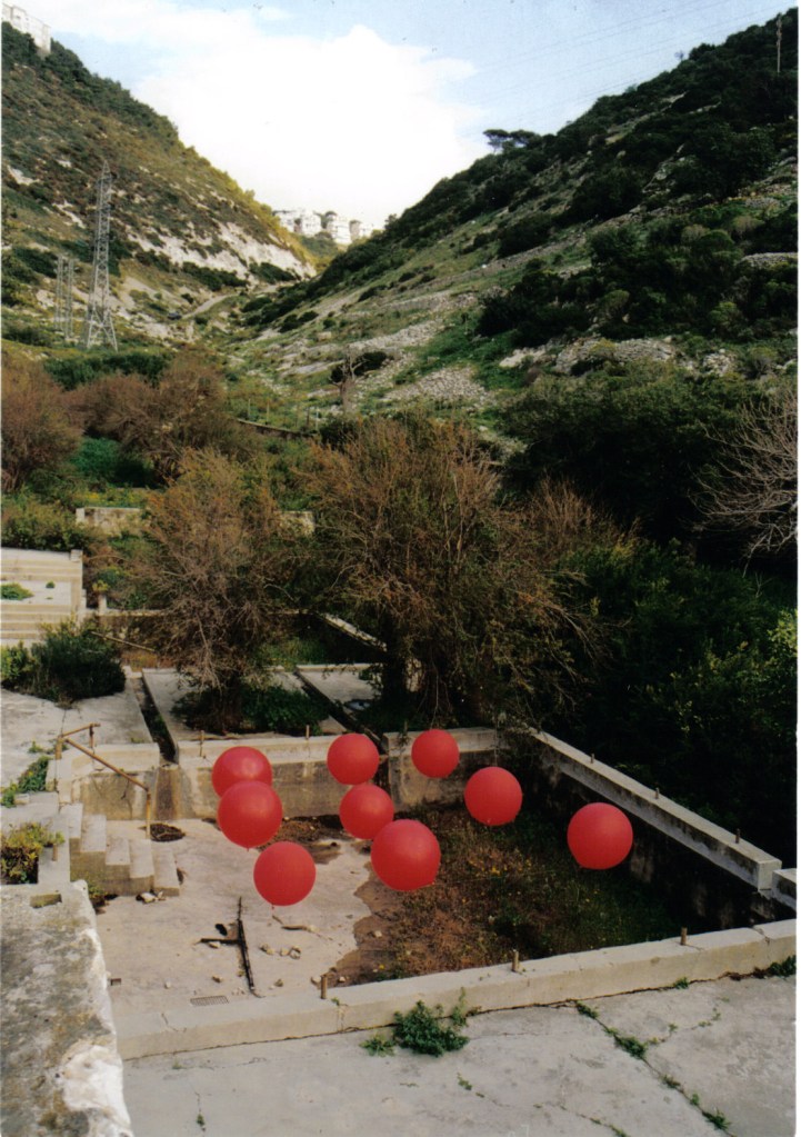
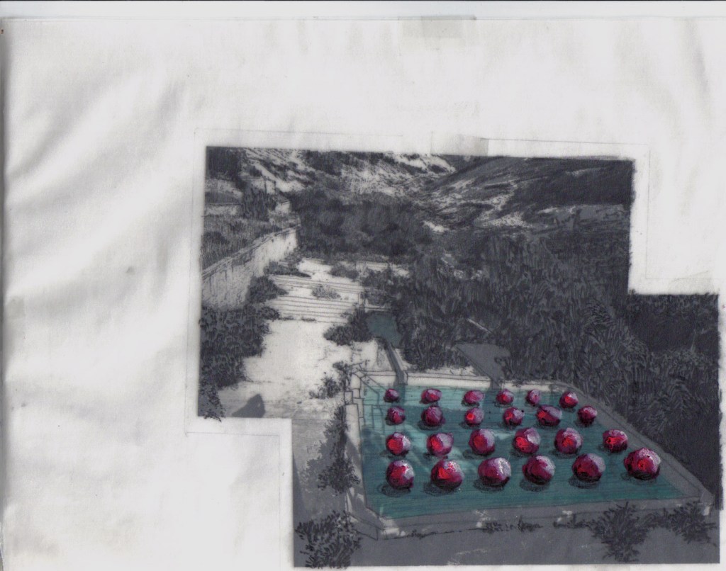
Between the years 2010-2013, I made three installations titled Gardens To Go, reacting to the displacement of landscape features, peoples, and trees, underlining the notion of deterritorialization and power in the landscape. The Gardens To Go attended to inherent dialectical tensions in gardens, sites, and human (im)mobility and drew on the concealed and unveiled power relations practiced in landscapes and urban spaces such as public gardens and groves. The installations – comprised of a whole freshwater ecosystem of ponds or water tanks – suggested variations of an uprooted garden while implying the vibrating desire of the ponds as the garden's core conveying both its Eros and Thanatos. The works suggested a deconstructed and fragmented in-situ garden's core which unfolded against their surroundings, unveiling the elusive nature of landscape and gardens.
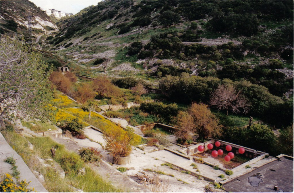
The installation Water Lilies Garden To Go #1 was realized in September 2010 as a part of the Shapira neighborhood art festival near the Tel Aviv central bus station. It lasted for only three days, in a neighborhood where temporary olive groves instantly appeared and where many of its residents are work immigrants and foreigners. The semi-opaque plastic water tanks contained Water Lilies (Nymphaeaceae), Mosquitofish (Gambusia affinis), and tiny frogs. Its lively unmediated character appealed to the neighborhood's children that enjoyed a hands-on experience of the work. It was positioned at an empty plot, similar to those with the temporary groves, thus echoing the same practice. The work reflected on political-ideological conflicts in Israeli society concerning the status of refugees, asylum seekers, and work immigrants. It resonated with similar dialectics as the instant olive groves, implying the convergence of power and mobility of people and plants.
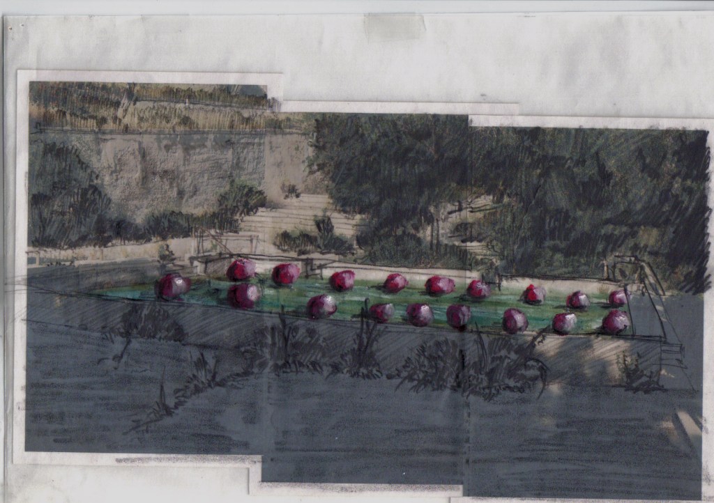
In the summer of 2011, the installation Water Lilies Gardens To Go #2 was displayed at the Inga Gallery in Tel Aviv, adjacent to its previous location in Shapira neighborhood. The gallery is located within a rough setting of industrial buildings of medium-small factories, workshops, and warehouses. It gradually became repopulated with artists' studios and galleries in the process of gentrification that pushed out the original residents but also the foreign new ones. At the gallery's inner court, the work further unfolded, performing an act of reterritorialization of its fragments. The deconstructed garden's core formed a hybrid garden that conveyed the conflicts of its surroundings with reflection on Monet's Water Lilies paintings. It also resonated with the dialectics of deterritorialization and trauma, temporality and instantaneous, and the ambiguous performance of power relations in landscapes and gardens (Meishar, 2017).
The installation Water Lilies Garden o Go #1 in Shapira neighborhood, Tel Aviv, Photo: Efrat Hildesheim, 2011.
The installation Water Lilies Garden To Go #2 in Inga Gallery, Tel Aviv, Photo: Efrat Hildesheim, 2011.
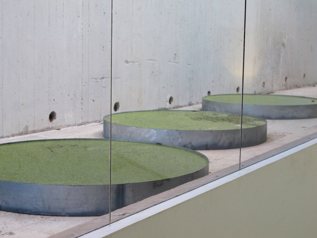
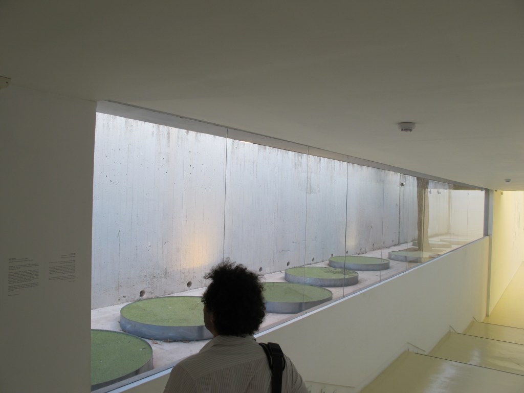
Lemnaceae is a garden installation that was displayed in the Herzliya Museum of Contemporary Art at the exhibition Other People’s Problems: Conflicts and Paradoxes, curated by Doreet Levitte Harten and Dalia Levin in the fall of 2013. The work was composed of eight metal water ponds (110-120 cm. Diameter / 15 cm. height), Duckweed/water lenses (Lemnaceae), Mosquitofish (Gambusia affinis), and pieces of waste and garbage (cigarette butts, cans, snacks' wrappers, bottle caps). It was situated in a sunken, narrow courtyard that the public could not reach, between the museum and the street above. The spectators, viewing the work from behind great glass windows along a steep staircases hallway, could not fully perceive the work as a whole because of the changing viewpoint along the staircase.
The name of the work – Lemnaceae – refers to the aquatic plants, a species that is either rootless or has simple rootlets and thus floats on the surface of freshwater bodies. The floating Lemnaceae is the antipode of the olive grove. Its performance alluded to the paradox of (im)mobile garden. This third version of Gardens To Go pertains to power and deterritorialization not only through the dialectics of the temporal and (im)mobile, but also through the notions of desire, the anamorphic view, and the mode of the diorama. These leads of discussion suggest that power may be indirect, ambiguous, and elusive yet inherent to the idea of the garden. Taken together, they unfolded the idea of a nomadic garden – a garden without a territory – thus defying the idea of territoriality and power.
In Lemnaceae, positioning the ponds in the empty concrete courtyard next to an existing Elm tree (Ulmus) enhanced the tensions of the temporal and the (im)mobile discussed earlier in the article. It is even more noticeable considering the spatial proportions: the courtyard level is higher than the level inside the museum. As a result, the ponds are situated within the viewer's eye level, appearing as if floating and unconnected to the ground.
This location within the open court between the museum and the street means that it is concurrently part of the museum and outside its main building, allowing a close yet detached parted view of the ponds. It evokes the discussion on desire, the anamorphic view, and the dioramic mode that relate to the spectator's experience, its changing point of view, and its relation to movement and desire that motivate that view.
When viewing the work while in movement, it either gradually disappeared when one was on his way downstairs or reappeared and was revealed on the way upstairs, amplifying the sense of floating, uncertainty, and disequilibrium. The natural movement and vision that generally occurs within a 'normal' garden were converted in this case by a vector of descending/ascending the stairs, producing a reversal of momentum and therefore an inevitable disappearance/reappearance of the garden's sight. This momentum operated as an anamorphic mechanism of space in which perception depends on movement, and therefore the sight of the garden was perceived from an enhanced perspective. The anamorphic vector of sight constituted through movement is motivated by the desire to capture the whole work in one sight (Žižek 1991; Weiss 1995: 39; Hildesheim 2020). In Lemnaceae, the level differences, the vector of movement, and the wide thick glass restricted the spectators from capturing the work as a whole, making them walk up and down the stairs and along the window, thus manipulating their move and gaze. The anamorphic mechanism prevented the spectators from achieving it hence the partially satisfied desire to see Observing the garden through the large window glass brings to mind the experience of looking at a scene displayed in a habitat dioramas exhibition, typical to museums of natural history. The viewers acquiesce to the illusion that the dioramas provide through the three-dimensional scene built within the narrow space of the displayed scene. The dioramas offer a reterritorialization of nature and landscape. Repositioned behind a window and heavily illuminated, nature and landscapes are then objectified and dramatized in the service of science. The habitat dioramas regulate the power relations between the viewers and the scene. In museums of natural history, they not only order the spectators' view but also relate to power relations in the landscape by manifesting anthropocentric perception of nature and often also reveal a colonialist approach towards the displayed theme.
The work Lemnaceae undertakes a similar convergence of art, gardens, and science. The dioramic modus in Lemnaceae evokes these power relations and a theatrical view of the garden's performance, a distanced perception of 'nature'/landscape. While performing a reterritorialization of (eight) ecosystems, it recalls the garden's origin as a cabinet of curiosities and its resonance in natural history museums, archeological museums, and botanical gardens (Graham 1993: 286-307; Garcia and Normand 2019: 141-150). The Dioramic gaze provokes the spectators' idea of the garden and its perception of the concealed subtle conflicts and dialectics it conveys.
The installation Lemnaceae in the Herzliya Museum of Contemporary Art. Photo: Efrat Hildesheim, 2013.
References: Aronson, Shlomo. (1998). Making Peace with the Land. Washington, DC: Spacemaker Press. Deleuze, G., and Guattari, F. (1987). A Thousand Plateaus: Capitalism and Schizophrenia. Minneapolis: University of Minnesota Press. Garcia, T. and Normand, V. (2019). On the aestheticization, institunalization, and dramatization of the concept of nature. In Tristan Garcia and Vincent Normand (eds) Theater, Gardens, Bestiary: A Materialist History of Exhibitions. ECAL/University of Art and Design Lausanne and Sternberg Press. Graham, D. (1993). Garden as Theatre as Museum. In Dan Graham and Brian Wallis Rock My Religion: Writings and Projects 1965-1990 (Writing Art). Massachusetts: MIT Press. Hildesheim, E. (2020) Landscape syncope: desire, power and the presence-absence of landscape, Culture, Theory and Critique, 61:4, 404-423, DOI: 10.1080/14735784.2021.1912621 Meishar, N. (2017). Up/rooting: Breaching landscape architecture in the Jewish-Arab city. AJS Review 41:1, 89-109. doi:10.1017/S0364009417000101 Mitchell, W. J. T. (2002). Landscape and Power. Chicago: The University of Chicago Press. Weiss, A. S. (1995). Mirrors of Infinity: The French Formal Garden and 17th-Century Metaphysics. New York: Princeton Architectural Press. Žižek, S. (1991). Looking Awry: An Introduction to Jacques Lacan Through Popular Culture. Cambridge, MA and London: An October Book, The MIT Press.
Abstract: This paper is an interdisciplinary critical inquiry that conceptualizes the mechanism of signboards as a means of order and control in the borderoadscape of Israel’s Highway 90 and the country’s eastern border with Jordan. Drawing on W.J.T. Mitchell’s critical perception of landscape and power, Althusser’s concept of ideological state apparatuses, and Billing’s “banal nationalism,” the discussion examines the landscape performance of signboards in the borderoadscape as both instrumental and symbolic: whereas its instrumental dimension involves the administrative management, regimentation, and control of this designated space, its symbolic dimension is obscured and charged with political and sociocultural aspects. The paper draws on the coined notion of borderoad to convey the juxtaposition and the affinities between the border and the highway – both extending along the Great Rift Valley – as well as their geo-political context, while underscoring the liminality of the space and the landscape they constitute. Accordingly, the hybrid borderoadscape offers a way of perceiving the border, the road, and the landscape as a whole, pointing to the intersection of power and landscape as a cultural practice. Due to the area’s topography, the border is largely concealed as one drives along it, defying its prominent presence in Israelis' collective consciousness. Hence, the paper reveals the landscape performance of the signboards along the route as an interpellative mechanism operating to implement control and order, through the subjection of the individual to the state ideology, while enhancing national identity and collective consciousness. Three themes of the signboard system are explored: the banal, the local, and the national; sovereignty, territoriality, and control; and the military-civilian dialectics. The discussion points to signboard practices as an agent of ideology operating in the landscape. The intertwinement of infrastructure, control, order, and ideological formation reveals the political-ideological facet of the borderoadscape.
Introduction
Signboards position texts in the landscape. In the early Renaissance period, with the appearance of the arboretum (Hortus Botanicus), plaques and small signboards became part of the of the botanical garden's landscape, serving to denote different types of plants. The methods of classification developed in these gardens heralded the development of taxonomy and the scientific methods of categorizing species. They also heralded a strategy of controlling and regimenting nature and natural growth, which reached its apogee in formal Baroque gardens and in picturesque English landscape gardens. The French philosopher Michel Foucault (1966) refers to this system of regimenting nature as “the Cartesian mechanism.”[1] The small scientific plaques in the vicinity of every species of plant, flower, tree or bush operated as a landscape performance characteristic of the botanical garden, while manifesting it as a natural sphere that is administered, regimented, and subjected to rigid scientific rules. This process of ordering and controlling was applied not only to nature, but also to those visiting it. The performance of texts and signs in the landscape/garden reveals the illusion of the picturesque, the pastoral, and the so-called natural, while disclosing the viewer’s position in relation to the landscape. This practice reveals the manner in which spaces and landscape performances – "whether they are put there by the physical transformation of a place in landscape gardening and architecture, or found in a place formed, as we say 'by nature'" (Mitchell 2002a, 14)"[2] – are administered ordered, and regimented, subjecting the visitor to various constructions. Signboards offering directions, orders, warnings, or information concerning monuments, observatories, panoramic viewpoints, exits, rest areas, etc. come together to constitute a landscape performance of order and control – be it a garden, a park, a hiking trail, or a highway. This practice partakes of a mechanism of regimentation and administration that makes manifest as an ideological mechanism.
This paper draws on W.J.T. Mitchell’s conceptual and critical approach in Landscape and Power (2002b), which relates to landscape as a medium and cultural agent: “Landscape, we suggest, doesn't merely signify or symbolize power relations; it is an instrument of cultural power, perhaps even an agent of power” (Mitchell 2002b, 1-2). From this perspective, landscape is a matrix of mechanisms, practices and performances that both form and are formed as agents of power and ideology. The notion of landscape performance thus points to certain characteristics of the landscape that operate beyond representation, and include landscape’s performative qualities and the visual-spatial practices unfolding within it. This perspective focuses on the landscape’s mode of operation, not only as a semiotic system but also as a phenomenological-performative arrangement: “landscape as a medium, a vast network of cultural codes” (Mitchell 2002a, 13).
In the essay Ideology and Ideological States Apparatuses (Althusser 1971), the French philosopher Louis Althusser coined the notion of interpellation as a mechanism that subjects individuals to the state's ideological apparatuses by maintaining the formation of (collective) identity. The course of interpellation is a summons for the individual to identify with the state's ideology and it operates by means of performative practices. According to Althusser, a practice of any kind unfolds under the aegis of ideology. Ideology, he argues, has a material existence, operating by means of a subject and for subjects. In this light, landscape apparatuses and their associated functional matrixes operate as agents that constitute subjection and identity, functioning as mechanisms of discipline and control without revealing themselves as such, so that their performance appears transparent and obvious. Hence, I refer to practices that operate in the landscape as “landscape interpellation”. This argument builds on Mitchell’s approach to landscape formation as an utterance of dominant ideologies, which form landscape performances.
The third critical idea addressed in the article is the notion of “banal nationalism,” coined by the sociologist Michael Billing (1995). Billing has shown that despite its radical image, nationalism is not necessarily an expression of socio-ideological extremism, but is rather everywhere as part of everyday life in a sovereign state (from bills, coins and postage stamps to narratives and myths). The ideological halo of nationalism, according to Billing, operates in the context of power, yet performances of this power range between two poles: banal, everyday performances and extreme, radical performances, which Billing terms “hot nationalism.” Billing argues that once a state’s sovereignty becomes established, its national symbols are assimilated into the banal and absorbed into culture and language (Billing 1995, 41). Thus, while 'hot' nationalism usually stands out and calls attention to itself, banal nationalism tends to be assimilated into everyday life – landscape, in this case. These three critical approaches will complement each other in the conceptualization of the signboards of the borderoad landscape.
The following discussion will examine the landscape performance of signboards as an infrastructure in the borderoad of Highway 90, arguing for their double functional which is both instrumental and symbolic: whereas its instrumental dimension involves the administrative management and control, its symbolic dimension is obscured and charged with political and sociocultural aspects, serving as an agent of ideology. The article addresses the following question: How do signboards operate in the landscape to form order and control through the interpellative mechanism – a mechanism that implements control and order, with and through ideological formation, while promoting national identity and collective consciousness (Althusser 1971). Addressing this question, I will argue that the signboards' seemingly objective and natural appearance, and their obvious administrative function, conceal their political facet as an interpellative mechanism. By revealing them to be a landscape infrastructure, I will show the power of landscape as a political agent of ideology, and suggest that what is being subjected, ordered and controlled is not only the territory or the movement of people, but also their consciousness and identity.
The perception of landscape as well as its interpretation and conceptualization are the outcome of the viewer's positionality, and affected by many factors – in this case nationality, citizenship, and geopolitical affiliation are the first of many other relevant positions. In this case, the author’s positionality is that of an Israeli-Jewish woman driver, a frequent traveler along Highway 90. This fact should be noted, since the discussion on interpellation binds together (collective) identity, consciousness and ideology, and is thus political and conflictual. However, in pointing to different aspects of the relations between sovereign and subject in the landscape, the current argument does not assume a single, general subject, but rather acknowledges that various types of subjects are active in the sphere under discussion – including Israelis, Palestinians, tourists, local residents, regular visitors, and others. The act of interpellation operates differently in relation to different subjects. As I argue, the agents of ideology seek to inerpellate the individual, undertaking actions even if the individual resists them. In this manner, indifference or even rage against this course still subjects the individual to the ideology of the sovereign (even momentarily), creating a confrontation between them.
I argue that since landscape interpellations are everywhere, one cannot entirely reject being subjected. One is not obliged to identify or accept the suggested ideology, yet one cannot ignore it, and therefore must confront it. In this manner, the signboards of the borderoad (most of them are in Hebrew, English, and Arabic) operate as a political means of acknowledging and manifesting of the presence, sovereignty, and ideology of the state.
The paper addresses three themes, each pertaining to a different conceptual facet of the signboard system: The banal, the local, and the national – which mainly concerns the naming of streams on the borderoad landscape; facets of territorialization, sovereignty and border; and the military-civilian dialectic as expressed in IDF and military-related signs. Each theme presents a critical-geographical theory relevant to the discussion, and demonstrates how the three themes interrelate and complement one another. The discussion probes the political-ideological facets of the borderoadscape, which assimilate the banal, the normal and the extreme. Taken together, these themes indicate that power lies in the trivial, banal, everyday characteristics of the landscape. The obviousness of the road signboards in the landscape, much like the obvious presence of the landscape itself, enables interpellative mechanisms to take their course. Hence they operate to implement control and order through interpellation, while enhancing national identity and collective consciousness.
The borderoad: geographical and conceptual framework concerning the border, the highway, and the landscape
Israel’s eastern border with Jordan extends along the Great Rift Valley from Eilat in the south, through the Arava Desert, along the Dead Sea, and through the Jordan Valley/west Bank, all the way to the border with Syria south of the Sea of Galilee, at the meeting point between Israel, Jordan and Syria. The segment of the border running along the West Bank – from the northwestern part of the Dead Sea to the checkpoint in the northern part of the Jordan Valley, on the Green Line (the 1949 armistice agreement line) – was defined in the Israeli-Jordanian peace treaty as an administrative border.[3] This border encapsulates many of the region's conflicts: the ongoing military tensions between Israel and Syria; the quite yet cold peace with Jordan; and the continual dispute over the occupied territories in the West Bank.
Highway 90, the longest route in Israel (478 kilometers), extends from Israel’s southern border with Egypt to its northern border with Lebanon, and runs adjacent and parallel to Israel’s eastern border. About one-quarter of the route (118 kilometers) passes through the disputed territory of the West Bank. Its northern segment (from the Hula Valley to Metula) runs close to the ceasefire line between Israel and Syria, drawn after the 1948 war.[4]
Historically, Highway 90 is a relatively new route, although many of its segments have their roots in ancient times.[5] Until 1971, it existed only partially and its segments – some of which were not even built – were controlled by various sovereignties: The British mandate in Palestine until 1948; after the establishment of the State of Israel, the route's northern and southern segments were positioned on the Israeli side, and its West Bank segment became part of the Hashemite Kingdom of Jordan; after the 1967 war, the West Bank was occupied by Israel, and since then this segment is managed by the IDF Civil Administration and is under informal Israeli sovereignty.[6]The 35 Km. long segment of Ein Gedi–Ein Feshkha in the Judea Desert, built in 1971, connected the north and the south of the state, while making the road whole and complete (Hildesheim 2022). Even today, Highway 90 is fabricated from various segments, known as the Arava Road, the Dead Sea Road, and the Jordan Valley Road along the West Bank. While some are national highways of the highest quality, others are outdated, two-lane, single-carriageways in poor condition. Even so, despite its segmentation and the differences in width, maintenance, and classification, it operates as a complete route that serves its users as well as the state as a functional, symbolic and ideological medium. The entire highway constitutes a liminal political, cultural and social landscape, pervaded by national ethoses and myths, layers of history, and intense political-ideological intricacy. These tensions and conflicts are consequently expressed and reflected in the signboards along the route.
Due to topographic conditions that obscure the distinct location of the border, and the absence of prominent fences or walls, the state's eastern border remains largely blurred as one drives along it. Hence, the border – a site of continuous conflict and control – appears intangible and, in effect, absent from the visible space. Its elusive performance stands in contrast to its presence in Israeli collective consciousness, forming it as a present-absent border. As a result, Highway 90 operates in practice as a semi-civil, semi-military space, and its landscape maintains the dialectics of civilian vs. military space, free movement vs. control and surveillance, and presence vs. absence.
The discussion of Israel’s eastern border and Highway 90 makes use of the notion borderoadto describe the hybrid space of the road and the border. Given the proximity of the road and the border, the notion of the borderoadwas coined to convey the juxtaposition and the affinities between the border and the highway aligned with it, as well as their geo-political context, while underscoring the liminality of the space and the landscape they constitute. The notion borderoadscape, meanwhile, focuses the discussion on landscape as one aspect of this space. The hybrid borderoadscape offers a way of perceiving the border, the road, and the landscape as a whole, and of exploring the intersection of power and landscape as cultural practice (Mitchell 2002b). The borderoad and the related notions – borderoadscape and borderoadspace – do not only describe but also suggest modes of perception, observation and operation in a space.[7] The borderoadscape (Hildesheim 2020, 2022) is thus the site of mechanisms, practices, and everyday landscape performances that aim to establish order and control as well as construct a collective national identity. In this context, the system of signboards along the highway is a part of that landscape.
The banal, the local, and the national: naming and the signboards of river and streams
Roadsigns and signboards, including traffic signboards and directive signs concerning destinations and distances, are designed to be read while driving at high speed, constituting a conspicuous and multifaceted landscape performance along highways. In the borderoadscape, they have an undeniable presence in the landscape.
Tim Edensor (2003, 2004), Rhys Jones and Peter Merriman (Jones and Merriman 2009; Merriman and Jones 2009) discuss the political character of banal, everyday signage systems on roads, while building on the notion of banal nationalism coined Billing (1995). Similar ideas are explored in the critical-geographical discussion of toponomy that sees naming as a symbolic practice designed to construct a national-spatial identity and consciousness (Rose-Redwood et al. 2010; Berg and Vuolteenaho 2009; Azaryahu and Kook 2012; Nash 1999; Cohen and Kliot 1992l). In the case of Israel, historian Meron Benvenisti (1997) argues that Hebraizing the landscape and the use of new-old names played a role in underscoring the Jewish people’s right to return to its homeland and in establishing a connection with its landscapes, serving as “a powerful means of transforming the spiritual homeland into a concrete, real homeland” (ibid, 25). In this context, the Hebraizing of place names and geographical objects operates as a national strategy, intended to establish physical and symbolic sovereignty and a formation of a linguistic landscape that makes use of the visibility of language to establish a hegemonic narrative.[8] These works have focused on naming and collective memory in everyday spaces, pointing to the geopolitics of memory and revealing the political meaning of naming, and its role in the formation of national ideological infrastructures in the landscape. Their everyday character, show the affinity these practices share with Billing's idea of banal nationalism. Yet whereas Billing underscores the dichotomy between the 'hot'/radical and the banal, Jones and Merriman (2009) point to the manner in which they are assimilated into one another. When these boundaries are blurred, the everyday is located in between them (ibid, 166).
In their discussion concerning the struggle over bilingual road signage in Wales, Jones and Merriman examine expressions of Welsh nationalism and the ideological position of the sovereign as performed by traffic signboards. Influenced by the discussion of the everyday and its production of space (LeFebvre 1991 [1947]), and of the everyday in the road space (Edensor 2003, 2004; Merriman 2007), they indicate traffic signboards as a sovereign practice for subjecting the drivers to the state and realizing its sovereignty. This means, using Althuserrian terms, that they point to the manner in which traffic signboards operate as ideological agents. They show how the banal-technical and the political 'hot'/extreme are assimilated into one another, so that the technical-ordinary becomes political. In this manner, they point to the ambiguous expanse between radical, conspicuous nationalism and banal, transparent nationalism that is invisible to the eye yet exists on an everyday level. Merriman and Jones underscore the political meaning in the way sovereign bodies position road signs as banal, functional objects that are part of the roadscape, while operating as a political-ideological mechanism.[9]
Tim Edensor (2003, 2004) also follows Billing’s notion, and examines the ways in which motorscapes form national identity by means of symbols, practices and phenomenological performances. Edensor distinguishes between symbolic sites (landmarks such as castles, towers or ruins) and everyday national signifiers: “national motorscapes are primarily constituted out of those everyday, institutional spatial signifiers distributed across road networks" (Edensor 2004, 108).[10] Roadsigns, according to Edensor, are part of an institutional matrix of everyday life which, together with other vernacular, quotidian motorscapes, constitute a collective consciousness through "nationalspatialization" (ibid, ibid).[11] Whereas Merriman and Jones see the everyday as the assimilation of the banal into the hot and radical, Edensor indicates the everyday character of the road space as the assimilation of the local into the national: “The comfort of spatial identity is fostered by the thick intertextuality of those vernacular, generic motorscapes for they stich the local and the national together through their serial reproduction across space” (Edensor 2004, 108).
The shaping of national identity by means of borders and related elements is part of a strategy of social construction that establishes a nation within a defined territory. It is clearly present in relation to military concerns, and its performances in the borderadscape of Highway 90 are varied – including remains of bunkers, military posts, former Jordanian and British military facilities, occasional stretches of fences and barbed wire, patrol roads and communication trenches. Together, these elements become part of landscape performance of the borderoad. Hence, the borderoadspace of the everyday is a fusion of the banal civilian life unfolding along that route, and of the 'hot,' urgent and state-of-emergency stemming from the apparent military concerns pertaining to the border. This fusion reflects the military-civilian dialectics of the borderoad (which will be discussed extensively later in this paper): in a space where the prevalent ideology is based on control and military concerns, the everyday is also fused with the urgent and extreme, and vice versa. This is further enhanced by the historical-archaeological and mythological dimension, also reflected by the signage system along the borderoad, which includes biblical references and national myths, also described by Edensor (2003, 2004), Azaryahu and Kook (2012) and others.
Located all along Highway 90 are (brown) signboards providing information on national sites including archaeological sites, national parks and nature reserves, tourist attractions, and private tourism initiatives. Additional signboards bear the names of the streams and ravines traversed by the route.[12] The signboards regarding these sites, especially those with a national context, are part of what Edensor, as well as Merriman and Jones, refer to as a means to constitute a collective consciousness through national spatialization, revealing them to be a political practice. However, despite the resemblance between these two types of signboards, there exists a significant difference between those pointing to (national) tourist destinations and those pointing to streams. Whereas in the first case the destination can only be reached by means of the highway, in the second case the signboard merely conveys information – the name of a stream – even though it is usually not possible to turn off the highway and walk along the steam at that very spot.[13] The discussion of this second type of signs underscores their manner of operating in space and in the landscape.
Signboard providing information about the Zin River passing beneath Highway 90, Arava Desert. (Efrat Hildesheim, 2017)
The names of the streams and ravines situated within the landscape convey national significance, contributing to the formation of collective consciousness and identity (Benvenisti 1997), and are therefore an interpellative mechanism. Along Highway 90 they are perceived by those driving along the route as part of the landscape. The car’s velocity accelerates the process of internalizing and impressing the names upon consciousness; the fact that the signs merely provide information does not diminish the power of this strategy, but rather reinforces it by means of intensity and repetition. This practice serves to deepen one’s acquaintance with a given place. In the case of tourists or non-Israeli travelers, it will promote a recognition of the unification of place-state and of the state sovereignty and power, whereas for Israelis it operates to enhance national identity as part of the constitution of nationhood (Edensor 2004, 111). Much like the practices of hiking, walking along streambeds and 'conquering' the land with one’s feet, the action of driving along the road and memorizing the names of the streams symbolically represents a conquest of the land on every road trip. An acquaintance with the names of the streams in their immediate spatial context, while driving at high speed, is part of a complex matrix of practices which establishes a consciousness of place through familiarity with the land. This casual educational practice is aimed at deepening the connection between the travelers and the place, stream, road and country as a whole. The practice of signboards designating streams is at once part of the local landscape and a form of consolidating identification with a national narrative and with the collective ethos of the state and nation, in a manner similarly described by Edensor (2004). In Edensor’s terms, the signboards indicating the streams appear as banal, normal and local; yet as part of an overall signboards system, they also partake of the national and the collective register, so that the everyday practice ties between local and national identity, employing an interpellative course that strives to unify identity as part of establishing sovereignty and nationhood.[14] It should be noted though, that for non-Israeli travelers, tourists, minorities, or Palestinians residents of the region, this course of interpellation does not operate in the same manner, since the course of identification with the state is either irrelevant or antagonizing. Nevertheless, the banal appearance of the signboards conveys a geo-political ideological statement, and therefore confronts the travelers by enhancing acknowledgment of the state's ideology.
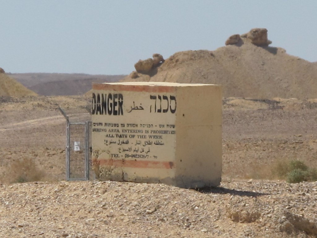
Signboards near the Dead Sea warning against entering an area with suspected minefields (upper image), and warning against sinkholes and forbidding access to the beach after dark (lower image) (Efrat Hildesheim, 2021)
This aspect of the road also relates to a-symmetry as another characteristic of the borderoadspace, with the border on its eastern side operating as a sort of 'invisible wall'. The appearance of the streams’ names together with military signboards underscores this asymmetry, therefore accentuating the elusive presence of the border. As noted, the proximity to the border prevents travelers from stopping their car or accessing the stream in the vicinity of the signboards. East of the highway are the border, the patrol road, occasional stretches of barbed wire, and even remains of minefields. For this reason, in most segments of the route it is prohibited to turn off the road to the east, and possible turnoffs are generally blocked. This practice emphasizes the subtle present-absent existence of the border itself, supporting the fixation of its presence in local and national Israelis' collective consciousness.
The signboards indicating the streams offer an example of their complex functionality in both, forming a collective national identity for Israelis, and accentuating the state's control over the landscape for other (non-Israeli) travelers. At the same time, there exists an everyday vacillation between the trivial and banal on the one hand, and between urgent and 'hot' states on the other, as the line between these states is blurred in numerous ways. Returning to the point made by Endsor, as well as by Merriman and Jones, one can note that the seemingly trivial presence of signboards in the borderoadspace exists as a multitude of traffic signposts, instructions and warning signs situated thereby various agents. Some are placed by the central signage authority (which is responsible for road traffic and security); some are placed by local municipalities/authorities; while others by the IDF, which employs an explicit border-related visual language that charges the landscape with further 'hot' military/war-zone meanings (to be discussed in detail in relation to the third theme). See for instance, the yellow warning signs found in areas suspected of containing minefields, alongside with warning signs concerning the Dead Sea sinkholes, and sign that warn against over-night stay by the Dead Sea beach . Taken together, they make a banal, yet 'hot' landscape performance of the borderoad that orders the space, while subjecting the drivers to the state's power and contributing to the formation of Israeli collective identity as "a code of a larger significance" (Sopher 1979, 158 cited in Edensor 2004, 111), with the border playing a significant role in this process.
Facets of territorialization, sovereignty and border
The system of traffic signboards and roadsigns (colored green and blue in Israel) that denotes destinations and distances similarly operates as practices of controlling the space through naming, denoting, informing and measuring. On the same note, I argue that these practices serve not only to define the territory of the nation-state, but also to demonstrate its presence in the disputed territories – the occupied territories of the West Bank – where the state seeks to manifest and accentuates its (semi-official) sovereignty. The following discussion reveals how signboards articulate the relations between subject and sovereign in the borderoad landscape and operate to ensure control and order.
Changes in perceptions of territory, of modern sovereignty, and of the border as social constructions (Paasi 2003, 2010; van Houtum 2005, 2011) have until recently pointed to the shift from practices that are directly related to territory – walls, border markings, military control of territory, etc. – to practices related to the management and control of movement in order to impose sovereignty (Foucault 2007; Ammore 2006). Stuart Elden (2007, 2010) offers an approach that ties together territory and the manifestation of sovereignty by means of mechanisms and practices for administering and controlling both territory and population in space. Nevertheless, the global refugee crisis and the waves of immigration to the West over the past decade have led to the formulation of new approaches concerned with the return of territorial borders and the establishment of landscapes containing actual walls and physical borders as a concrete (yet symbolic) declaration of sovereign political power (Jones and Johnson 2014; Vallet and David 2012; Vallet 2014; Jones 2012). This discourse underscores the role of borders and walls as a territorial defense, not against another country but rather against non-state agents, in an attempt to manage and control the other/enemy (Minca and Rijke 2017; Brown 2010). Paul Virilio’s (2006 [1977]) pioneering discussion in Speed and Politics offers a far-reaching approach to the tension between sovereignty and territory. Virilio narrows the status of the territory by coining the term 'dromosphere' to describe the spatial-political sphere associated with velocity and movement. He argues that following “the dromocratic revolution,” practices of control and power are no longer dependent on the territory per se, but rather on fast movement. Fiona Wilson (2004, 529), by contrast, underscores the territory itself, coining the term “territorialization regime” in order to indicate how roads serve the sovereign as a means of occupying and controlling. Wilson argues that roads are therefore perceived as a project that is dictated from above, and are themselves a manifestation of the sovereign’s power.
Drawing on these arguments, I assert that signboard systems and the information they convey give expression to a sovereign power that controls, administers and regiments territory and movement. As such, signage is in fact a system for ordering society’s behavior in relation to a given territory while in fast movement (2006[1977]). One way in which signs mark territory and manifest sovereignty in the landscape is the apparently objective practice of denoting destinations (where to), directions (how to get there) and distances (how far). This information refers to places along a spatial continuum, and relates to the ongoing distance between the traveler’s location and the noted destination. Ariel Handel (2017) discusses distance as a political concept, and examines processes of distanciation, pointing to them as political strategies and as a practice of territorialization, or a “distanciation regime.” Handel shows how territorialization enacts a composite action: it produces a continuum of places in space by defining them, the distance between them, and a relationship of proximity between the different places (Handel 2017). He points to a monopoly on territorialization (Handel 2007, 120), according to which the sovereign controlling the space is the one who has exclusive control over definitions of “close” and “far.”
The borderoad operates as a dromoscopic space as the practice of marking places and informing about distances on road signs is reserved to the sovereign, and serves to imprint them as a territorial continuum in the travelers' consciousness. When the roadsigns in the borderoadspace inform the traveler about the distance to a place further along the road and to the final destination – in the case of Israeli Highway 90, Eilat in the south or Metula/Kiryat Shemona in the north – they define the whole territory of the state, bringing these destinations “closer” together and creating a consciousness of a territorial continuum. The sovereign’s monopoly on territorialization, using Handel's terms, also serves to select the destinations to which travelers are directed, and thus also functions as a political practice: in Althusser’s terms, the signboards operate as a summons for the traveler to identify with the state by means of signifying and ordering territory, place, and landscape and identify with this territory. This practice, specifically in the borderoad landscape, is a means of constructing consciousness through minor yet insistent means: "nationhood is near the surface of contemporary life . . . . Small words rather than grand memorable phrases, offer constant, but barely conscious reminder of the homeland, making 'our' national identity unforgettable" (Billing 1995, 93). Nevertheless, even for non-Israelis, signboards in the borderoadscape are a materialization of the sovereign ideology, operating as a practice whose obviousness serves to conceal itself.
An information signboard with the inscription “Masada 17 Eilat 230,” Highway 90 south of Ein Gedi. (Efrat Hildesheim, 2021).
Edensor uses the term “national spatialization” to draw a connection between national identity and spatial perception (Edensor 2004, 108). As in the case of the names of streams – and especially concerning names of destinations charged with national significance that function as a “national code” – the repetition of the final destination and the diminishing distance to it, act as part of the interpellative course. The visual salience of place names in the landscape and in the context of national ethoses and Jewish traditional myths works as a practice for the mythification of landscape, enhancing national narratives. See for instance the signboard informing about “Masada” and “Eilat”, designating them both as national destinations. “Masada” is an archaeological site that has gained the status of a national-Jewish myth as the last stronghold of the Jewish revolt against the Romans in 73 CE.[15] The tourist city of Eilat, meanwhile, is a symbol of escapist freedom and of the ultimate vacation site. As the final destination on Highway 90, it represents the far end of the Israeli territory. In this manner, the functional landscape practice of informing about place name acts to form a continuum of “national spatialization.” It underscores the state's power to define its territory, and to include within it the disputed territories, while also imposing this position on the traveler.
A signboard pointing to the memorial for the Israelis who attempted to reach Petra in the 1950s.Highway 90 Arava Desert. (Efrat Hildesheim, 2017).
This practice also operates to mythify the borderspace itself, as revealed by the signboard noting the memorial for “Those who set off for Petra”.[16] The memorial is positioned east of the highway, adjacent to the patrol road and the border, and is not visible from the highway while travelling. The memorial overlooks the border in the direction of Petra (Jordan), the fabled Nabatean city that became an unattainable source of attraction for Israelis in the 1950s. The narrative concerning “those who set off for Petra” was formed around the heroic yet questionable departures of young Israeli adventurers, who lost their lives in attempts to cross the border to the Jordanian side, which was then an enemy state, and to visit the forbidden site. This narrative has been commemorated in popular Israeli culture, as well as in this memorial. The fact that the sign uses only Hebrew reveals the addressees to whom it is directed –- mainly Jewish-Israelis in this case – as an internal cultural code implying the nexus of contemporary Israel with ancient and biblical history, as well as with its border-related disputes and the pre-state era. However, there is no need to turn off the road and reach the memorial in order to activate the interpellative mechanism. Suffice is to notice, while driving at high speed, the signboard pointing to the site, which marks not only the memorial’s location, but also the presence-absence of the invisible border and the mythological feat of traversing it clandestinely and walking to “The Red Rock.”[17]
The present absence border is further manifested in the signboards system. It is obviously made present in the signs pointing to border checkpoints, yet it is also subtly present in other types of signboards referring to additional and related practices: lookouts and rest areas near the border, local and national memorials, and often memorials that are also border-observation points. Taken together, they assimilate practices related to the ethos of the border, and to the desire to see and symbolically transgress it (Hildesheim 2020). The presence of the border is also subtly expressed due to the spatial asymmetry stemming from the geopolitical conditions mentioned earlier. Thus, the system of civilian signboards underscores the north-south axis along the borderoad, and is mainly directed at destinations to the west of the borderoad: kibbutzim, villages, settlements, and small towns. In this manner, the signboards system not only defines the territory and the state’s sovereignty over it, but also circumscribes it, while often ignoring or minimalizing the presence of non-Israeli communities. The monopoly on territorialization (Handel 2007) is revealed once more through the reference to Israeli-Jewish places and the absence of sufficient references to Palestinian places – some of which are not officially recognized by the State of Israel.
Non-military signboards in the West Bank reveal an additional political-ideological aspect of landscape. Generally, the positioning of signage along highways requires the exclusive permission of Netivei Israel (the company that is in charge of planning and maintaining roads, formerly the Public Works Department). On the segment of Highway 90 running through the Jordan Valley in the West Bank, the Israeli/Palestinian dispute over the occupied territories is given an exclusive expression in the landscape: a prominently displayed signboards initiated by the Ministry of Tourism, which refer to this segment of Highway 90 as "Gandhi Road".[18] The road is named after former Minister of Tourism and former IDF Major General Rehavam Ze’evi – also called Gandhi. Ze’evi served as the head of Israel's central command of the IDF, and is identified with military operations in the Jordan Valley in the 1970s including border transgression, as well as with a radical right-wing ideological stance promoting the annexation of the West Bank to the State of Israel and the deportation of its Palestinian residents. The signboard “Gandhi Road” is not only an ideological declaration but it is the exception pointing to the rule: the laws of the State of Israel preclude the naming of highways or intersections after people; yet the naming of this segment after Ze’evi/Gandhi is possible, since Israeli law does not officially apply in the West Bank, and since Israel’s partial sovereignty in the Jordan Valley/ West Bank is overseen by the IDF Civil Administration. The “Gandhi” signboards thus serve not as an explicit form of control but rather as an implicit political-ideological declaration concerning this territory. They explicitly indicate the political performance of signboards – urging the traveler to acknowledge the legacy of the person after whom the road was named concerning the territories in dispute (even for non-Israelis) and also to identify with the ideology he represents. In Althusser’s notions, the signboards operate as ideological agents within the landscape – in itself an ideological agent – as those traveling along the road are subjected to them. Thus, while on the road, one cannot ignore this course: even if one does not agree to identify with or accept the ideology represented in the signboard, one is still confronting it, and is therefore subjected to it.
A signboard reading: "Gandi's Road," Highway 90, Jordan Valley / West Bank. (Efrat Hildesheim, 2011).
The military-civilian dialectics: IDF and military-related signs
The military-civilian dialectics is characteristic of Israeli society and space (Weizman 2007; Weizman and Segal 2003; Kimmerling 1983; Hochberg 2015). It is expressed in the landscape all around the country – army camps, signboards with unit codes or indicators of military assembly points, contemporary outdoor shelters, old British army pillboxes – yet the system of IDF military signage is an especially prominent characteristic of the borderoad landscape. Whereas the border and the road are distinguished in terms of their functionality, their symbolic dimension underscores their proximity and affinity with one another, while the landscape practices along the borderoad operate to preserve these dialectics. In this manner, the instrumental functionality of the military-related signboards as warning and deterrence practices is preserved, while their symbolic function operates as a practice for exercising power, regimenting and managing the space, landscape, and travelers. The military-related signboards complement the interpellative mechanism of the borderodscape by manifesting the present-absent border, subjecting the traveler to its power.
A study of archival materials reveals a history charged with discussions and correspondence on this subject such as those concerning roadside areas suspected of containing mines, between the IDF authorities, the PWD, and the local regional councils.[19] The continual discussion concerning the positioning of the minefield warning signs, and the responsibility for their maintenance, points to the importance the signboards carry in the landscape. Minefield warning signs are currently also scattered along the highway, especially on its eastern side, as discussed earlier. However, several other types of military signboards relate directly to the border: signs such as “Stop! border ahead”; “No passage, border ahead”; or “Border ahead, closed military zone” warn of proximity to the border, operating as an implicit threat. Other signs in the vicinity of the Dead Sea prohibit access to the coastline and remaining there after dark for military-security reasons. There are signboards warning Israelis against entering the Palestinian Authority, some of which assign criminal responsibility to those acting against the orders. Additional signboards are related to “firing zones” – areas designated for military purposes, which only military forces are allowed to enter. Markings designating these areas appear along extensive sections of the road (mainly in the south, West Bank, and Arava Desert) on both sides of the road, thus preventing from visiting, or even approaching the roadside in these areas.[20] Another type of signboards direct travelers to IDF bases, military posts, and so forth; most of these signs appear prosaically as standard official traffic or military signboards, yet others are partially improvised. Their multiplicity and the cumulative experience they form underscore the facet of the borderoad as a semi-military space.
Warning Block as a signboard: “Danger: Firing zone, Entrance is Forbidden also in Saturdays and Holidays” alongside Highway 90, south Arava Desert. (Efrat Hildesheim, 2017).
However, the discussion of military signboards – even more than the discussion concerning other signboards – raises the question concerning the subject-traveler who is being addressed, while reflecting the dialectics of the borderoad: Who do the signboards address? Who are they intended to control, order, and regiment? Do they produce a hierarchy of addressees? Do all of the subjects in the borderoad space perceive and interpret the military-related signs in the same manner? Presumably, members of the military forces are not the main addressees of these signboards, since they are likely familiar with the terrain and with the location of the border and its military surveillance systems. In contrast to the traffic signboards managing the movement of travelers, the military signboards control and order the movement of all those living in, visiting, driving through or travel the borderoad landscape, subjecting them to the presence of the border.
The main significance of the warnings and threatening language on military signboards lies in their declaration concerning the border. Thus, the stand-alone sign “Stop! Border ahead” near the roadside (see chapter-cover image) does not only provide information or prevent transgressions of the border, but rather serves as a means of regimentation, a declaration of power over the territory. This is even more clearly expressed in the signboards warning of minefields, firing zones, or entering the Palestinian Authority. This practice exploits the ambiguity between the subtle and the explicit: whereas the instrumental function of the signboards is to prohibit travelers from approaching the border and to regiment the borderoadspace, their symbolic function involves constituting a border consciousness as well as demarcating territory. In this manner, military warning signboards operate cumulatively as ideological mechanisms assimilated into the other signboard arrays in the landscape, naturalizing their performance by becoming an integral part of it.
A dual, "Janus faced" perception of borders pertaining to their spatial/territorial characteristics (Kemp 2003), implies them to be ambivalent and blurred, yet strongly present in the collective national consciousness (van Houtum 2011). The military signboards exemplify this dialectics: they indicate the border as a line that must not be crossed, and the territory beyond it as that belonging to the “other.” Whereas signboards such as “Stop! Border ahead” accentuate territory, refer to the border-line, and distinguish between “interior” and “exterior,” the other military-related signboards (warning against minefields, approaching military checkpoint or firing zone) underscore the space. These strategies of blurring and ambivalence partake the practice of constructing national identity via the visual-spatial dimension of the borderoad: such, for instance, are the signboards warning against entering the Palestinian Authority in the West Bank mentioned earlier. These signboards mark the territory that is not under Israeli sovereignty (A and B zones), and thus imply that all the rest of the territory is (C zone), obscuring the fact that it is under the IDF civil administration and under political dispute. Similar ambiguity exists in the signboards warning against minefields, located in liminal areas – between fences, in the proximity of barbered wire, or close to the roadside. These signboards bespeak a dual perception of the border that is both territorial and spatial, and which is similarly part of an underlying landscape mechanism.
Warning signboards against entering the Palestinian Authority/A zone,Highway 90, West Bank / Jordan Valley. (Efrat Hildesheim, 2010).
The military warning and deterrence signboards form a landscape of an implicit linguistic violence along the borderoad: they do not merely report, inform or alert, but also threaten and warn in either an explicit or an inconspicuous manner, expressing the sovereign’s power of territorialization. Their uncompromising alluded or restrained violent language is an expression of a “regime of territorialization” (Wilson 2004). This becomes a landscape performance that attests to the importance of the border in relation to territory and sovereignty, and as such, attests to related practices: signboards function as a sovereign practice of control, a declaration of its exclusive status that underscores the principle of territorial continuity along the border. However, the practice of military-border signage operates in the sphere between precision and ambiguity. The encounter with them is a form of interpellation that catches the addressee unprepared, hence its source of power. The absent presence of the border becomes, in that moment, tangible and real. This encounter also relates to the consciousness of the subject. For non-Israelis, it merely manifests the military-civilian dialectics of the region; for Israelis, it also operates to enhance national identity in relation to the border, the territory, and therefore also the ideology of the state.
"Stop! Border ahead": discussion and summary
As noted, signboards operate as an installation of texts in the landscape. They are a landarrangement that undermines the picturesque illusion, reminding us that landscape is not wild nature, but rather the visual facet of a space that is administered, controlled and regimented. The signboards system underscores the heterotopic (Foucault 2003 [1984]) character of the garden, operating similarly in the borderoadspace. Like other landscape performances, the signboards are assimilated into the landscape, becoming part of its coded performance, using Mitchell’s words, "Looking at the view is like looking at the grammar of a sentence, while forgetting what it is saying" (Mitchell 2006, 587). Althusser’s notion of interpellative mechanisms and Billing's idea concerning banal nationalism have served to examine the arrangement of signboards in the landscape, which – as in the garden – operates to subject the traveler to the ideology of the sovereign.
The interdisciplinary discussion suggested in this paper intertwines the critical discourse on landscape with discourses concerning political and cultural geography, as well as the discourse on roads and highways. It presented a conceptual and critical discussion concerning landscape performance, and the concept of interpellation in the borderoad landscape of Highway 90, exploring the ways in which the system of roadside signboards operates as a mechanism by means of the everyday.
The signs providing information about the streams denoted the issue of place naming and were discussed as a practice of banal nationalism, which assimilates the local into the national. The idea of the urgent and 'hot' that merges with the banal was further demonstrated by the second and third theme. The system of signboards was then further examined as demarcating territory, seeking to create a territorial continuum, while underscoring the presence of the sovereign as the one administering, controlling and regimenting it. In this manner, an array of informative signboards serves to spatially enhance manifestations of the border, national ethoses and myths, and mythify the border itself, operating as an ideological agent and an interpellative mechanism. In the third theme, the military-related signboards and their dual spatial-territorial language of violence – either implied or explicit – give rise to the dialectics of the border. These dialectics also acts as a form of interpellation, and thus constitutes order, control, and border consciousness as part of an overall course in the landscape.
The paper suggests that the system of signboards ensures that the traveling subject recognizes the presence of the border and its proximity, even though the border itself is generally not visible. This recognition of the border joins the recognition of a range of myths related to the borderspace and to the military-civilian dialectics of the area. For Israelis, these are all tied to landscape performances constitutive of national consciousness: from the nationalist-territorial legacy of Ze’evi to the potash plant at Sodom, from kibbutzim near the country’s northern border or in the south Arava Desert to settlements in the Jordan Valley/West Bank.
The performance of the signboards in this landscape is revealed not only through the examination of types of signboards and the practices they enact, but also as a cumulative arrangement, a recurrent landscape performance. Serving to warn, deter, alert, threaten, direct, inform or denote the presence of places, directions, distances, minefields, military-related matters, or the border – these signboards are assimilated into the landscape in an incidental, almost transparent manner. They appear to be taken for granted and naturalized, and are received as part of the everyday landscape arrangement. The 'hot' and extreme character of their language and their banal, trivial character, are blurred into the landscape, so that their presence recedes as one progresses along the road. Thus, whether or not the travelers are Israelis, the interpellative course operates reluctantly without the travelers' awareness as “natural” – hence its effective power in the landscape.
* Main ideas of this paper draw on my Ph.D. thesis, which was written at the Azrieli School of Architecture, Tel Aviv University. I wish to thank Kenneth Helphand for his invaluable insights. An earlier version of this paper was published in Hebrew as "The spatial-politics of road-signs and signboards in a borderoad landscape: the case of road 90," Horizons in Geography 2019 (97), pp. 6-28.
References
ALTHUSSER, Louis (1971), "Ideology, and Ideological State Apparatuses (Notes towards an Investigation)", Lenin and Philosophy and Other Essays. London: New Left Books.
AMMORE, Louise (2006), "Biometric borders: Governing mobilities in the war on terror", Political Geography 25(3), pp. 336-351.
APPADURAI, Arjun (1996), Modernity at Large: Cultural Dimensions of Globalizations, Minneapolis: University of Minnesota Press.
AZARYAHU, Maoz, and Kook, Rebecca (2002), "Mapping the nation: street names and Arab-Palestinian identity: three case studies", Nations and Nationalism, 8, 195-213.
AZULAY Ariela and Ofir Adi (2007), "Separation, subordination and violence", Theory and Criticism 31 (In Hebrew), pp. 155-172.
BEN-RAFAEL Eliezer, Shohamy Elana, Amara Muhammad Hasan and Trumper-Hecht Nira (2006), "Linguistic Landscape as Symbolic Construction of the Public Space: The Case of Israel", International Journal of Multilingualism, 3:1, pp. 7-30, DOI: 10.1080/14790710608668383
BENVINISHTI Meron, (1997), "The Hebrew map", Theory and Criticism 11, pp. 7-29. (In Hebrew).
BERG, Lawrenve, and Vuolteenaho, Jani (2009), (eds). Critical Toponymies: The Contested Politics of Place Naming. Aldershot: Ashgate.
BIGON, Liora and Dahamshe, Amer (2014), "An anatomy of symbolic power: Israel road-sign and the Palestinian minority", Environment and Planning D: Society and Space, 32(4), 606-621.
BILLING, Michael (1995), Banal Nationalism. London: SAGE.
BRAMBILLA, Chiara (2015), "Exploring the critical potential of the borderscapes concept", Geopolitics, 20(1), pp. 14-34.
BRAMBILLA, Chiara, Laine, Jussi, Scott, James W., Bocchi Gianluca (2016), Borderscaping: Imaginations and Practices of Border Making. Surrey: Ashgate
BROWN, Wendy (2010), Walled States, Waning Sovereignty. New York: Zone Books
COHEN, Saul. and Kliot, Nurit (1992), "Place-names in Israel ideological struggle over the administered territories", Annals of the Association of American Geographers 82(4), pp. 653-680.
DAHAMSHE Amer and Schwartz Yossef (2018), Place names and spatial identity in Israel-Palestine: majority-minority relations, oblivion and memory (In Hebrew), Tel Aviv: Resling
DELL'ANGESE, Elena, and Amilhat Szary, Anne-Laure (2015), "Borderscapes: From border landscapes to border aesthetics", Geopolitics, 20(1), pp. 4-13.
EDENSOR, Tim (2003), "Defamiliarizing the mundane roadscape", Space and Culture, 6(2), pp. 151-168.
EDENSOR, Tim (2004), "Automobility and national identity", Theory, Culture & Society, 21(4-5), pp. 101-120
ELDEN, Stuart (2007), "Governmentality, calculation, territory", Environment and Planning D: Society and Space, 25(3), pp. 562-580.
ELDEN, Stuart (2010), "Land, terrain, territory", Progress in Human Geography, 34(6), pp. 799-817.
FOULCAULT, Michel (1966), Les Mots et les Choses. Paris: Edition Gallimard, 137-176.
FOULCAULT, Michel (2007), Security, Territory, Population. Lectures at the Colle`ge de France 1977-78. Hampshire: Palgrave Macmillan.
HANDEL, Ariel (2007), "Space control through space: Uncertainty as a control technology", Theory and Criticism 31 (In Hebrew), pp. 101-126.
HANDEL, Ariel (2017), “Distance Matters: Mobilities and the Politics of Distance”, Mobilities 13 (4), pp. 1–15. doi:10.1080/17450101.2017.1394681.
HILDESHEIM, Efrat (2020), "Landscape syncope: desire, power and the presence–absence of landscape", Culture, Theory and Critique, 61(4), pp. 404-423, DOI: 10.1080/14735784.2021.1912621
HILDESHEIM Efrat (2022), "Landscape and National Modernism in Israel's Highway 90: The Case of the Northwest Dead Sea Segment, 1967-1971", Studies in the History of Gardens & Designed Landscapes, DOI 10.1080/14601176.2021.2005351.
HOCHBERG, Gil (2015), Visual Occupation. Durham and London: Duke University Press.
ISRAEL STATE ARCHIVE ISA-NetiveiIsrael-NetiveiIsrael-000jf0d
JONES, Rhys (2012), Border walls, security and the war on terror in the United States, India and Israel. London/New York: Zed Books
JONES, Rhys, and Merriman, Peter (2009), "Hot, banal and everyday nationalism: Bilingual road signs in wales", Political Geography, 28(3), pp. 164-173.
JONES, Reece. and Johnson, Corey (2014), Placing the Border in Everyday Life. Surrey/Burlington: Ashgate.
KEMP, Adriana (2003), "The border as Janus's face: space and national consciousness in Israel", In Yeoda Shenhav (ed.) Space, Land, Home. (In Hebrew). Tel Aviv: Van Leen Jerusalem Institute/Hakibbutz Hameuchad Publishing House.
KIMMERLING, Baruch (1983), Zionism and Territory: The Socio-Territorial Dimension of Zionist Politics. Berkeley: Institute of International Studies, University of California.
KOSOLOV, Vladimir and Scott, James W. (2013), Euroborderscape: Working paper 4: Selected conceptual issues in border studies.http://www.euborderscapes.eu
LEFEBVRE, Henri (1991[1947]), The Production of Space. Oxford, UK: Blackwell Publishing.
MERRIMAN, Peter (2007), Driving Spaces. Oxford: Blackwell Publishing.
MERRIMAN, Peter, and Jones, Rhys (2009), "Symbols of justice’: The Welsh language society's campaign for bilingual road signs in wales, 1967–1980", Journal of Historical Geography, 35(2), pp. 350-375.
MITCHELL, W. J. T. (2002a), "Imperial Landscape". In William J. T. Mitchell (ed.), Landscape and Power. Second edition. Chicago and London: University of Chicago Press, pp. 5–34.
MITCHELL, W. J. T. (2002b), Landscape and Power. Chicago: The University of Chicago Press.
MITCHELL, W. J. T. (2002b), Introduction'. In William J. T. Mitchell (ed.), Landscape and Power. Second edition. Chicago and London: University of Chicago Press. Pp. 1-4.
MITCHELL, W. J. T. (2006), "Christo’s Gates and Gilo’s Wall", Critical Inquiry 32 (4), pp. 587–600. https://doi.org/10.1086/508081
NASH, Catherine (1999), "Irish place names: post-colonial locations". Transactions of the Institute of British Geographers, 24, pp. 457-480.
PAASI, Anssi. (2003), "Region and place: Regional identity in question", Progress in Human Geography, 27(4), pp. 475-485.
PAASI, Anssi (2010), "Regions are social constructs, but who or what 'constructs' them? agency in question", Environment & Planning A, 42(10), 2296-2301.
RAJARAM, Kumar Prem and Grundy-Warr, Carl (Eds) (2007), Borderscapes: Hidden Geographies and Politics at Territories' Edge. Minneapolis: University of Minnesota Press.
ROSE-REDWOOD, Reuben, Adelrman Derek. and Azaryahu, Maoz (2010), "Geographies of toponymic inscription: new directions in critical place-names studies", Progress in Human Geographies 30 (4), pp. 468-486.
RUMLEY, Dennis, and Minghi, Julian V. (Eds) (1991), The Geography of Border Landscape. London and New York: Routledge.
SCHIMANSKI, John and Wolfe, Stephen F. (2017). Border Aesthetics: Concepts and Intersections. New York, NY: Berghahn Books.
SOPHER, David E (1979), "The landscape of home: Myth, experience, social meaning", in Donald Meinig (Ed.) (1979), The Interpretation of Ordinary Landscape. New York: Oxford University Press.
STRUVER, Anke (2005). Stories of the 'Boring Borders': The Dutch-German Borderscapes in People's Mind. Munster: LIT.
SOHN, Christophe (2015), Euborderscapes Working paper 10: On borders’ multiplicity: A perspective from assemblage theory.http://www.euborderscapes.eu/
VALLET, Elisabeth (ed.) (2014), Borders Fences and Walls: State of Insecurity?. Surrey/Burlington: Ashgate.
VALLET, Elisabeth. and David Charles-Philip (2012), "Introduction: the (re)building of the wall in international relations", Journal of Borderland Studies 27(2), pp. 111-119
VAN HOUTUM, Henk (2005), "The geopolitics of borders and boundaries", Geopolitics, 10, 672-679.
VAN HOUTUM, Henk (2011), "The mask of the border", In D. Wastl-Walter (Ed.), The Ashgate Research Companion to Border Studies. Surrey: Ashgate, pp. 49-62
VIRILIO, Paul (2006), Speed and Politics. New York: Semiotext(e).
WEIZMAN, Eyal (2007), Hollow Land: Israel's Architecture of Occupation, New York: Verso.
WEIZMAN, Eyal, and Segal, Rafi (2003), The battle for the hilltops. In Eyal. Weizman, and Rafi Segal (Eds), Civilian Occupation: The Politics of Israeli Architecture. New York: Verso, pp.79-108.
WILSON, Fiona (2004a), "Towards a political economy of roads: Experiences from Peru", Development and Change, 35(3), pp. 525-546.
YUVAL-DAVIS, Nira (2013), Euborderscapes Working Paper 2: A Situated Intersectional Everyday Approach to the Study of Bordering.http://www.euborderscapes.eu/
[1] See, for instance, Foucault’s discussion of classification (Foucault 1966, 137-176).
[2] Italics and apostrophes appear in the original text.
[3] This segment was singled out as part of the Israeli-Jordanian peace treaty signed in 1994, and is awaiting a trilateral agreement – between Israel, Jordan and the Palestinian Authority – that has yet to come. see Srebro 2014.
[4] The ceasefire line, also known as the Purple Line, was unilaterally effaced as a borderline by the State of Israel following Israel’s annexation of the Golan Heights in 1981. This segment of the highway, running from Metula south to Ashdot Yaakov, is about 83 km. long.
[5]Some of its segments are evidently visible in the Tabula Peutingeriana – a map describing the road network of the Roman Empire.
[6] This means that Israel has never officially annexed the occupied territories of the West Bank, which are administered by the army, while parts of these territories (Zone A, B) are mainly administered by the Palestinian Authority.
[7] The notion “borderscape” is associated with Arjun Appadurai’s (1996) discussion of the notion of “scapes.” It pertains to the relations between the border and its geographical surroundings (Rumley and Minghi 1991), to the geopolitical complexity of border zones (Rajaram and Grundy-Warr 2007), and to the context of European borders (Yuval-Davis 2013; Kolossov and Scott 2013; Sohn 2015). This concept is also used in the discussion of border aesthetics (Schimanski and Wolf 2017) in post-phenomenological, Deleuzian perceptions (Brambilla 2015; Brambilla et al. 2016), and in relation to imagined borders (Struver 2005) and landscapes (dell'Agnese and Amilhat-Szary 2015).
[8] The scope of this paper does not allow for an extensive discussion of toponomy, and specifically of the manner in which the Israeli-Palestinian conflict is given expression in the linguistic landscape on signboards and road signs. For a comprehensive survey of this subject, see the discussions in Benvenisti 1997; Ben-Rafael et al. 2006; Dahamshe and Schwartz 2018; Bigon and Dahamshe 2014, which attend to the strategies of naming and effacing the Arabic language as a widespread hegemonic practice.
[9] In a similar case in Israel, the political character of road signage, and the occlusion of this political dimension by the state, are similarly revealed by the 1997 petition submitted to the High Court of Justice by the Israeli-Arab human-rights organization Adalah. The petition demanded to include the Arab language – an official minority language in Israel – on highway road signs. In response to the appeal, the State argued that an addition of a third language (to the bilingual Hebrew and English roadsigns) would create confusion and provide excess information – the same argument used in the Welsh case. The Court ordered the State to use tri-lingual signs. As argued by Merriman and Jones, here too the political and ideological charge of signage arises in the everyday context, and the sovereigns' argument demonstrates its power to use language as an interpellative tool.
[10]The borderoadscape includes numerous sites that function as national landmarks – some recognized as national parks or heritage sites, and others associated with a religious, national or historical context – for instance, Masada, the worker’s camp at Sodom, Kevutzat Kineret (one of Israel's first collective agricultural settlements) and the tomb of the poet Rahel, as well as the tomb of Rabbi Meir Baal Haness.
[12] Signboards alongside roads and highways are positioned only with the permission of regional council or Netivei Israel – National Transport Infrastructure Company (previously PWD).
[13]Other signboards indicating hiking routes alongside streams are located at sites where it is convenient to exit the road. These signs – indicating the name of the stream and its color coding as it appears on hiking maps – are in the form of a rectangle ending in an arrow, which designates the point of access to the stream. These are located adjacent to parking areas, usually placed by the Israel Nature and Parks Authority.
[14] The practice of placing signboards bearing names of streams on roadsides appears throughout Israel and elsewhere in the world. Nevertheless, their presence is conspicuous along the West Bank segment due to the scarcity of settlements and advertising billboards (which are prohibited by law) along the highway.
[15] The English spelling of place names on Israeli road signboards often involves variations which do not accord with international spelling conventions, as made evident on several of the signs in the accompanying images.
[16]On the border as site of mythification in Israeli society see Kemp 2003.
[17]“The Red Rock” was the popular name for Petra in Israel in the 1950s–1970s, as well as the name of a ballad released in 1958, which glorifies the journey to the fabled city. The song was prohibited from being broadcast on public radio for many years, for fear that it would encourage young people to set out on the forbidden journey to Jordan. The song is available online at http://zemer.nli.org.il/song/Bait_Lazemer003822168
[18]In the West bank, from the intersection with Road No. 1 on its southern part near Jericho to the the Bezeq/Mehule checkpoint in the northern part of the Jordan Valley, on the Green Line (the 1949 armistice agreement line). The name 'Gandi's road' here corresponded with its spelling on the signboards on Highway 90.
[19] Source: Israel State archive ISA-NetiveiIsrael-NetiveiIsrael-000jf0d
[20] The “firing zone” designation is a practice which is often claimed to be an administrative means of holding land and carry out political decisions related to Palestinians and Bedouins. See https://www.keremnavot.org/a-locked-garden.
המאמר עוסק באופן בו מערכי השלטים בכביש מס' 90 פועלים כמנגנון אינטרפלטיבי להבניית תודעת גבול וזהות לאומית קולקטיבית. המאמר פותח בהסבר על המושגים 'כבישגבול' (borderoad) ו'נוף כבישגבול' (borderoadscape) כמושגי מפתח המבקשים להצביע על מערכת היחסים, הזיקה והסמיכות שבין כביש 90 לגבול המזרחי של ישראל. לאחר הסבר על תפיסת המופע הנופי, המסגרת התאורטית ושיח הנוף העכשווי, והמושג 'אינטרפלציה' של לואי
אלתוסר (אלתוסר 2008), המאמר בוחן שלוש תמות של שילוט: המערך היומיומי שבין הבנאלי לדחוף ובין המקומי ללאומי; הפרקטיקה של שילוט הדרכים כמנגנון למימוש טריטוריאליות וריבונות; והדיאלקטיקה הצבאית-אזרחית בנוף השילוט הביטחוני כמנגנון אינטרפלטיבי. הדיון מצביע על שילוט כעל סוכן אידאולוגיה, מערך של פרקטיקות שפועל כמנגנון להבניית תודעה וזהות לאומית קולקטיבית באמצעות ניהול ומימוש טריטוריה וריבונות, מיתיפיקציה של הגבול, ושימוש בשפה שבין היומיומי לביטחוני להעצמת כל אלו. המובנות-מאליהם של השלטים בנוף, ממש כמו הנוף עצמו, היא המאפשרת את המהלך האינטרפלטיבי. מילות מפתח: נוף, כביש, גבול, שלטי דרכים, אינטרפלציה.
העבודה Mosscape – Nonplace מביאה פני שטח דמיוניים. תחושת המקום מתערערת וחלקיקי ההתרחשויות מתקיימות ללא קנה מידה, באי-מקום חסר מקום, שאינו טבעי ואינו מלאכותי.
במבנה סכמטי של מודל אדריכלי נטרפים המשתנים, וקנה המידה מתעוות עיוות כפול: ביחס לנקודת המבט וביחס הפנימי שבין מרכיביו. המהלך של זום-אין זום-אאוט מביא לאיבוד אוריינטציה ולשיבוש ההקשר. גודלו 'האמיתי' של גן הטחב מקבל ממד אחר בהתאמה לדמויות.
הסטטיקה של המלאכותי דמויות הפלסטיק והחול הסינטטי עומדת מול הדינמיות של הטחב החי-מת, כצורת חיים היברידית קמאית. העבודה חותרת תחת הדיכוטומיות המקובלות של חי-מת, טבעי-מלאכותי, גדול-קטן, מערערת על היחס בניהן ומאתגרת את היחס אל המוחלט באמצעות נקודת המבט של הצופה ומייצרת דיאלקטיקה היברידית. המודוס היברידי בו החומר הצמחי מקבל חיים. הטחב, כצורת חיים ייחודית, 'עוקב' אחר עונות השנה בנועו בין מצב דמוי חיים למצב דמוי מוות. בין מופע החורף הארוטי שלו כשהוא ירוק, מתפשט, רך, פרוותי, רירי לבין התנאטוס שלו במופע הקיץ יבש צהוב קוצני מת. פני השטח מתקיימים במתח שבין שני המצבים. טקסטורה מושכת-דוחה מותירה את המתרחש באזור דמדומים. הפיזור של דמויות המודלים במערך א-נראטיבי מעקר את הנסיון להרכבת עלילה. זהו אי-סיפור באי-מקום.
SCHIZO-ODOLOGY ON HIGHWAY 90 – The Dead Sea Digital Glitches Project Highway 90 | Digital images | 2015
Hebrew follows English עברית אחרי אנגלית
Highway 90
Israeli Highway 90, the longest highway in Israel – 478 km – operates as the country's backbone, extending from the northern border with Lebanon to the southern border with Egypt, and parallel to the Israel-Jordan border to its east. About 360 km of that route is a desert: The Arava Desert in the south, the Judean Desert along the Dead Sea, and the Great Rift Desert from the Sea of Galilee to the Dead Sea along the Jordan Valley. A quarter of the route –118 km – runs in the occupied territories of the West Bank. This means that a notable segment of the route along the Dead Sea is part of the West Bank and thus is a controversial, contested territory. Highway 90 is a political-ideological linear space whose functionality addresses contested territorial borders while blurring them within its breathtaking sublime landscapes. The landscapes of Highway 90 form an ambiguity that disguises and veils the power systems that operate and constitute it.
Desert and speed The political-ideological mode of the highway is realized while on a fast drive, reluctantly forming a cinematization of the landscape while the gaze flattens the sublime, rapidly passing landscape into animated images. Theoretician Paul Virilio associates the desert with awe, terror, and the desire for acceleration and velocity: "The desert is desire, desire for a body of absolute speed" (Virilio 2008, 131). The landscape then becomes a distorted reflection projected onto the windshield (Virilio 2002, 2006, 2008). Speed and acceleration operate as a political practice in the landscape. The speed that distorts reality becomes an aesthetic measure but no less a political one. Velocity and viewing operate as means of forming the self and the national. Thus, the subject's desire to materialize it through fast drive is reassured and empowered by the nationalistic-territorial desire through the highway landscape.
Schizoanalysis and Odology Schizoanalysis is a concept coined by the philosophers Gilles Deleuze and Felix Guattari. An intellectual thought that seeks to indicate the possibility of multiplicity and the options of examining it in moves or directions that are not absolute or predetermined. Schizoanalysis defies Freudian psychoanalytic thought and its determinations concerning the structure of the unconscious and of the mind in general while offering a complex rhizomatic and subjective mode of the subject. In doing so, Deleuze and Guattari created a new philosophical approach that provides an examination and conceptualization that is reluctant to representations and interpretation, rather an inquiry of Becoming (Deleuze and Guattari 1987). Odology is commonly known as the study of pathways and roads. Its origins are in the Greek word hodos meaning road or journey. However, this concept is used in other research fields, such as mathematics, geography, psychology, and philosophy. Conservative Odology deals with the technology of roads, infrastructures, and transportation systems, as well as with engineering, safety, environmental and economic contexts. As such, it traditionally lacks a critical perspective. The concept of Odology in landscape and spatial context was addressed by culture geographer J.B. Jackson (Jackson 1984, 21), who sought to expand the field of Odology, interpreting cultural, political, and social facets of roads, highways, and transportation systems. The notion of Schizo-odology is coined here as a mode of becoming, suggesting a new perception of the landscape. Schizo-odology is therefore, a critical-theoretical and artistic interdisciplinary exploration in which both art and critical thinking serve to explore new ideas and perceptions of landscape and space. Deleuze and Guattari stress that Becoming is a schizoid process. "The image is not only a trajectory but also a becoming" (Deleuze 1997, 65). This project offers observations on the landscape as Becoming, meaning being in a constant course of change. The work of the Digital Glitches dwells on our observation of the landscape while driving, which is on a continuous mode of becoming. The Digital Glitches form an artistic move in digital cyberspace, in between virtual and reality. The landscape that we observe
The Digital Glitches The project Schizo-odology on Highway 90 is a series of digital photographs of digital glitches. The glitches' works are the outcome of deliberate disruption, digital distortion of visual information. In the glitches works, I form new landscapes while disrupting the existing ones, distorting and violating them and their familiar form. The glitches convey double acceleration of the virtual space: an external acceleration that is part of the fast travel movement and an internal acceleration of parts of the virtual space that do not accord with the speed of other segments of the same digital space. The collapse of the virtual representation system then becomes the collapse of the space and landscape themselves. In this manner, I seek to undermine the perception of familiar landscapes and to unfold the ideology that constitutes them. The project Schizo-odology on Highway 90 suggests a rhizomatic perception of space, conveying the formation of new spaces and paths within it. They constitute a new space, simultaneously alienated and familiar. The Schizo-odology works of highway 90 fold the space, interrupt and break the familiar and the known while removing parts of it and distorting and disrupting other parts, doubling, flattening, slicing, or stretching it. The glitches make the space vibrate, tremble, fluid and unstable. In other places, the nearby landscape remains stable, but the distant surroundings, the mountains, and the sky go wrong, collapsing within themselves. The sublime of the desert is thus revealed as an uncanny space, threatening, elusive, yet real and present.
The images here are from the Dead Sea Road series.
כביש מס. 90, בין מטולה לאילת הוא הכביש הארוך בישראל, נמתח לאורך כ-478 קילומטרים המתמשכים במקביל לתוואי הגבול המזרחי של ישראל. כביש 90 מחבר גם בין גבול ישראל-לבנון בצפון וגבול ישראל-מצרים שבטאבה, וחוצה פעמיים את גבול הקו הירוק בעוברו לאורך הגדה המערבית. שלושה רבעים מהדרך (360 ק"מ) הם מדבר.
כביש 90 הוא מרחב פוליטי-אידיאולוגי, מגדיר גבולות טריטוריאליים שחלקם שנויים במחלוקת ומתעתע בפונקציונליות שלו ובנופיו הנשגבים. נוף מרחב הכביש מייצר אשליה ומראית העין שמסווים ומטשטשים את מערכות הכוח הפועלות בו, ומכוננות אותו.
החזון הפוליטי-אידיאולוגי של הכביש מתממש בעת נסיעה מהירה המייצרת סינמטיזציה של הנוף כאשר המבט משוטח לכדי תמונת נוף נשגבת, חולפת במהירות. המדבר נקשר בשגב ואימה ובתשוקה להאצה ולמהירות גבוהה: "The desert is desire, desire for a body of absolute speed" (Virilio 2008, 131). הנוף נעשה השתקפות מעוותת המוקרנת על השמשה הקדמית (Virilio 2002, 2006, 2008). מהירות והאצה הופכות לפרקטיקות פוליטיות המתקיימות בנוף. המהירות שמעוותת את המציאות הופכת לאמצעי אסתטי אך לא פחות מכך לאמצעי פוליטי. המהירות והמבט הם אמצעי לכינון העצמי והלאומי ותשוקת היחיד למימוש האיווי באמצעות נסיעה מהירה נקשרת בתשוקה הלאום למימוש לאומיותו.
הפרויקט סכיזואודולוגיה בכביש 90 הוא סדרת צילומים דיגיטליים. עבודות גליצ' שהן תוצר של שיבוש מכוון, עיקום מידע דיגיטלי ויזואלי. בעבודות הגליצ' אני מייצרת נופים חדשים, משבשת את הנוף הקיים, מעוותת אותו ומפרה את הייצוגים המוכרים שלו. בגליצ'ים מתקיימת האצה כפולה במרחב הווירטואלי: האצה חיצונית שהיא חלק מתנועת הנסיעה המהירה והאצה פנימית של חלקים מהמרחב הווירטואלי שאינה מתואמת עם מהירות חלקים אחרים באותו המרחב. קריסת מערך הייצוג הווירטואלי היא גם קריסת המרחב והנוף עצמו. באופן זה אני המבקשת לערער את אופן תפיסת הנופים המוכרים ולחשוף את האידיאולוגיה המכוננת אותם.
הפרויקט סכיזואודולוגיה בכביש 90 עוסק בתפיסה ריזומטית של מרחב, ובאופן בו תפיסה זו מאפשרת התבוננות ויצירת מרחבים ומישרים חדשים בתוכו. סדרת עבודות הגליצ'ים היא דימויים דיגיטליים של מרחב כביש 90 המייצרים מרחב חדש, זר ומוכר כאחד. העבודות סכיזואודולוגיה בכביש 90 מקפלות את המרחב, קוטעות ושוברות את המוכר, מעלימות חלקים ממנו ומעוותות ומשבשות חלקים אחרים, מכפילות, משטיחות, פורסות או מותחות אותו. הגליצ' עושה את המרחב לרוטט, רועד, נוזלי ולא יציב. במקומות אחרים ,הנוף הקרוב נותר יציב אך הסביבה הרחוקה ההרים והשמיים משתבשים, קורסים לתוך עצמם. הנשגב של המדבר מתקבל כמאיים, אלביתי, לא אפשרי ובאותו זמן ממשי וקיים.
בעבודות ישנו שיבוש, עיוות או הפרה חריפה של ייצוג המרחב כפי שאנו מצפים לראותו באמצעות תוכנת google earth וטכנולוגית 'גוגל וויו'. הצילומים הם תוצר של תנועה במרחב הווירטואלי של כביש 90 וביטוי וויזואלי של כשלים באלגוריתם המייצר את דימויי המרחב הווירטואלי. הצילומים שוברים את הרצף המרחבי ולמרות שהמבט בהם הוא לינארי הם משבשים את הפרספקטיבה וקורעים את המסך מעל לפרספקטיבה הקרטזיאנית המוכרת. העבודות מייצרות מרחב וויזואלי חדש שאינו מייצג עוד את הקיים והמוכר. עבודות הגליצ'ים מציעות תפיסה דלזיאנית המבקשת לפרק את המרחב ולא לייצגו אלא ליצור בתוכו ומתוכו. הגליצ'ים הם תוצר ויזואלי של התפיסה הסכיזואנליטית הדלזיאנית באמצעותה אני בוחנת את המרחב והנוף ומייצרת בתוכו מישרים חדשים.
יצירת הגליצ היא מהלך מכוון אך בתוצאה ישנה מידה מסוימת של אקראיות. כמו די.ג'י. שמייצר סאונד חדש מתקליטים קיימים באמצעות החלקת התקליט תחת המחט כך אני נעה הלוך ושוב בין שתי 'תחנות' של דימוי ויזואלי 'נכון'. את הגליצ' אני מייצרת במקום שאיננו קיים בין 'הדימויים הנכונים'.
העבודה נחלקת לשני סוג דימויים היוצרים מציאות וירטואלית חדשה, מקבילה לזו הקיימת: הסוג הראשון יוצר מסות של פיקסלים או פסים, עיוותים של המרחב ושיבוש הפרספקטיבה כמו גם תמונות 'ראי' והכפלות וירטואליות של המרחב שכמובן אינן קיימות במציאות. הסוג השני מייצר חשיפה וויזואלית של הארכיטקטורה הפנימית של התוכנה כשהשיבושים מביאים לצירופים וויזואליים החושפים את 'אחורי הקלעים' שלה. כך נוצרים עיוותים כללים ומציאות וירטואלית חדשה שאינה מייצגת את הקיימת. דוגמא נוספת לשיבוש ויזואלי היא חשיפה של שטחים אפורים, כשל של האלגוריתם המופיע כדימוי רישומי עדין של מערכת קווים ונקודות צבעוניות. בכולם תמיד ישנו הגרעין "האמיתי", כלומר אופן ייצוג "נאמן למציאות" ומולו עומדים העיוותים והמישורים המעוקמים.
הצילומים נעשו במהלך טיול וירטואלי לאורכו של כביש 90 שהוא מרחב לימינאלי פוליטי, תרבותי ונופי של ריבוי ובו נרטיבים מקבילים ומצטלבים, רווי מיתוסים ושבריהם, היסטוריות ומציאות דחוסה בפוליטיקה ואידיאולוגיה. הפרויקט סכיזואודולוגיה בכביש 90 עוסק במקטעים ממרחב כביש 90 ובאמצעות עשייה סכיזואנליטית בוחן את מרחב הכביש ובתוך כך את המרחב בישראל ומעלה שלושה דיונים: הדיון הראשון עוסק בשיח המרחב בישראל ובכביש 90 כמקום שהוא חלק מהמרחב בישראל: אידיאולוגיה ומרחב בכביש 90. דיון זה מעלה את האופן בו מרחב מוכר מתעוות ומופר ובכך פותח אפשרויות תפיסה חדשות של המרחב. הדיון השני קשור בטכנולוגיות יצירה ושיבוש מרחב וירטואלי ובחינת מערכי ייצוג של כביש: עבודה עם תוכנת google earth כמדיום אמנותי. הדיון השלישי עוסק בשאלת חקירת המרחב באופן תיאורטי ביקורתי ויישומה באמצעות אמנות: האם קיימת אפשרות לפרקטיקה אמנותית של חקירת המרחב המבוססת על התיאוריה הסכיזואנליטית של דלז וגואטרי.
במהלך נסיעה 'אמיתית' או 'וירטואלית' המבט מיושר קדימה ו"גולש" בנוחות על צלעות פירמידת הראיה של הפרספקטיבה הלינארית של מרחב הכביש. בגליצ'ים המבט אינו יכול לגלוש בנוחות על צלעות פירמידת הראיה של הפרספקטיבה של מרחב הכביש. העיוותים, המישורים החדשים שנפתחים בצלעות הפירמידה של הפרספקטיבה, הכתמים המרוחים חסרי הפשר, כל אלו מפרים ומשבשים אותה. הגליצ'ים כמו הפרספקטיבות והאנאמורפוזות עסוקים גם הם במה שלא ניתן לראות באחת, בו בזמן. באמצעות העיוות הם מעלים את הגילוי והאבדן של המבט בשדה הסקופי של מרחב הכביש. במצב זה חלקים מהדימוי עוברים קידוד שונה משאר החלקים בדימוי עד שהוא נראה כגוף זר המרחף מעל פני שטח העבודה כמסה המרחפת במישור נפרד במידה מסוימת של דמיון ויזואלי לאופן בו מופיעה הגולגולת כאנאמורפוזה בציור 'השגרירים' של הולביין (Holbein). המקום המשובש בציור הוא המקום המשובש בגליצ' הוא המקום המשובש בנוף. כמו ב'שגרירים' של הולביין, לאותם מישרים חדשים, לאותן מסות מפוקסלות מרחפות יש מעמד של ואניטס. גם בציורי ET IN ARCADIA EGO, יש שיבוש סימבולי בדמות הגולגולת המתגלה ביער בציור של Guercino או הקבר במתגלה בנוף של פוסאן (Poussin). הנוף רוצה להיות פסטורלי ופיטורסקי אך הגליצ' משבש אותו ובשל כך לגליצ' משמעות של ET IN ARCADIA EGO ומעמד של ואניטס. גם הטכנולוגיה, כדוגמת 'גוגל סטריט' רוצה, ממש כמו הנוף, להיות מושלמת. הופעת השיבוש חושפת אזהרה לואניטס טכנולוגי: ET IN TECHNOLOGY EGO.
הגליצ'ים חושפים את חולשת הדימוי השלם של נוף הכביש ומכאן גם את חולשתו של הנוף עצמו. הדימוי הוויזואלי רוצה לייצג את מרחב הכביש המושלם, העגול, הנקי, הלא מופר ולא מופרע, intact space. באמצעות הגליצ'ים אני מייצרת פערים וחושפת חלקים-מישרים של המרחב שאינם מתגלים באופנים אחרים. ההאצה יוצרת באמצעות המבט פערים וחורים של תפיסה. הנוף אינו פסטורלי כפי שהיינו רוצים לתפוס אותו. הוא מסתיר מעוות מטשטש ובכך מהווה בעצמו פרקטיקה.
הדימויים המוצגים כאן לקוחים מתוך סדרת כביש ים המלח.
***
שם הפרויקט: סכיזואודולוגיה בכביש 90 מבוסס על הֶלחם, מושג שטבעתי המורכב משני מושגים: סכיזואנליזה ואודולוגיה.
סכיזואנליזה הוא מושג שפיתחו הפילוסופים דלז וגואטרי כמחשבה אינטלקטואלית המבקשת להצביע על אפשרות הריבוי שבדבר ועל האפשרות לבחון אותו במהלכים או מישרים שאינם מוחלטים או קבועים מראש. הסכיזואנליזה היא קריאת תיגר על התפיסה הפסיכואנליטית הפרוידיאנית ועל וקיבעונותיה ביחס למבנה הלא מודע ומבנה הנפש בכלל והיא מציעה התבוננות מורכבת ריזומטית וייחודית לסובייקט. בתוך כך יצרו דלז וגואטרי גישה פילוסופית חדשה המציעה בחינה של הדברים שאיננה מעמדה של ייצוג ופרשנות הייצוג בלבד אלא באמצעות עשייה והיעשות (Deleuze and Guattari 1987).
אודולוגיה, Odology הוא מחקר ומדעי הדרך אך במושג זה עושים שימוש בשדות מחקר נוספים בהם מתימטיקה גיאוגרפיה פסיכולוגיה ופילוסופיה. אודולוגיה מסורתית עוסקת בטכנולוגיה של דרכים, תשתיות ומערכות תחבורה, ובהקשרים הנדסיים, בטיחותיים, סביבתיים וכלכליים ובדרך כלל כמחקרים נעדרי מבט ביקורתי. את המושג אודולוגיה בהקשר המרחבי טבע חוקר התרבות והמרחב ג'.ב. ג'קסון (Jackson) שביקש להרחיב את שדה האודולוגיה גם לקריאה ופרשנויות תרבותיות, פוליטיות וחברתיות של כבישים, דרכים ומערכות תחבורה.
המושג סכיזואודולוגיה הוא מושג שטבעתי והוא אינו תיאורי אלא מושג של היעשות- becoming. "הריזום הוא חלק מגיאוגרפיה או תורת מרחב חדשה" כותבים אריאלה אזולאי ועדי אופיר (אזולאי ואופיר 2000, 126). המושג סכיזואודולוגיה מציע תפיסת מרחב חדשה. באמצעות הפרויקט סכיזואודולוגיה בכביש 90 בו אמנות משמשת אמצעי חקירה מרחבית אינטרדיסציפלינרית.
דלז וגואטרי עוסקים במהלכים של היעשות becoming כתהליך סכיזואידי והפרויקט מציע התבוננות בנוף ובמערכות ייצוג שלו כנמצא במהלך מתמיד של השתנות: (The image is not only a trajectory, but also a becoming" (Deleuze 1997, 65). עבודות הגליצ'ים, אם כן הם היעשות אמנותית במרחב שבין הווירטואלי והמציאות. גם הנוף בו אנו מתבוננים תוך כדי נסיעה נמצא בתנועה מתמדת של היעשות.
Deleuze Gilles & Guattari Felix (1987). A Thousand Plateaus: Capitalism and Schizophrenia . Minneapolis: University of Minnesota Press
Virilio Paul (2002). Desert Screen: War and Speed of Light. London: Continuum
(Virilio Paul (2006). Speed and Politics. New York: Semiotext(e
Virilio Paul (2008). Negative Horizons. London: Continuum
בעשור שנות ה־70 התרחשו משברים ושינויים מהמשמעותיים שקרו בישראל, ובהם כיבוש הגדה המערבית ומעבר מהשלטון ההגמוני של השמאל לשלטון הימין, שהביא עמו לאומיות וליברליזם כלכלי.[1] לאור תהפוכות אלו, שאלת המקום הייתה לציר משמעותי בשיח התרבותי–פוליטי בישראל.[2] מתחים חברתיים–תרבותיים–פוליטיים של עשור זה היו הרקע להתהוותה של האמנות המושגית בישראל, לפריצת דור חדש של אדריכלי נוף ומיסוד מקצוע אדריכלות הנוף בישראל. מושג ה'מקום' בתרבות הישראלית בשנות ה־70 שיקף רעיונות, דעות וזרמים שונים בחברה. עבודות ביחס למקום היו לנושא המדובר גם בשדה האמנות והאדריכלות הבינלאומית. בארצות הברית אמני האדמה האמריקאים הרחיבו את אפשרויות הביטוי האמנותיות ובמקביל הלכה והתבססה שפת האמנות המושגית הבינלאומית.
אדריכלות נוף ואמנות מקום מושגית בישראל של שנות ה־70 הן דיסציפלינות העוסקות במקום, בין אם כמושג מופשט ובין אם כמקום קונקרטי, בהתייחסות אליו, בהתערבות בו, בעבודה עמו. עם זאת, בעוד שהאמנות המושגית היא שדה פעולה עצמאי, מרדני, פורץ גבולות, ביקורתי ונטול פרוגרמה ודרישות חיצוניות, אדריכלות הנוף היא דיסציפלינה מייצרת מקום מעצם טיבה, בעלת תפקוד פונקציונלי גבוה ותלויה במידה רבה בגורמים חיצוניים, ואף מוגבלת בעטיים. נראה כי בעשור זה הנסיבות הפוליטיות–חברתיות יצרו אפשרות לזיקה בין שדה האמנות לשדה אדריכלות הנוף, ושהעיסוק במקום היה לעיסוק משותף לשתי הדיסציפלינות.
בחיבור זה אבקש להתבונן באופן סינכרוני בעבודתו של גדעון שריג כסוכן תרבות בהקשר זה של סערות פוליטיות–תרבותיות וביחס לשדה האמנות המושגית בישראל בשנות ה־70 באמצעות שני פרויקטים: מצפור יד לבנים וגבעת יד לבנים ופארק גורן מצפור המונפורט, המצביעים על אופן קריאת מקום והשתלבות בו.
ה'מקום' באדריכלות הנוף בישראל של שנות ה־70
עשור שנות ה־70 מאופיין בתנופת פיתוח הארץ ובתוספת שחקנים חדשים לזירת אדריכלות הנוף הישראלי. הבנייה בשטחי הגדה המערבית ובירושלים והפניית תקציבים לפיתוח ולעבודות ציבוריות הביאו לתנופת פרויקטים נופיים במנעד רחב. בעוד שאדריכלי הבניין חיפשו אחר מקומיות וקשר לארץ באמצעות מוטיבים ורעיונות שמקורם בארכיטקטורה וורנקולרית פלסטינית בשדה אדריכלות הנוף חיפוש השורשים בא לידי ביטוי בדגש על שימוש בצמחייה המקומית ובחיפוש אחר רוח המקום Genius Loci, שהיה לאחד ההיבטים המשמעותיים של אדריכלות הנוף בישראל.[3] גורביץ וארן עומדים על הקשר שבין פולחני הילידיות הישראלית לבין החיבור למקומי ומתארים את פולחן הקשר עם הטבע והארץ במושגים כגון 'כיבוש הארץ', 'ידיעת הארץ' ו'אהבת הארץ'. אותה כמיהה לילידיות ולידיעת הארץ "דרך הרגליים" התחזקה בעשור שנות ה־70, כאשר בעקבות 'חוק גנים לאומיים ושמורות טבע' שחוקק ב־1963 ו'חוק העתיקות' מ־1978, הוכרזו כ־85 גנים לאומיים ושמורות טבע. בעשור שנות ה־70 נטלו אדריכלי הנוף חלק במפעל התרבות שעסק בהבניית קשר זה בין החברה הישראלית לבין המקום. עבודתם של אדריכלי נוף אשר נטלו חלק בתכנון ופיתוח הגנים הלאומיים הייתה חלק מתהליכים אלו, ומעידה גם על צורך הולך וגובר של האוכלוסייה בשטחים פתוחים ומקומות בילוי שווים לכל נפש. צורך זה קיבל מענה בעבודותיו של שריג כפי שאראה בהמשך.
שני ענפי שיח משמעותיים ביחס לעבודה עם מקום, באדריכלות נוף בכלל ובעבודתו של שריג בפרט, הם שאלת ההנצחה והשימוש בחומרי המקום – אבן, אדמה וצמחייה. במאמרו 'על האנדרטה וחובות המקום', כתב חוקר האמנות גדעון עפרת על האיקוניות של האנדרטה המקשרת בטקס פולחני את העם לאירועים היסטוריים, על הנשגבות הדידקטית הקשורה במיתוסים ופולחן ועל האנדרטה כמאחדת תרבות וטבע: "[…] מנגנון פרפורמטיבי בלעדיו ה'דבר' הוא סתם תרבות (פסל) או סתם טבע (סלע)".[4] לפיכך, הנצחה היא תהליך ואמצעי נוסף לביסוס הקשר בין האדם למקום. בשנות ה־70, לאחר מלחמת ששת הימים ומלחמת יום הכיפורים, עלה הצורך בהנצחת החללים, הקרבות והניצחונות. מעורבותם של אדריכלי הנוף בפעולות הנצחה התקיימה במנעד רחב: גני הנצחה, אתרי הנצחה צבאיים־ממסדיים של חיילות, חטיבות, סיירות, גדודים, בתי יד לבנים ולידם גני הבנים, הנצחה באתרי קרבות כגבעת התחמושת (מילר־בלום 1967), יערות וחורשות ואנדרטאות עד הנצחת גדולי האומה כדוגמת קבר בן־גוריון (יהלום־צור 1977) ופינת ההנצחה בקיבוץ דפנה (חיים כהנוביץ 1981) כדוגמה לגן הנצחה.[5] ענף השיח השני ביחס לעבודה עם מקום הוא העיסוק בחומר. באדריכלות הנוף הישראלית בשנות ה־70 ישנם היבטים פנומנולוגיים וחיבור היידגריאני למקום באמצעות אדמה וטבע והם באים לידי ביטוי בשימוש באבן המקומית ובצמחייה כביטויים פואטיים לרוח המקום, כפי שניכר מעבודתו של שריג.[6]
גדעון שריג – אמנות והשפעות
במהלך שהותו בארצות הברית בשנות ה־60 הציג שריג בחמש תערוכות, ובהן תערוכות יחיד בברקלי קליפורניה, במילווקי, בלוס אנג'לס ובשיקגו. המשותף לכל עבודותיו אלה הוא השימוש במתכות ויציקות ברזל, אלומיניום וברונזה. ניתוח מהלך התפתחות העבודות מצביע על תהליך של שינויים בנושאי העבודות המשקפים שינויים במקורות ההשפעה; בסדרות המוקדמות של עבודתו, ניתן לראות זיקה אל אמני אופקים חדשים, כגון דב פייגין, פסלי הברזל של יצחק דנציגר וכמובן יחיאל שמי, אשר פעלו בישראל בשנות ה־50 והיו במרכז שדה האמנות בישראל. במקביל ניכרת השפעה של אמנות מודרניסטית בינלאומית והשפעתם של אמנים כגון דויד סמית' (Smith), פאבלו פיקאסו (Picasso) ואלברטו ג'קומטי (Giacometti). בסדרות המאוחרות ניכר כי השפה הפיסולית הדומיננטית היא זו של אמנות המזרח, שפת הזן המינימליסטית והשפעה ניכרת של האמן האמריקאי־יפני איסאמו נוגוצ'י (Noguchi), אשר שריג מצא עניין רב בעבודותיו.[7] שריג פגש את נוגוצ'י בזמן שעבד על גן הפסלים ע"ש בילי רוז שבמוזיאון ישראל ומאוחר יותר אף ביקר בסטודיו שלו בניו יורק והעיד על ההשפעה שהייתה לו עליו ביחס לגן ולאמנות: "הוא לא היה זן ולא אמן אדמה אלא פסל מובהק ושילוב של שניהם. הוא עשה הרבה גם בתחום גני המשחק וגם במוקדים אורבניים. גן הפסלים ע"ש בילי רוז הוא בין הגנים המשמעותיים והחשובים ביותר שעשה ויש לו משמעות נופית, אורבנית, פיסולית". בין ההשפעות המשמעותיות על עבודתו של שריג נמצאת אנדרטת הנגב של דני קרוון, והוא מייחד מקום משמעותי לאתרים פרה־היסטוריים כגון סטונהנג' (Stonehenge) ודומיו, ששימשו לפולחן דתי וחוויה רוחנית ואף הקדיש זמן רב ומאמץ לביקור במקומות אלו המסמלים עבורו ממד אסטרונומי־ספיריטואלי ו'זמן שמעבר לזמן גיאולוגי ואסטרונומי'.[8]
ב־1970, בתקופה של מתחים חברתיים ופוליטיים, סירב שריג להצעה להציג תערוכת יחיד של פסליו בניו יורק, שב לישראל והחל לעבוד כאדריכל נוף עצמאי. הוא בחר, לדבריו, להקדיש עצמו לעשייה אדריכלית שבה ראה המשך טבעי לעבודתו כפסל ואמצעי להגשמת ערכי אהבת הארץ ובנייתה. תנועה מרתקת זו בין שני התחומים, וחציית גבולות האמנות ואדריכלות הנוף פעמים מספר לכאן ולכאן עשתה את עבודותיו של שריג למקרה מבחן ייחודי להתבוננות בשדה אדריכלות הנוף בשנות ה־70 בישראל וביחס לעבודה עם מקום. שני הפרויקטים הנדונים כאן הם פרויקטים מהעשור הראשון לעבודתו בארץ. הם מובאים כדוגמה לעבודתו של שריג עם מקום ובהשוואה לאופן שבו עבדה האמנות המושגית עם מקום.
מצפור יד לבנים וגבעת יד לבנים
פרויקט גבעת יד לבנים, שעל ציר חיפה–עוספיה בסמוך למשרדי רשות הטבע והגנים בפארק הכרמל, הוזמן ב־1974 על ידי רשות הגנים הלאומיים. התכנית הרעיונית למצפור ולמערך הנצחה הוצגה ב־1975, והפרויקט כולו הושלם ב־1977. שני חלקי העבודה כוללים את חניוני גבעת יד לבנים (מתחמי פיקניק, דרכי גישה, חניות ושבילי טיול) ואת אתר ההנצחה שבראש הגבעה, אשר הוא לב הפרויקט ובו מצפור, אלמנט הנצחה, אמפיתיאטרון, סלעים ורחבת התכנסות. אלמנט ההנצחה שבמצפור הוא מבנה המורכב משלושה סלעי ענק: שניים ניצבים ושלישי מונח מעליהם, היוצרים צורת שער בגובה 4.5 מ' לערך ועליו חרוטים סמל צה"ל והמילה "בזכותם…". אלמנט השער ורחבת ההתכנסות העשויה כאמפיתיאטרון חבויים בחורש הטבעי ומשתלבים עם הטופוגרפיה. הם נטמעים בנוף גם באמצעות חיזוק הצמחייה הקיימת ושימוש בסלע גיר של הכרמל לבניית מדרגות הישיבה, מדרגות הירידה והריצוף.
תכנון מצפור וגבעת יד לבנים של שריג מעלה חמישה נושאים: הנצחה, התייחדות, טיול, שילוב אמנות עם טבע ונוף־זמן גיאולוגי. הנושא האחרון הוא תמה חוזרת בעבודתו. לדבריו: "חשיבות זו אינה נופית מקומית או אנושית בלבד אלא חשיבות של הקשר אל מעבר להווה. קשר לזמן גיאולוגי של מאות מיליוני שנים, לשכבות גיאולוגיות ומרבצים מהם עשוי הכרמל. בכרמל יש זמן גיאולוגי החשוב לי מאוד וזמן היסטורי של אתרים פרה־היסטוריים".[9] התבוננות ברישומי ההכנה בתכניות ובמתחם האנדרטה עצמו מצביעה על שתי מגמות: מחד גיסא, ישנה השאיפה להתמזגות בשטח ותשומת לב עד לאחרון הפרטים כפי שעולה מציון מיקומם של עצים קיימים בתכניות העבודה ושילובם בתכנון, ציון מיקום חשיפת עורקי סלעים והתחברות למסלע קיים. מאידך גיסא, שריג מבקש להנכיח את אלמנט השער כאלמנט הנצחה בולט בעל נראות גבוהה. למרות הסתירה לכאורה בין שני עקרונות תכנון אלו ניכר כי שריג השכיל לשלבם בהצלחה באמצעות הקפדה על שימוש בסלעי גיר מהכרמל בעלי פאטינה דומה. בהיבט הפיסולי ניכר עברו של שריג כפסל והיכרותו העמוקה עם עבודתם של קרוון ונוגוצ'י, כמו גם השפעות אמנות הזן ומקדשים פרה־היסטוריים. שריג מתאר קונפליקט הקשור באופי ההנצחה ובנושא השמות: נציגי ארגון יד לבנים העלו דרישות להנצחה קונבנציונלית, דהיינו פסל מסותת ואזכור מפורש של שמות החללים. רשות הגנים הלאומיים לעומת זאת סירבה באופן מוחלט לכל הנצחה בעלת אופי קונקרטי, כפי שעולה ממכתבו של אדר' הנוף אריה דביר, אדריכל רשות הגנים ליו"ר הנהלת יד לבנים בחיפה:
אנו נוודא שהאדריכל יציב את הסלעים כך שלא ייראו כפי שחשבתם "כעוד כמה סלעים בכרמל" אלא יהוו אבן ציון בולטת בשטח […]. מאידך, אנו כפופים להחלטת המוסדות שלנו שלא להקים אנדרטה קונבנציונלית או פסל במקום זה, ובנקודה זו לא נוכל לצערנו לקבל כמה מהמשאלות שהעליתם […]. לפי עניות דעתנו, הקדשת גבעה יפה, הצופה על נוף מרהיב, על יערות על הים ועל חיפה […] יצירת מצפור נוף מרכזי וסלע עם כתובת וסמל צה"ל זאת צורת הנצחה מכובדת ויפה ההולמת את חשיבות הנושא.[10]
על העדר שמות הנופלים שריג מכה על חטא עד היום: "למדתי שאסור לעשות אנדרטה ללא שמות. אמנם כתוב 'לזכרם' ויש את סמל צה"ל אבל השמות הופכים את זה לאישי וגן לאומי אינו אישי. ואני טוען שהנצחה בלי שמות היא חסרה ואינה שלמה, כיוון שזה לא רק כוללני ולאומי אלא חשוב לדור השני והשלישי".
פרויקט זה נסמך על תפיסה מקורית רחבה וחדשנית של מושג ההנצחה ביחס לתפיסות השמרניות שהיו מקובלות באותה התקופה בישראל שנרתעו מפני כל סוג של הפשטה. עדות לשיח המבטא גישה חשדנית כלפי אנדרטאות שאינן פיגורטיביות מדגים הציטוט הבא, מתוך מאמר של יצחק גולני הסוקר אנדרטאות בירושלים וסביבותיה: "[…] מצבות זיכרון מסוג זה עשויות להתקבל רק על לב ציבור שהוא מחונן במידה מינימלית של הבנה אמנותית, בייחוד בדרכי העיצוב האמנותי המודרני. לעומתן – ניצבות במלוא עזוז ביטוין, במקומות שונים בארץ – אנדרטאות פיגורטיביות".[11] אלמנט ההנצחה עצמו, כפי שעולה מהצגת הקונפליקטים שליוו אותו, הוא פורמליסטי, א־פיגורטיבי, כמו גם הטקסט המצומצם והעדר שמות החללים. זהו מבנה המרמז על מבנים קדומים כגון שער, קבר, בית ראשוני או מבנה פולחני פרה־היסטורי. כך גם הפרדת אלמנט ההנצחה מרחבת ההתכנסות הראשית. הרחבת אופן ההנצחה ניכרת גם בשילוב אתר הנצחה בפארק פעיל, וגבעת יד לבנים משמשת כאתר נופש והתכנסות גם לנופשים ולמטיילים בכרמל. הפקעת הגבעה מתחום ההנצחה בלבד לתחום חיי היומיום והרחבת השימושים בה מאפשרים למקום להיות שוקק חיים, והתכנון האדריכלי הופך את ההנצחה לפעולה דינמית וויטאלית. חמשת הנושאים המצוינים לעיל מתגלמים בהצלחה בעבודה זו: אפשרויות שונות של הנצחה מהתכנסות קבוצתית עד להתייחדות אינטימית, שבילי טיול אל לב המצפור ומסביבו המשולבים במתחמי פיקניק ונופש בחיק הטבע, ולבסוף, השער העשוי מסלע מקומי כאלמנט המשלב זמן גיאולוגי יחד עם פסל בטבע ובנוף.
פארק גורן–מצפור המונפורט
פרויקט פארק גורן ומצפור המונפורט נמצא בקילומטר ה־11 של כביש הצפון (889) על דרך נוף נחל כזיב, בין קיבוץ איילון למושב גורן, והוזמן על ידי קק"ל ב־1974 כניסיון ראשון ופורץ דרך להכניס מערכי נופש אל תוך יער טבעי של עצים רחבי עלים. כמו בפרויקט ההנצחה בכרמל, התכניות הרעיוניות ותכניות העבודה הוצגו ב־1975, והפרויקט כולו הושלם ב־1977.
מצפור המונפורט בפארק גורן הוא חלק מפרויקט דרך נוף ומערך נופש, שבילי מטיילים היקפיים, שביל היורד לנחל ועולה למונפורט ומצפור נוף קטן יותר. במרכז המצפור על קצה המצוק, שלוש מרפסות המשקיפות אל הנוף הנשגב של נחל כזיב ומבצר המונפורט. שביל קצר מוביל מהחניון הישר אל קצה המצוק, שם נמצאת המרפסת העליונה. שני גרמי מדרגות מובילים אל מרפסת תצפית צרה ואל רחבת תצפית רחבה יותר הבנויה כאמפיתיאטרון ובו שש מדרגות ישיבה. התכנון כולו מתחבר ומתחפר במסלע הקיים ומשלב עצים קיימים על שפת המצוק, כמו עץ האלה העתיק. התפיסה הרעיונית של כלל פארק גורן מבוססת על חמישה עקרונות: 1. שילוב יער גורן בתכנית אזורית; 2. חוויה תוך כדי תנועה בשבילים ובדרכים; 3. המונפורט כמוקד חזותי: מצפור עיקרי ומצפור משני הקשורים ביניהם; 4. פיתוח חניונים בחורש טבעי של עצים רחבי עלים כפיילוט של קק"ל, שעד אז הקימה חניונים ביערות נטועים בלבד; 5. צורכי נופש ותיירות: חניונים ליחידים ולקבוצות גדולות.[12] בתכנון מצפור המונפורט ביקש שריג להביא את המבקרים אל תוך הנוף, לנקודה שבה התצפית היא המרשימה ביותר מבלי לפגוע במרקמו הייחודי של האתר תוך התמזגות עם המורפולוגיה של המצוק והצמחייה הטבעית ושאיפה להיטמעות בתוך הנוף.
המוטיב המרכזי בעיצוב ותכנון המצפור הוא מתן קדימות לנשגבות הנוף ולרוח המקום והבלטת הייחוד הגיאולוגי־נופי שלו. על כוונתו להתחבר אל הנוף והמסלע לצורך יצירת שלוש מרפסות יסוד, ובשונה מהמקובל בתכנון מצפורים, שריג מעיד: "לא בנינו שום דבר שבולט אל הנוף, הפוך מאותה הגישה של מרבית המצפורים. כאן נכנסנו פנימה., היה לנו חשוב לחדור ולהיות חלק מהטבע המקורי". כתוצאה מהולכת המבקרים על שפת המצוק הפכו המעקות למוטיב עיצובי משמעותי בתכנון המצפור. הבחירה בדומיננטיות של קוויות אופקית מינימלית מדגישה את קווי המתאר של המצוק ומשתלבת בהם: "אנשים נמצאים במקום דרמטי אבל מרגישים בטוח. המעקות היו חשובים מאוד. אנשים היו באים ונשענים על המעקות והמעקה אינו דוחה אלא מזמין".[13] עיקרון תכנוני נוסף היה מתן מענה פונקציונלי־עיצובי לפעילות חברתית, כגון פיקניק משותף לקבוצות בגדלים שונים. לצורך כך תוכננו פרטים מיוחדים, כגון מתקני גריל ומעגלי ישיבה למשפחות ולקבוצות גדולות שעוצבו מאבן לקט מקומית סביב עצים קיימים, המאפשרים שעות ארוכות של שהייה ונופש בטבע ומהווים דוגמה נוספת לתפיסה הכוללת של השתלבות באמצעות שימוש בחומרי המקום.
פרויקט מצפור המונפורט עוסק בהדגשת הדרמה של נוף המצוק התלול, הוואדי העמוק ומבצר המונפורט שבעברו השני, בטבע, במורפולוגיה שלהם, בגיאולוגיה של המסלע ובצמחיית המקום. תשומת הלב לנוף על רכיביו באה לידי ביטוי בכל רובדי הפרויקט; החל בבחירת המיקום המדויק של נקודת התצפית הנטמעת במצוק הסלע, דרך השימוש באבן מקומית בחציבה בסלע המצוק וכלה בשמירה הקפדנית על העצים הקיימים והשימוש בהם כחלק מהתכנון השפה האדריכלית של שריג בפרויקט זה נובעת מהקשבה לרוח המקום, מכבדת אותו ונבנית מתוכו.
עבודה עם מקום על פי שלוש קטגוריות
בשנות ה־70 בישראל נוצר חיבור חד־פעמי של האמנות למקום. האמנות הישראלית, אשר עד אז עסקה בשאלות המקום במדיומים מסורתיים כמו ציור ופיסול, אימצה את השפה המושגית הבינלאומית החדשה תוך מיזוגה לעולם המושגים הישראלי. המציאות הפוליטית חברתית השפיעה על העיסוק בשאלת המקום ועל העבודה ביחס אליו בתחומי תרבות רבים, וכמו כלל התרבות הישראלית, אדריכלות, אדריכלות הנוף והאמנות המושגית התוודעו מחדש ל'מקומי– תנ"כי' ולנופים החדשים–ישנים, והתמודדו עם שאלת ניסוח היחס למקום. את אופן העבודה עם מקום ואת היחס אליו בעבודה אני מבקשת להציג דרך שלוש קטגוריות המשותפות לאדריכלות נוף ולאמנות מושגית, שבאמצעותן אבחן את עבודתו של שריג ואמקם אותה ביחס לאמנות מושגית בישראל העוסקת בשאלת המקום.
א. התערבות במקום כמאפיין עבודה ביחס למקום ואופן השימוש בו
בשדה האמנות 'התערבות' היא עבודה תלוית מקום – Site Specific, שנעשתה במקום או בסביבה מתוך כוונה להשאיר את עקבותיה, כולה או חלקים ממנה, במקום שנעשתה בו, וזאת לפרק זמן קבוע, ממושך או ארעי. דוגמאות לכך הן עבודתו של מיכה אולמן "החלפת אדמות מצר מסר" (1972) ועבודתו של אביטל גבע "הספרייה" באותו הפרויקט. עבודותיו של פנחס כהן גן "בפעולה במחנה הפליטים ביריחו" ו"נגיעה בגבול" (שתיהן מ־1974), ו"שיקום מחצבת נשר" של יצחק דנציגר (1971). בשדה אדריכלות הנוף העבודה במקום התקיימה ברמות שונות של התערבות, ולכן ניתן לבטא באמצעות קטגוריה זו אופנים שונים של עבודה ביחס למקום. לפיכך 'התערבות' היא כל עבודה פיזית במקום שאינה משנה את רוח המקום, פעולה שאינה קיצונית המשנה משהו מרכיביו אך אינה הופכת אותו לאחר באופן מהותי.
שני הפרויקטים שנדונו לעיל – 'מצפור וגבעת יד לבנים' ו'פארק גורן והמונפורט' – הם פרויקטים של התערבות, המונחית על ידי שני עקרונות: 'עקרון ההשתלבות' ו'עקרון העצמת המקום'. במצפור המונפורט שני עקרונות אלה באים לידי ביטוי בהתערבות שהיא נקודתית ומינורית, כדוגמת מתחמי פיקניק ושבילי מטיילים תלולים שהותוו ביד זהירה ונפרצו במדרון ולצד המצוק בינות לצמחייה עבותה. התערבות מינורית זו קשורה גם לחלוציות הפרויקט בהכנסת נופשים אל תוך יער טבעי של עצים רחבי עלים. התערבות נוספת היא בשילוב המצפור בנוף המצוק, היער והצמחייה המקומית. בניתוח הסקיצות והתכניות ניכר האיזון ששריג מבקש לייצר בין רוח המקום לצורכי המבקרים. כך לדוגמה, ההקפדה על שימור עץ אלה עתיק, העיצוב המינורי של המעקות בענווה אדריכלית ותכנון מרפסות המצפור שבהן ניכר הניסיון להדגשת הקיים והעצמתו. באופן זה, ההקפדה על שני עקרונות אלו לא רק שאינה מפרה את רוח המקום אלא אף מעצימה אותו.
בפרויקט ההנצחה במצפור וגבעת יד לבנים ישנה התערבות מינורית בהתוויית אזורי הפיקניק ושבילי המטיילים בהתאם לטופוגרפיה וביחס לקיים, ושילוב במסלע המקומי ובצמחיה במדויק סביב עצים קיימים: בתכניות מופיעות הוראות לחשיפת עורקי סלע והתייחסות לעצים קיימים, כדוגמת: "אורן נפול – להשאיר". גישה תכנונית זו מעידה על תשומת לב לרכיבי המקום, וגם כאן ההתערבות מונחית על יד העקרונות "השתלבות במקום' ו"העצמת המקום". אופן התערבות נוסף הוא העמדת אלמנט ה'שער' ברחבה העליונה, שיש בה משום העמדת היצירה האדריכלית־אמנותית בקדימות למקום עצמו. הצבת אלמנט השער כאלמנט פיסולי כמוה כהצהרה על נוכחותו כמו גם על הפונקציונליות של המקום כאתר הנצחה. לאלמנט השער פרופורציות וורטיקליות, ובשל גובהו יש לו נוכחות ונראות גבוהות. עם זאת, הבחירה בסלע מקומי ממתנת את זרותו של האלמנט, משלבת אותו עם המקום ובמידה רבה אף מעצימה אותו ובכך מיישמת פרשנות אחרת ל'עקרון ההשתלבות במקום' ו'עקרון העצמת המקום'.
ב. עבודה במקום כיצירת סביבה
בשדה האמנות המושגית קטגוריה זו של עבודה במקום כיצירת סביבה מתייחסת לעבודה היוצרת חלל העומד בפני עצמו בנפרד מסביבתו, משתלב בה או מסתייג ממנה. ביחס לאדריכלות נוף קטגוריה זו מתאימה למרבית הפרויקטים ומהווה הגדרה כוללת למקצוע אדריכלות הנוף כדיסציפלינה מייצרת מקום. השאיפה ליצור סביבה שהיא מקום, בעלת ייחודיות ואפיונים משל עצמה תוך הגדרת הקשרים לסביבה שמחוצה לה היא בלבו של תכנון הנוף ועיצובו.
ההגדרה של 'חלל העומד בפני עצמו' מתאימה לתכנון הנוף ב'מצפור המונפורט', שנבנה על גבול המצוק ובתוכו. פרט לשביל גישה לחניה ולאזורי הפיקניק, תכנון המצפור מייצר תחושת חלל מנותק. שריג ראה במצפור מקום "חי בפני עצמו אך גם חלק ממרקם שלם". לפיכך, אבקש להצביע על מתחם המצפור כסביבה שהיא מקום וכחלל העומד קודם כול בזכות עצמו, ובמקביל מהווה חלק ממערך שבילים ואזורי פיקניק. על תחושת הניתוק של המבקר באתר, העולה גם מתוך התצפית עצמה המעניקה למבקר בה תחושת ריחוף מעל לנחל התלול וממקדת את המבט אל המבצר, אמר שריג: "זה לגמרי נפרד, נמצאים בפנים ולא יודעים כלום. רק המבקר, הנחל העצום הזה, הנוף והמונפורט והיישוב שמלמעלה". פרויקט 'ההנצחה במצפור יד לבנים' מתפקד באופן דומה ומתפרש כיצירת סביבה שהיא מקום הנצחה. שני מפלסי ההתכנסות, התצפית באזור ה'שער', שהוא גבוה יותר אך קטן בהיקפו, ומפלס האמפיתיאטרון המתכנס לתוך עצמו, מתפקדים כשתי יחידות מחוברות וכחלל שלם המנותק מבחינת מבנהו משאר חלקי הפארק.
למבנה מובהק של חלל העומד בפני עצמו, אם מבחינה פלסטית־ארכיטקטונית ואם מבחינה רעיונית, יש את היכולת לייצר מהלך של אינטרפֶלציה על הסובייקט.[14] בשדה האמנות המושגית נראה כי אתרי ההנצחה, כדוגמת 'אנדרטת הנגב' של דני קרוון ו'אתר ההנצחה לחללי סיירת אגוז' של יצחק דנציגר, מייצרים כל אחד באופן אחר מהלך של אינטרפלציה על המבקרים. התבוננות בעבודותיו של שריג מעלה אף היא היבטים אינטרפֶלטיביים. אינטרפלציה היא פועל יוצא של אידיאולוגיה, ואצל שריג האידיאולוגיה קשורה ברוח המקום, בערכי טבע ונוף מקומי, בגיאולוגיה כמו גם במתן פתרונות פונקציונליים והדגשת היבטים חברתיים כביטוי לאותם תהליכי מיסוד של החיבור לארץ ולחיזוק הקשר עם המקום.
בפרויקט 'יד לבנים' האינטרפֶלציה קשורה באידיאולוגיה סביבתית ובאידיאולוגיה ממלכתית. היא גלויה ומוצהרת כאתר הנצחה, המזמין לחלוק השקפת עולם וגורל משותף. בניגוד ל'אנדרטת הנגב', שם הפרויקט מורם ומבודד, ובדומה ל'אתר ההנצחה לחללי סיירת אגוז', רמת ההפרדה בין מרחב ההנצחה לבין שאר הפונקציות הנלוות לאתר היא נמוכה יותר, ואינטגרציה זו מפחיתה את רמת האינטרפלציה. כך גם שמות המונצחים החקוקים המהווים מושא להזדהות, וכך גם ציטוטים מהמקורות, משפט, סמל, תרשים או כל טקסט אחר. בפרויקט 'יד לבנים', צמצום הטקסט למילה "בזכותם…", הצגת סמל צה"ל בלבד והעדר שמות הנופלים מפחיתים את רמת ההזדהות. הוויכוח ואי־ההסכמה האידיאולוגית־עקרונית בנושא מדגימים עד כמה רבה המשמעות של אזכור שמות הנופלים ליצירת פוטנציאל לאינטרפלציה משמעותית יותר. וכך עולה גם מעמדתו של שריג: "היה נראה לי לא נכון לא לאזכר את שמות החללים . זה לא אתר לאומי כמו פסל החירות בניו יורק; זה צריך להיות אישי, משפחתי, ממלכתי וקהילתי ואספקט ההנצחה הוא עבר הווה ועתיד".
כסביבות אדריכליות העומדות בפני עצמן, יש לעבודות אדריכלות נוף את היכולת להפעיל על המבקר בהן מערך של אינטרפלציות הקשורות בתפיסת מקום, סביבה, טבע ונוף, כמו גם תפיסות חברתיות ולאומיות. ממד אינטרפלטיבי זה קשור בממד הפוליטי של העבודות, ואצל שריג הפוליטי הוא ממלכתי והגמוני.
ג. ייצוגים של מקום
פרשנות סמיוטית של מערכי ייצוג היא אמצעי מקובל לניתוח עבודות בשדה האמנות, כייצוגים אינדקסיקליים אייקוניים וסימבוליים של מקום, במדיומים שונים, כך שהעבודה היא מסמן של מקום או של חלקיו. דוגמאות לכך הן: עבודתם של גבי ושרון (גבי קלזמר ושרון קרן) 'טראסה' ועבודתו של מיכה אולמן 'הכנות ליציקה' שתיהן בתערוכה המכוננת 'סדנה פתוחה' במוזיאון ישראל (1975); עבודתו של יאיר גרבוז 'אם לא ענק אז לפחות בגנו' (1979). בעוד שבאמנות העבודה היא המסמן ואילו המקום על רכיביו השונים הוא המסומן, בקריאת סביבה אדריכלית כמערך סמיוטי, האדריכלות היא גם המסמן וגם המסומן, כיוון שיש לה הן פונקציות שימושיות והן פונקציות סימבוליות. בפרויקטים של שריג ניכרים ייצוגי מקום מסוגים שונים: ייצוג אינדקסיקלי כדוגמת שימוש בחומרי המקום; ייצוג איקוני בשימוש באיקונים אדריכליים אמנותיים או אחרים המובאים אל תוך פרויקט; ייצוג סימבולי כגון שימוש בסמלים המוכרים מכוח קונבנציה חברתית. שריג מצביע בדבריו על היבטים איקוניים וסימבוליים ב'שער' במצפור בכרמל: "שער, קבר, בית, דולמן… תמיד השתמשנו בביטוי 'זה השער צדיקים יבואו בו'". קריאה פרשנית של השער כייצוג איקוני מתוך רישומי ההכנה של שריג מצביעה על דיאלוג עם סטונהנדג' שבאנגליה כאייקון פרה־היסטורי פולחני. השימוש שעושה שריג בחומרי המקום גם הוא ייצוג סימבולי. בזמן שבשדה האמנות עבודות הפקיעו את חומרי המקום אל תוך הגלריה, כפי שעשו רוברט סמית'סון בעבודתו Mirror Displacement (Cayuga Salt Mine Project) מ־1969; ומיכה אולמן בעבודתו 'בורות מ־1972, באדריכלות הנוף חומרי המקום 'נרתמים' לשימוש פונקציונלי, ומכאן עולה שוב מורכבותה של האדריכלות בהיותה פונקציה שימושית וסימבולית כאחד. זהו שימוש פואטי המעלה גם היבטים פנומנולוגיים: חומרי המקום בהקשרם המקורי, העבודה עם המקום ובתוכו, החיבור לרוח המקום, לנוף, לחורש, לנחל ולים – כל אלו מתפרשים כאקט אדריכלי פנומנולוגי האופייני לשדה אדריכלות הנוף ולעבודתו של שריג בפרט.
סיכום
שיח האמנות המושגית העוסק במקום הוא שיח ביקורתי של התנגדות אשר עושה שימוש בביקורת באופן מוצהר באמצעות עיסוק בחברתי ובפוליטי. בעבודתו כאדריכל נוף בחר שריג לנקוט בעמדה פוליטית א־ביקורתית חברתית וממלכתית. משמעותה של הכרעה זו היא התמקדות בשאלות מקצועיות ופניות לעיסוק במקום, חברה, קהילה ונוף. לעבודה אדריכלית עם מקום יש פרוגרמה ותכלית פונקציונלית, והמדד להצלחתה קשור בשני אלו. שלא כמו באמנות המושגית, העבודה עם מקום בשדה אדריכלות הנוף היא פועל יוצא של אדריכלות הנוף כדיסציפלינה 'יוצרת' מקום, העובדת עם מקום נתון לא כבחירה אלא מעצם הווייתה. עבודותיו של אדריכל הנוף גדעון שריג מונחות על ידי 'עקרון ההשתלבות', 'עקרון העצמת המקום', השאיפה לאיזון בין המקום לבין צורכי המבקרים והדגשת היבטים חברתיים בתכנון. עבודות אלו מתאפיינות במתן פתרונות פונקציונליים ובמקדם גבוה של רגישות ביחס למקום, לערכי טבע ונוף מקומי, לגיאולוגיה ולרוח המקום.
[1] עשור שנות ה־70 מוגדר כתקופה שבין סוף מלחמת ששת הימים יוני 1967 לבין מלחמת שלום הגליל, יוני 1982. להרחבה ראו רם, א', (1998). מחדל מחאה מהפך. בתוך: קט' התערוכה היבטים באמנות ישראלית של שנות השבעים: העיניים של המדינה, אביב: מוזיאון תל אביב, עמ' 11.
[2] להרחבה ראו גורביץ, ז' וארן, ג' (1991). "על המקום: אנתרופולוגיה ישראלית". אלפיים 4, עמ' 9-44. גורביץ, ז' (2007). על המקום . תל אביב: עם עובד.
[3] להרחבה על אדריכלות נוף ראו Alon-Mozes, T., 2004, “The Local and the Global: The Flora of the Israeli Garden”, Landscape Review 10(1&2): 6-9. להרחבה על אדריכלות בניין ראו מאמריה של נצן-שיפטן, א' (2006). "להלאים ולהעלים". אלפיים כתב עת בין תחומי לעיון הגות וספרות 30, עמ' 134-170; נצן-שפטן, א' (2000). בתים מולבנים. תיאוריה וביקורת, 16, עמ' 227-232.
[4] הסוגריים במקור. להרחבה ראו עפרת ג' (2004). על האנדרטה וחובות המקום. בהקשר מקומי (עמ' 301-308). תל אביב: הוצאת הקיבוץ המאוחד.
[5] על חשיבות אתרי ההנצחה ותכנונם ניתן ללמוד מהעובדה שירחון 'גן ונוף' בחר להקדיש חוברת שלמה ל'אתרי הנצחה בכ"ה לתקומת ישראל', ובה סקירה של אופני הנצחה ואנדרטאות שונות ברחבי הארץ שהוקמו במהלך 25 שנות קיום המדינה. ראו גן ונוף, 28 (11–12) (אוגוסט–ספטמבר 1973)
[6] מקור המושג רוח המקום, Genius Loci, בתרבות הרומית, שם הייתה על פי האמונה הרוח המגנה על המקום. במושג זה השתמש המשורר האנגלי אלכסנדר פופ, שהפך את המושג לחלק מאידיאות הגן האנגלי ובכך גם לאחד מהרעיונות החשובים באדריכלות נוף. המושג 'רוח המקום' היה גם לאחד המושגים המרכזיים בפנומנולוגיה אשר ייחסה לו חשיבות רבה כזרם פילוסופי המתבסס על חקירה ותיאור של תופעות כפי שהתודעה תופסת אותם. התפיסה הפנומנולוגית בארכיטקטורה התפתחה בהשראת כתיבתו של הפילוסוף מרטין היידיגר (Heidegger). כדרך התבוננות בעולם, מבקשת הארכיטקטורה הפנומנולוגית לחזור לטופוס, קרי למקום ולחוויית המקום, ולמצוא את המקומיות באמצעות האמת הפנימית והפואטית של חומרי המקום. להרחבה ראו Norberg-Schulz, C. (1980). Genius Loci Towards a Phenomenology of Architecture (pp. 5). London: Academy Editions.
[7] מתוך שיחה עם גדעון שריג במשרדו בתאריך 3.6.2010
[8] שריג שהכיר את אביו, אברהם קרוון מסיורים משותפים עוד מזמן היותו גנן, התרשם עמוקות מאנדרטת הנגב ואף הרצה עליה בברקלי עם חזרתו מחופשת מולדת ב־1967, כדוגמה ל"פיסול סביבתי מרחבי שאינו אובייקט בשטח".
[9] כל הציטוטים של גדעון שריג מכאן ואילך הם מתוך שיחה עמו שנערכה במשרדו בתאריך 8.12.2010.
[10] מתוך מכתב של אריה דביר, אדריכל רשות הגנים, ליו"ר הנהלת יד לבנים חיפה מיום 8.1.1975.
[11] י' גולני,. "מצבות זיכרון בירושלים וסביבותיה", גן ונוף, 28 (11–12) (אוגוסט–ספטמבר 1973), עמ' 613.
[12] מתוך מסמך 'תכנית לפיתוח נופש ותיירות ביער גורן", דצמבר 1974. ארכיון משרד גדעון שריג.
[14] אינטרפֶלציה היא מושג אלתוסריאני ומוסברת כהזמנה להזדהות עם דימוי, מסמן או פנטזיה, כפי שמסביר אותה אייל דותן: דותן (2003), "אינטרפלציה אידיאולוגיה ומקריות", תיאוריה וביקורת, 22, עמ' 9–34. להרחבה במקור, ראו אלתוסר (2008), על האידיאולוגיה, תל אביב: רסלינג.
המאמר מופיע בספר 'גדעון שריג – גנים בשביל אנשים', 2017, עורכות נורית ליסובסקי וטל אלון-מוזס.
מבוסס על המחקר מאפייני העבודה ביחס למקום והשימוש בו באמנות מושגית ובאדריכלות הנוף בישראל בשנות ה-70 עבודתו של אדריכל הנוף גדעון שריג כמקרה מבחן. עבודת מחקר לתואר שני, ביה"ס פורטר ללימודי סביבה, אוניברסיטת תל אביב. בהנחיית פרופ' אדר' נוף טל אלון מוזס ופרופ' אדר' ערן נוימן
גינון גרילה והערב-רב (Multitude) על גינון הגרילה כתופעה של ריבוי על פי תפיסת הערב רב של הארדט (Hardt) ונגרי (Negri)
אפרת הילדסהיים
תקציר: המושג גינון גרילה הוא כמעט אוקסימורון. נראה כי הערכים החיוביים שנושא עימו המושג גינון עומדים בסתירה למושג הגרילה, הנתפסת באופן אינטואיטיבי כערך טעון שלילית באסוציאציות של התנגדות, מחאה ומלחמה. הגדרות שונות של התופעה ואי-חוקיותה, ודוגמאות לאירועים היסטוריים מכוננים יעלו דיון המדגיש את האספקט המחתרתי שלה ויספקו פרספקטיבה רחבה להתבוננות באידיאולוגיה שבבסיס התופעה. גינון הגרילה יוצג כפרקטיקה על היבטיה השונים ויבחן כתופעה של ריבוי בדיון הפוסט-מודרני. הצגת תיאורית הערב-רב תסביר את הבחירה בה כמהלך פרשני לתופעה. פעולת גינון הגרילה תובא כאן כיצרנות ביו-פוליטית על פי משנתם של הארדט ונגרי תוך הצבעה על פרופיל הגרילה התואם את מאפייני הגרילה של הערב-רב המוצע על ידם. פעילותם של הגננים תודגש כ'אנסמבל של יחידויות' ותעלה את קיומם כרשת ריזומטית ללא הנהגה צנטרליסטית או ריבונות. התמקדות במרכיבי הגרילה והאמנות מתוך התיאוריה של הארדט ונגרי, תעלה את המשמעות הכפולה של הפעולה כפעולה מחתרתית וביטויו של הערב-רב בפעולה כזו מאפשר לקרא את התופעה גם כאמנות. בסופו של המאמר ארחיב על היבטים של ערב-רב העוסקים בגרילה ובאמנות ואטען לקשר שבין השניים.*
תמונה 1
גינון גרילה, ברלין, 2010 (צילום: אפרת הילדסהיים)
במהלך ביקוריי בברלין בשנים האחרונות, נתקלתי בסגנון גינון אותו לא הכרתי קודם לכן: ערוגות של תירס ועגבניות שגדלו בחלקות אדמה קטנות סביב עצי הרחוב, צמחי תבלין באיי תנועה, ופרחי חמניות שצמחו מבין מרצפות המדרכה. זה היה גינון גרילה.
המושג גינון גרילה נשמע כמעט אוקסימורון. הוא מייצג דיכוטומיה על פיה הערכים החיוביים שנושא עימו מושג הגינון, עומדים בסתירה למושג הגרילה, אשר נתפס באופן אינטואיטיבי כערך טעון באסוציאציות השליליות של התנגדות, מחאה ומלחמה. הדיכוטומיה שבשם מייצגת את התנועה שבין שני קצוות: בין זה של המתונים יותר, הגינון, לבין זה של הרדיקלים יותר, הגרילה.
במאמר זה אציג את תופעת גינון הגרילה כתופעה של ריבוי ואדון בה מנקודת המבט של הערב-רב על פי משנתם של הארדט ונגרי.
הגדרות
גינון גרילה אינו תופעה חדשה. בני אדם אמנם עסקו בגננות משחר התרבות, אולם עד תחילת שנות ה-70 של המאה העשרים תופעת גינון הגרילה הייתה נקודתית בלבד. מאז, התפתחה והתפשטה ובשנים האחרונות היא סוחפת אחריה רבים בעולם. שתי דמויות מרכזיות בעולם גינון הגרילה מרכזות סביבן פעילות רבה: ריצ'רד ריינולדס (Reynolds), מייסד ארגון גינון הגרילה בבריטניה, ומחבר הספר על גינון גרילה – מדריך לגינון On Guerrilla Gardening: A Handbook For) Gardening) בו סיכם שנים של גינון גרילה בלונדון וסביבתה.[1] אתר האינטרנט של הארגון הבריטי שייסד הוא מהפעילים שבאתרי גינון הגרילה ומהוותיקים שבהם.[2] דיוויד טרייסי (Tracey) מחבר ספר ההדרכה גינון גרילה: מניפסט/מדריך (Guerrilla Gardening: A Manualfesto), הוא פעיל סביבתי אורבני מהעיר וונקובר שבקנדה, עיתונאי ואדריכל נוף.[3]התפשטות תופעת גינון הגרילה והשימוש בגן ובצמחיה לצרכים פוליטיים ואידיאולוגיים הביאה את ג'ורג' מקקאי (McKay), פרופסור ללימודי תרבות באוניברסיטת סלפורד (Salford) שבבריטניה, לפרסם בשנה האחרונה את הספרגינון רדיקלי (Radical Gardening) בו הוא בוחן, בין היתר, את גינון הגרילה כאקט של מחאה ומרד.[4]
טרייסי וריינולדס עושים שימוש בצמחיה לצורך יצירת שינוי בסביבה ושיפור איכות החיים. עבור שניהם הגינון מיועד לשפר את איכות חיי הקהילה ושניהם מסכימים כי ואספקת מזון אינה המניע העיקרי שלו. אך השוני המשמעותי בתפיסתם את התופעה נובע מן הדיון בשאלת האיסור: טרייסי מתייחס לגינון הגרילה כאל "אוטונומיה בירוק … גינון במקום ציבורי ברשות או שלא ברשות" [תרגום שלי],[5] בעוד שריינולדס, זועם על הגדרה פשרנית זו: "…זה חייב להיות אסור, להיות לא חוקי באופן חד משמעי ללא אישור וללא היתר…" [תרגום שלי].[6] אלו הן תפיסות קוטביות המייצגות עמדות פוליטיות שונות ומנוגדות בתכלית: עבור טרייסי, המשמעות טמונה בגינון במרחב הציבורי, בין אם הפעולה אסורה או מותרת. בשל כך, הגינון מתבצע במקומות בהם הוא צפוי להתקיים להיות בר-קיימא, משמעות באופן הדוחק את הגרילה לעמדה משנית יותר. ריינולדס, לעומתו, מדגיש את רעיון הגרילה שבפעולה, על החתרנות וההתנגדות הנגזרות ממנה. לפיכך, בעוד שפעולת הגינון אינה מאבדת ממשמעותה, החלל הציבורי בו מתבצעת הפעולה נטען במשמעויות נוספות עקב האופן הבלתי צפוי בו הוא נבחר. מקקאי, מצדו, מדגיש את ההיבט הפוליטי-פולמוסי של התופעה. הוא מכליל את גינון הגרילה כחלק מתנועות פוסט-תרבות-הנגד (post-counterculture) ומדגיש כי משמעות התופעה כרוכה בזמניות ובארעיות של הגן הנוצר.[7] ביחס להגדרות פוליטיות אלו, קרי סמית' (Smith) בספרה הערכה לאמנות הגרילה ((The Guerilla Art Kit רואה את פעולת גינון הגרילה כאופן הבעה אמנותי: סמית' מגדירה את הפעילות כ"צורת פעילות לא אלימה הבאה לידי ביטוי במגוון שיטות, בהן שתילה בחלל ציבורי או במקומות נטושים, תוך נטילת הרשות להחזירם למוטב עקב הזנחתם או שימוש לרעה בהם" [תרגום שלי].[8]
בהמשך להגדרות אלו אני מבקשת להגדיר את גינון הגרילה כהתערבות במרחב הציבורי באמצעות צמחיה: בקנ"מ משתנה, ללא היתרים, במידה רבה בניגוד לחוק, וקשור באופן ישיר גם באיסור לגנן. גינות גרילה אינן גינות ציבוריות או קהילתיות ולעיתים קרובות אלו הן גינות שלא ניתן לשהות בהן אלא לראותן בלבד. בפעמים אחרות, הפעילות והגדרת הגינה מצטמצמות לכדי צמח יחיד.
הגינון המחתרתי 'מותח' ו'מפרק' את הגדרת הגינה ויוצא כנגד התפיסה המקובלת לפיה גינה היא הרחבה של בית או חלקה ציבורית כלשהי. הוא קורא תיגר על הפרדיגמה הגורסת כי בכדי להיות גנן עליך להיות בעלים של חלקת אדמה. גנני הגרילה לא רק שאינם בעלי חלקות, קרקעות או גינות פרטיות, הם אינם זקוקים לאישור המתיר להם לגנן: הם פשוט מגננים – בחללים מוזנחים, בחלקות אדמה נטושות, במקומות שאינם בבעלותם, על אדמה של אחרים. זהו שילוב של מחאה וביטוי עצמי באמצעות גינון רב-פנים בעידן של בזבוז משאבים ושימוש לרעה בסביבה.
תמונה 2
גינון גרילה, ברלין, 2010 (צילום: אפרת הילדסהיים)
גינון גרילה – היסטוריה
תופעת גינון הגרילה אינה תופעה חדשה. לאורך ההיסטוריה האנושית, התרחשו אירועים רבים הקשורים בגינון בלתי חוקי, ששימש לצרכי מחאה או לצרכים פוליטיים. מהמפורסמות שבדוגמאות היא זו של 'החופרים'((The Diggers האנגלים, אשר בשנת 1649 יצאו באקט של מחאה לגנן אדמה שנלקחה מאיתם וגידלו בה מזון לפרנסת משפחותיהם. דוגמא אחרת היא זו של השבויים האמריקאים במלה"ע השנייה שגיננו לצרכי אספקה עצמית של מזון כמו גם על מנת להסתיר אדמה שהוצאה ממנהרות בריחה ועוד. במאמר זה, אבקש להציג שני אירועים מהמאה ה-20, הנחשבים למכוננים בעולם גינון הגרילה:
'פארק העם'The People's Park) ): באביב 1969, בזמן שבחוף המזרחי של ארה"ב ההכנות לפסטיבל וודסטוק היו בעיצומן, פורסם בעיתון המחתרתי של הסטודנטים דה ברקלי בארב (The Berkeley Barb) קול קורא להתאספות ובנייה של פארק אותו כינו 'פארק הכוח לעם' (Power tothe People Park). במגרש המיועד, שהיה שייך לאוניברסיטה, היה אמור להיבנות בניין אך הוא שימש באותה עת כמגרש חניה מאולתר. במהלך אותו סוף השבוע, השתתפו בבניית הפארק למעלה מאלף איש. גינון הפארק הפך להפנינג במסגרתו הגננים עבדו ביום ודברו על פוליטיקה בלילה. עם זאת, הפארק, שהפך לפופולארי מאד בקרב הסטודנטים, היווה איום על תכניות הבנייה של האוניברסיטה.
בעוד רשויות האוניברסיטה נושאות ונותנות עם נציגי הסטודנטים, הגיעה השמועה על הפארק למושל קליפורניה דאז, רונלד ריגן, שהגיב באופן חריף, בכנותו את גנני הגרילה 'סוטי מין אוהדי קומוניסטים'communist sympathizers, sexual deviants) ). בהוראתו, כחודש לאחר הקמת הגן, פשטו על הפארק כמאה אנשי משטרה, גידרו אותו ואסרו את הכניסה אליו. ההמונים, שהתכנסו באותו היום לצורך הפגנה אחרת, דרשו את החזרת הפארק לידיהם ונעו לכיוונו בקריאה "אנחנו רוצים את הפארק" "We Want the Park")). ההמון הזועם נלחם באמצעות זרנוקי מים, בקבוקים ואבנים והמשטרה השיבה בגז מדמיע. האירועים, שהסתיימו בהרוגים ופצועים רבים, מוכרים עד היום בשם 'יום חמישי העקוב מדם'(Bloody Thursday). בסופו של דבר, בספטמבר 1972, שכרה מדינת קליפורניה מהאוניברסיטה את השטח ומאז היא מעודדת מקומיים לגנן ולטפח.[9]
'הגן של ליז כריסטי' (Liz Christy's Garden): את המושג 'גינון גרילה' טבעה בשנת 1973 ליז כריסטי, ציירת צעירה מניו יורק. ליז וחבריה זיהו צמחי עגבנייה שנבטו באופן ספונטני במזבלות ובהשראתם שתלו וזרעו בפתחי עצים במדרכה ובמקומות נוספים. באותה תקופה העיר ניו יורק הלכה ודעכה, ההידרדרות הכלכלית והחברתית הביאה למצב בו העיר לא תחזקה עוד את הגנים והחללים הציבוריים שלה ואפילו סנטרל-פארק היה במצב מחפיר. הם מצאו מגרש ריק בגודל של כדונם וחצי ברחובבווארי(Bowery) פינת רחוב האוסטון Houston)), ובמשך חצי שנה פינו ממנו זבל וגרוטאות, בעזרת תרומות הביאו אליו אדמה חדשה, שתלו בו צמחים ועצים וזיבלו בזבל סוסים מתחנת המשטרה הקרובה. הגינה הייתה אמנם נגישה לציבור אך מעמדה החוקי היה מעורפל. עם זאת, כתבה אודות פעילותם בעיתון דה ניו-יורק דיילי ניוזThe New York Daily News) ) הביאה לכך שהוזמנו להקים גינות נוספות ברחבי העיר. הם עבדו בטכניקות שונות ובהשראת זרעי העגבנייה המציאו את רעיון פצצות הזרעים (seed bombs) אשר שמשו אותם להזרעת מקומות נטושים ובלתי נגישים. ליז כינתה את חבריה 'הגרילה הירוקה' ובכך למעשה הייתה הראשונה לטבוע את המונח ולחבר בין מושג הגרילה המחתרתי לבין מעשה הגינון. למרות שגינתם של ליז והגרילה הירוקה זכתה בהכרת הרשויות ולמרות שכשנה וחצי מאוחר יותר השטח הושכר להם תמורת סכום סמלי של דולר לשנה, עדיין מצבה החוקי של הגינה עדיין לא היה ברור. כיום, כמעט 40 שנה לאחר הקמתה, יש לגינה מקום משמעותי בחיי תושבי השכונה והיא מוכרת רשמית על ידי עיריית ניו יורק.
גינון גרילה – הפרקטיקה
גנני הגרילה נלחמים בנדירותם של השטחים הפתוחים ובהזנחתם, במחסור בצמחים, פרחים וירק בערים הגדולות ובצידי הדרכים. הם נלחמים בתפיסה המערכתית המסורבלת של מערכות התכנון, משתמשים בצמחים להשגת מטרות פוליטיות ומקווים לחולל בעזרתם שינוי. מלחמתם היא גם בהנחה המוקדמת לפיה אין לאדם הפרטי או לקהילה אשר בהמשך יכונו 'ערב-רב' יכולת להשפיע על סביבתם באופן משמעותי.
פעילי הגרילה הם אנשים המשתייכים לכל המעמדות, המקצועות, המינים והגילים. בדרך כלל, הם אינם גננים מקצועיים ובחלק מהארגונים הם אינם מזוהים בשמם אלא באמצעות כינוי מחתרתי, מספר סידורי וציון כללי של מקום הפעילות. פעילות גינון הגרילה מתקיימת במקומות שונים ברחבי העולם כגון לונדון, ניו יורק, בריסל, מינכן אך גם בטריפולי, ניירובי, מומבאי, טביליסי ועוד. הן בקבוצות והן ביחידים, הגננים יוצאים באופן מחתרתי לפעולות מתוכננות היטב.
יחד עם זאת, גינון בחלל ציבורי יכול להיעשות גם באופן גלוי ולאור יום (כדוגמת זה שראיתי בברלין) אפילו ללא היתר רשמי ומתוך אמונה שהפעולה תתקבל בברכה על ידי הציבור והרשויות.
היכן ומדוע גינון גרילה? החיבור לאדמה ופעולת גינון הגרילה מוּנעים ממגוון אג'נדות, כאשר המשותף לכולן הוא הצורך לגנן והעובדה שאין ברשות הגננים גינה משלהם. את המניעים לפעולת גינון הגרילה ניתן לחלק לשתי קטגוריות: בראשונה המניע קשור בעיקרון של יצירת שינוי פיזי בסביבה ובשנייה המניע הואאישי-חברתי-פוליטי ובו הגינון נתפס ככלי ליצירת שינוי חברתי.
אלו המשתייכים לקטגוריה הראשונה, גינון הגרילה מהווה אמצעי לייפוי הסביבה, לשיפור תנאי המחייה ומראה הרחוב, השכונה וכו' והוא יכול להפיק, בנוסף להנאה, גם רווח כלכלי. מניע סביבתי נוסף הוא שיפור מקומי של תת-האקלים בסביבה מזוהמת שכן הצמחים פולטים חמצן, סופחים רעלים מהאוויר ומהקרקע וסופגים רעש. כך למשל, כאשר הגינון מתבצע ליד כביש מהיר או באזורי תעשייה פעילים או נטושים בהם הקרקע והאוויר מזוהמים. סיבה אחרת לגינון גרילה היא יצירת מקום לפעילות פנאי עבור קהילה החסרה מקום כזה, למשל תוך ניצול שטח ציבורי מוזנח שבין בניינים, או גינון באזור שאינו בהכרח מוזנח אך אינו מספק את צרכי הקהילה, כגון מדשאה גדולה ומטופחת המוקפת גדרות ושלטי 'אסור לדרוך על הדשא'.[10]
גידול צמחי מאכל הוא סיבה נוספת לגינון גרילה. בעידודם של ארגונים בעלי אג'נדה הקשורה בגידול צמחי מאכל בעיר כגון 'גרילה ירוקה'(Green Guerrillas), 'פירות שנשרו' (Fallen Fruit) ואחרים, גינון גרילה מהווה גם מקור עירוני לצמחי מאכל, תבלין, פירות וירקות.[11] הערך המוסף בגידול צמחי מאכל אינו דווקא בחיסכון הכספי שבאספקה עצמית אלא, בייחוד עבור אנשי וילדי העיר, בקשר עם האדמה והצמחים המניבים. בנוסף, ישנה מגמה הקוראת לשימוש גורף בעצי פרי ברחובות הערים, במקום השימוש המקובל בעצי נוי, תוך קריאה להפסקת בזבוז המשאבים ולניצול נכון יותר של האדמה והמים.
עבור אלו המשתייכים לקטגוריה השנייה, המניעים לגינון הם מחאה חברתית ופוליטית, גינון לשם הנצחה או כאמצעי לביטוי אמנותי, כאשר הגננים הם אמנים והגינון הוא אקט אמנותי-פוליטי דרכו הם מקווים להניע שינוי חברתי. כך, לדוגמא, ב'פרויקט אמנון ותמר' (The Pansy Project), במסגרתו השתמש האמן פול הארפליט ( 1975(Harfleet בפרחי אמנון ותמר לסימון מקומות בהם הותקפו, מילולית או פיזית, הומוסקסואלים ולסביות בבריטניה, וברחבי העולם.[12] הרפליט תיעד את האתרים בהם התערב באמצעות פרחים והצילומים של תוצאות ההתערבות מופיעים באתר האינטרנט שלו. בתחתית כל צילום מופיע תיאור מיקומו המדויק ותיאור התקיפה שנעשתה במקום, כולל ציטוטים ולעיתים אף הקדשה אישית. הפרויקט זכה בפרסים רבים ונהנה מתהודה ציבורית רחבה בזכות השימוש הייחודי בצמחייה וההתערבות המינורית בחלל הציבורי (תמונה 3).
דוגמא אחרת, היא 'יום גרילת החמניה הבין-לאומי'(International Sunflower Guerrilla Day), בו החליטה קבוצת אמנים לשתול חמניות ברחבי העיר כמחאה על אופי החיים העירוניים. במניפסט שלהם הם מתארים את פני החמנייה וצבעה כמעוררי רגשות חיוביים: החמנייה מתאימה לסביבה אורבנית בשל קלות ומהירות זריעתה ופריחתה וגם בשל גרעיניה המשמשים למאכל לציפורים ולפיכך מושכים ציפורים ובעלי כנף לסביבה האורבנית. יום החמנייה הפך להיות שם דבר וחלק מחגיגות May Day ובעקבותיו, בכל שנה ב-1 במאי נזרעים אלפי זרעי חמניות ברחבי העולם.
תמונה 3
פול הארפליט, ,The Pansy Project: "Fucking Faggot" 2006, רחוב אוקספורד, מנצ'סטר, אנגליה https://thepansyproject.com/
גינון גרילה הוא נושא משלהב, מרהיב, צבעוני ופוטוגני. אנשי גינון הגרילה מודעים היטב לכוחה של פעולתם והם מעצימים אותה בעזרת תחרויות, אירועים, פליירים, כרזות, שלטי הסבר ועלוני מידע.
רשת האינטרנט מהווה פלטפורמה רבת ערוצים לפעילות גינון הגרילה. ברשת ישנם הסברים מדויקים הנוגעים לאופן פעילותה: שם נמצא פירוט רב בנוגע לצמחים (צמחי שמש, צל, צמחים מסנני זיהום, צמחים המתפשטים במהירות, ועוד…) התאמתם למקום, למיקום, לאקלים ולמטרה שלשמה הם ישתלו, כמו גם הדרכה הקשורה בסוגי קרקע, דישון (אורגני או לא) והשקיה; מכיוון שמדובר בתופעת גרילה, ישנן גם הנחיות לאופן ההתמודדות עם הרשויות ועם בעלי השטח והקרקע, אשר לא בהכרח מגיבים באופן חיובי. במסגרת זו, נושא פצצות הזרעים נסקר בהרחבה. באתרים ישנם דיונים ולינקים, הרשמות לפעילויות, לקבוצות ולארגונים בחלוקה למדינות ולערים, הדרכה כיצד להקים תא גרילה או כיצד ליצור קשר עם פעילי גרילה נוספים, הפניה לרשתות חברתיות, לבלוגים ולכמות אינסופית של מידע, דימויים וקישורים. מכאן עולה הדימוי הריזומטי של גינון הגרילה.
גינון גרילה הוא אקטיביזם המתאפיין בגמישות פרקטית ואידיאולוגית. בשל כך, הוא מהווה פרקטיקה אפקטיבית עבור ארגוני התנגדות, מהמתונים ועד לרדיקלים ביותר, הקוראים לאנרכיזם, אנטי קפיטליזם ואנטי-גלובליזציה. הארגון החברתי-אנרכיסטי 'להשיב את הרחובות' ('Reclaim The Streets'), הטוען להשתלטות התאגידים על המרחב הציבורי באמצעות עידוד השימוש בכלי רכב הוא אחת הדוגמאות לכך: במסיבות רחוב המוניות והפגנתיות, משתתפות בובות ענק עטויות שמלות או חצאיות. תחת השמלות מתחבאים פעילים ובזמן מסיבת הרחוב הרועשת הם קודחים בכביש בורות בעזרת פטיש אוויר ושותלים בהם עצים. כשמתפזרת המסיבה, נותרים בכביש בורות ובהם עצים, כמעין גינות 'אינסטנט' המפריעות ומשבשות את התנועה.[13] באמצעות שיבוש זה מקווים הפעילים להביא למודעות הציבור את דרישתם להשבת הבעלות הציבורית-קהילתית על החלל הציבורי לשימושה של קהילת הולכי הרגל. ארגונים אנטי-קפיטליסטים כגון 'החזית לשחרור שלטי החוצות' (Billboard Liberation Front) או ארגון 'מכסחי המודעות' (,(Adbustersהמתנגדים לשימוש אינטנסיבי בפרסומות על מנת לעודד צרכנות, השתמשו בצמחים מטפסים (כגון צמח הקיסוס) כדי לכסות שלטי פרסומת.[14] לעומתם, בצד האקולוגי המתון יותר, ארגונים כגון 'יום–ראשון–מלא–הזרעים'(Seedy Sunday) מקדישים עצמם לנושא שימור המגוון הביולוגי באמצעות הפצת זרעים, ומפנים את מחאתם כלפי תאגידי הזרעים הבינלאומיים.[15]
על הריבוי
הריבוי, חמקני וקשה להגדרה ככל שיהיה, הוא קטגוריה רבת משמעות בדיון הפוסט-מודרני, הביקורתי והפילוסופי. הריבוי אינו הכפלה של דבר או 'הרבה' מאותו הדבר. לפיכך, עבור כל תופעה של ריבוי קיימת גם אפשרות ההאחדה. אופציית הריבוי, שהייתה קיימת מאז ומתמיד, עומדת אל מול המוניזם ומאז תקופת הפרעונים ניטש מאבק מתמיד בין הריבוי לאחד.
גינון גרילה הוא תופעה אחת בעלת פנים רבות, המתקיימת במקומות רבים בעולם ועומדת אל מול הניסיון להאחיד את המרחב הציבורי ולשלוט בו. כתופעה, היא מבטאת מישורים שונים של ריבוי, כשהראשון בהם הוא ריבוי הגדרות לגינה ומקומות לגינון. בניגוד לגינון המאורגן על יד הממסד כפי שתואר לעיל, גינון הגרילה מתקיים במקומות בלתי שגרתיים כגון בפתחי עצים או עמודי חשמל במדרכה, בפיסות קרקע חשופות ברחבי העיר, בסמוך לדרכים מהירות, מחלפים, שטחי ספר, באזורי תעשייה פעילים ונטושים, בשטחי הפקר ( (no man's landועוד. בשל כך, גם הגדרת מושג הגינה מתגמשת ומתרחבת לכדי הכלת כל מקום שבו נעשתה פעולת גינון כלשהיא.הריבוי קיים גם במישור הצמחים עצמם: בניגוד לרשימות הצמחים המותרים על ידי הרשויות, לגנני הגרילה 'המלצות' שונות, חתרניות לעיתים, לגבי צמחייה. בנוסף לכל אלו, ישנו ריבוי של סיבות, אג'נדות, מניעים וצרכים וצרכיהם העומדים מאחורי פעולת הגינון, ריבוי של אופני גינון וריבוי במישור הארגוני.
את גינון הגרילה אבקש לבחון באמצעות הפילוסופיה הפוליטית של הארדט ונגרי, אך קודם לכן, אנסה להאיר את התופעה באמצעות קטגוריות שונות של ריבוי בתיאוריות הפוסט-מודרניות.
גינון הגרילה קורא תיגר על הגדרת הגינה בפרט והגינון בכלל. במושגי הדיון הפוסט-מודרני על פי ליוטאר, גינון הגרילה יוצא נגד המטא-נרטיב של התכנון הסביבתי כפי שהוא מאורגן כיום בתכניות מתאר ארציות (תמ"א), תכניות בניין עיר (תב"ע) וכד'. אל מול הנרטיב החבוי והגלוי שבתכניות כאלה, מציע גינון הגרילה נרטיבים אחרים, פרטיים וקהילתיים, השייכים למיעוטים ולבני הקבוצות השונות אותן הוא מבקש לבטא. באותו ההקשר, מתקבלת על הדעת גם השאלה ההפוכה: האם גינון הגרילה הוא אכן 'נרטיב קטן' במושגים של ליוטאר או שהוא אינו אלא כלי מחתרתי במטא-נרטיב של השיח הסביבתני.
במושגים פוקויאניים, פעילותם של גנני הגרילה נתפסת כנקיטת עמדת סובייקט בשיח הסביבתני העוסק בכיסים ירוקים, גינות ופארקים עירוניים בסביבה אורבנית צפופה. זוהי עמדת סובייקט חתרנית שטרם עברה פעולת קידוד. נקיטת עמדה כזו חושפת את בעלי הכוח וההשפעה, כגון בעלי הקרקעות מחד ופרנסי העיר ומקבלי ההחלטות מאידך, ושואלת את השאלה 'מהו המחבר' בהקשר הסביבתי: גנני הגרילה מקבצים סביב פעילותם מספר סוגי שיח קיימים כגון שיח הגינון, התכנון העירוני, שיח אקולוגי סביבתני, שיח האורבניזם החדש ולבסוף גם את השיח האנטי-ממסדי, האקטיביסטי והאנרכיסטי. מכאן, שגנני הגרילה הם מחברים של שיח חדש, במובן הפוקויאני.[16]
לפרשנות גינון הגרילה במושגי השיח הדלזיאני יש משמעות עמוקה בשל הקשרים התיאורטיים-ביקורתיים בין שיח זה לבין תיאורית הערב-רב של הארדט ונגרי. במושגי השיח הדלזיאני, תופעת גינון הגרילה היא תופעת ריבוי ריזומטית. עבור הגרילה, הפוטנציאל לגינון קיים במקומות שאינם מקובלים ובוודאי שלא הוכרזו ככאלו המתאימים לכך. לפיכך, בהיבט הרעיוני, גינון הגרילה פורץ את המרחב המקובל לגינון. מיקום הגינות יוצא נגד התכנון הריבוני ומושפע מגורמים שונים (הגנן, המטרות, המניעים, האמצעים, השטח וכד'). בשל מאפיינים אלו הוא משתנה ומשנה בעקבותיו את המרחב הפיזי. רעיון המרחב החלק הדלזיאני מקבל כאן משמעות כפולה: מושגית ופרקטית.[17] המהות הריזומטית של גינון הגרילה ניכרת גם בהיבט הארגוני: התנהלות ללא הנהגה ריכוזית, בעלת מבנה ומהות ריזומטית, היא מאפיין מובהק של תנועות אנרכיסטיות ותנועות גרילה בכלל. אלו הן התארגנויות מקבילות ברחבי העולם, אתרים ברשת, פעילים, אמנים ואחרים העוסקים בגינון גרילה; התארגנויות ספונטניות של יחידים וקבוצות בעלי אג'נדות שונות הפועלים בצורה דומה אך לא זהה. מכל אלו עולה כי התארגנויות אלו אינן ארגונים במובן המקובל של המילה אלא קבוצות המתחזקות רעיון משותף.
גינון הגרילה הוא תופעה של ריבוי שיש לה מרכיבים דומים אך בעלי זהות משתנה, הוא קשור קשר ישיר למושג הזמניות, ומודע היטב לאופיין הארעי של הגינות. מצב ההשתנות שאינו קבוע ואינו שואף להיות קבוע המצב של התהוות becoming)) בו עוסק השיח הדלזיאני נמצא בגנום של גינון הגרילה ובמהות פעולתו.
הארדט, נגרי, האימפריה והערב רב
הארדט ונגרי, בהתבססם בין היתר על תפיסת הריזום של דלז וגואטרי, פיתחו את רעיון 'האימפריה והערב-רב', המכונה גם היפר-מרקסיזם או מרקסיזם פוסט-מודרני בספרם אימפריה (Empire).[18] על פי הארדט ונגרי, האימפריה היא סדר עולמי-חברתי חדש, המכיל את הריבוי מבלי לכלות אותו. בספרם, ערב-רב (Multitude), מציעים הארד ונגרי להתבונן בהיבטים החיוביים של הגלובליזציה המאפשרת ביטוי לריבוי.[19]הערב-רב הוא ישות פוליטית קולקטיבית הפועלת בתוך האימפריה וכחלק ממנה, זהו מושג פתוח ומכיל המבקשלנצל את התמורות המאפיינות את הכלכלה הגלובלית.
האימפריה מציעה התנהלות רשתית, ריזומטית, ומרכזי שליטה מרובים ומשתנים ובכך מאפשרת לקהילות, לאומים, תרבויות, חברות ויחידים להתקיים, להתגבש, להתאחד ולהתפרק באופן דינאמי ומשתנה תדיר. כל זאת, על פי עיקרון המרחב החלק הדלזיאני בו אין נתיבים קבועים או מוחלטים מראש להתנהלות, שליטה, יצירה או יצרנות. עקרון אחר המאפיין את האימפריה הוא יצרנות שאינה מבוססת על חומר אלא על ייצוג או סימן. הארדט ונגרי הגדירו יצרנות זו כיצרנות ביו-פוליטית(Biopolitical production).[20] לבסוף, הם מבדלים את מושג הערב-רב ממושגים מוכרים כגון 'האנשים' (the people) ו'ההמון' (the masses) המהווים המשגה מאחדת ומ'מעמד הפועלים' (the working class) כמושג מרקסיסטי המתבסס על יחסי אדנות ועבדות.[21] הערב-רב, אם כך, מורכב מכל מי שיש להם את היכולת לתרום לחברה יצרנות חברתית כלשהי, כלומר, יצרנות ביו-פוליטית:
"עבודה א-חומרית הינה ביו-פוליטית בכך שהיא מכוונת ליצירת אופנים שונים של חיים חברתיים: עבודה כזאת, אם כן, נוטה שלא להיות עוד מוגבלת אל הכלכלי בלבד אלא שהיא הופכת באופן מידי לתרבות חברתית ולכוח פוליטי" [תרגום שלי].[22]
עקב הקרבה בין המושגים, עומדים הארדט ונגרי על השוני בין המושג הפוקויאני 'ביו-כוח' bio-power, bio-pouvoir)) לבין היצרנות הביו-פוליטית. טענתם היא ששניהם אספקט נוכחים בכל היבט והיבט של חיינו, אך בעוד שהמושג ביו-כוח ניצב מעל לחברה, כביטוי לכוח שלטוני האוכף את ריבונותו, הייצור הביו-פוליטי הוא אימננטי לחברה ומבסס יחסים חברתיים תוך עבודה ושיתוף פעולה.
רעיון הערב-רב, המבוסס על היצרנות של המשותף (common), יכול להתפרש כסובייקט ריבוני חדש ומאיים, יישות מאורגנת בדומה לגופים מודרניים חברתיים מוכרים כגון 'האנשים', 'מעמד הפועלים', או אפילו המדינה (the nation). באופן הפוך, רעיון הערב-רב כמורכב מיחידויות (singularities) יכול להתפרש על ידי אחרים כאנרכיה של ממש. מכאן, שכל עוד בוחנים את רעיון הערב-רב בתוך הסדר המוכר, בתוך המסגרת המודרנית המגדירה שתי אלטרנטיבות בלבד, אלו של אנרכיה או ריבונות, מושג הערב-רב נשאר סתום. עם זאת, במודל או ברעיון הערב-רב מציעים לנו הארדט ונגרי להשתחרר מהפרדיגמות הישנות ולזהות את הערב-רב כמבנה חברתי חדש, שאינו ריבוני. [23]
גרילה והתנגדות
הגרילה היא הביטוי הראשוני והמובהק ביותר של הערב-רב. בספרם ערב-רב מייחדים הארדט ונגרי פרק שלם לנושא הגרילה. טענתם היא שכאשר משמעותו של הכוח הביו-פוליטי אינה מוגבלת לתחום הכלכלה אלא מובנת בייחוד ככוח חברתי-תרבותי-פוליטי (biopolitical power), אזי ההגמוניה של הכוח הביו-פוליטי, המבנה הנוכחי של המעמדות ותהליכי קבלת החלטות מבוססות רשת, משנים באופן רדיקלי את התנאים המאפשרים תהליכים מהפכניים.
בניתוח הגנאולוגיה של ההתנגדות והגרילה הם מצביעים על שלושה עקרונות מובילים: העיקרון הראשון עוסק בהתנגדות אפקטיבית לשלטון; השני קשור בשיתופי פעולה בין ארגוני התנגדות שונים; השלישי עומד על הקשר בין דמוקרטיה וחופש, כאשר כל צורה של התנגדות מתייחסת לאיכויות הדמוקרטיות של הכוח השולט עד ליצירת שרשרת של תנועות דמוקרטיות. באמצעות סקירת מודלים שונים של גרילה המודל דוגמת המודל הסיני, הקובני והפלסטיני והתבוננות במהלכים היסטוריים, הארדט ונגרי מצביעים על שינוי שחל בדפוסי הגרילה החל משנות ה-60: תנועות הגרילה נעו מאזורים כפרים אל תוך הערים והמטרופולינים הגדולים, ארגוני הגרילה הפכו ארגונים עירוניים ומלחמת הגרילה אימצה את המאפיינים של היצרנות הביו-פוליטית שהחלה להתפשט בכל הרקמות החברתיות. כחלק ממגמה זו, הגרילה לא התמקדה עוד בתקיפת הכוח השלטוני אלא ביצירת שינויים בערים עצמן תוך מתן ביטוי לקרבה המתוחה בין הכוחות השונים הפועלים בהן. "…במאבקים עירוניים, הקשר ההדוק בין אי-ציות לבין התנגדות ומחתרת, בין מעשה חבלה לבין עזיבה וזניחה כוח-הנגד (counterpower) הופך יותר ויותר אינטנסיבי…" [תרגום שלי].[24]
הארדט ונגרי מאפיינים את תנועות הגרילה בעידן היצרנות הפוסט-פורדיסטית בהעברת אינפורמציה ושיתופי פעולה ברשתות המידע השונות. למעשה, הן מושפעות עדכדי כך שהןמאמצות את מבנה הרשת כמודל למבנה הארגוני שלהן. בנוסף, הם מצביעים על העובדה שארגוני גרילה והתנגדות אשר לכאורה נראה כי יש להם אינטרסים מנוגדים, כגון ועדי עובדים, אנרכיסטים, ארגוני סביבה, הומוסקסואלים ולסביות וכד', נמצאים בקשרי עבודה ובשיתופי פעולה מתמידים באמצעות רשתות התקשורת השונות.
תיאוריית הערב-רב של הארדט ונגרי מאפשרת התבוננות ופרשנות של תופעת גינון הגרילה תוך התייחסות להיבטים התרבותיים, הלא-חומריים שלה. הפרספקטיבה של הערב-רב מספקת משמעויות חדשות לתופעת גינון הגרילה ולשלל מאפייניה: הארגון המבוזר, ההקשר הגלובאלי, הפעילות של הגננים שמגיעה 'מלמטה' ופורעת לכאורה את הסדר הקיים, תוך כך שהיא מייצרת סדר חדש. הערב-רב הוא אותם הגננים המחתרתיים והמרחב החלק הוא הקשרים והמידע הזורמים בינהם, והמרחב הפיזי בו הם מגננים. הניסיון לשינוי סביבתי גורר עמו שינוי תפיסתי המייצג באופן חדש את מרחב המחייה. כל אלו מאפיינים את הריבוי בגינון הגרילה ותואמים את תיאוריית הערב-רב. אך מעל הכל ישנה התובנה הגורסת כי הערב-רב הוא כל אותם פרטים, יחידויות, סובייקטים הפועלים כיחידים וכקבוצות למען הכלל. אלו הם אותם גנני גרילה, היוצאים לגנן לא מתוך כוונת רווח חומרי, אלא פשוט כדי לייצר סביבה טובה יותר.
תמונה 4
גינן גרילה, ברלין, 2011 (צילום: אפרת הילדסהיים)
גינון גרילה והערב-רב
גינון גרילה הוא פעילות במרחב הציבורי. המרחב הציבורי העירוני מבטא סוגים שונים של מערכות כוח חברתיות ובו נבחן כוחו של הריבון בשליטה במערכות כוח אלו ובשימורן. במרחב זה מתקיימים מצעדים ממסדיים מחד והפגנות התנגדות מאידך כשאלו האחרונות מביאות לא פעם לידי קונפליקט עם כוח הריבון. המרחב הציבורי העירוני מהווה מרחב פוליטי של קונפליקט ומאבק אידיאולוגי. כך, לדוגמא, המאבק ב'פארק העם'(The People's Park)הוא מרחב דיכוטומי אשר בעת ובעונה אחת מייצג סדר ושליטה, ומספק מקום לביטויי מחאה והתנגדות.[25]
לכשעצמה, פעולת הגינון היא פעולה יצרנית. היא מייצרת או משנה סביבה, ועל פי רוב שינויים אלו הם בעלי ערך חיובי. כמו כן, פעולת הגינון אמנם משתמשת בחומר אך מייצרת ערך שאינו חומרי. השינוי הסביבתי אותו היא מייצרת, הוא היצרנות הביו-פוליטית, מביא לשינוי חברתי-תרבותי ופוליטי. לפיכך, גינון הגרילה גורם לשרשרת תמורות במרחב הציבורי בהיבט הפיזי-חללי, החברתי, התרבותי והפוליטי: הוא אינו מייצר סביבה בלבד אלא מוליד שינוי הנובע מכוחו שלו כמו גם מזה של הערב-רב.
הארדט ונגרי דנים במושג 'המשותף' (common), כמושג שאינו מתכוון לרעיון המסורתי של קהילה או ציבור אלא לקשר שבין אנשים שמקורו במילה תקשורת communication)).[26] כוונתם היא לתקשורת המתקיימת בין יחידויות והנובעת מעבודה משותפת, משיתופי פעולה יצרניים, ובמקרה שלנו, מתגלמת בקשר בין גנני הגרילה על התארגנויותיהן השונות. בהקשר זה, עולה גם שאלת ה'פרטי' מול 'הציבורי': המושג 'פרטי' ((private כפי שהוא מובן היום, כולל בתוכו את הזכויות ואת החופש של הסובייקט כמו גם את הזכות לרכוש פרטי. הגדרה זו מטשטשת את ההבדל שבין הרכוש, המצב הכלכלי, לבין המצב החברתי. לפיכך, המושג 'פרטי' מכליל בתוכו את הסובייקטיבי (הלא-חומרי) ואת החומרי. היצרנות של המשותף נוטה לערער את החלוקה המסורתית שבין היחיד לחברה, בין סובייקט לאובייקט, בין פרטי לציבורי.[27] באופן זה, פעילותם של גנני הגרילה מתפרשת כפעילות לימינאלית, המטשטשת את הגבולות שבין הפרטי לציבורי אם בהיבט הסובייקטיבי ואם בהיבט החומרי.
פרופיל גינון הגרילה הולם את פרופיל הגרילה של הערב-רב בתיאוריה של הארדט ונגרי: הוא מחובר למאורעות היסטוריים ופוליטיים ומבטא תגובה אליהם דוגמת 'החופרים' באנגליה אשר הגיבו להשתלטות על נחלות הכלל, 'פארק העם' הנזכר לעיל שהיה חלק ממגמות אנטי ממסדיות בתקופת מלחמת וויאטנם ואחרים. גינון הגרילה הוא גם אופן פעולה המוליד שיתופי פעולה בין ארגונים שונים ובעלי אג'נדות מגוונות מרחבי העולם.[28] דוגמא עכשווית לכך היא המחאה הניו-יורקית 'לכבוש את וול סטריט'(occupy Wall street) של קיץ 2011, אשר כללה, בין היתר,סדנאות לייצור פצצות זרעים (תמונה # 5). גינות הגרילה שהפכו עם הזמן לגינות שטופחו ונתמכו על ידי הקהילה ומאוחר יותר, עם התפתחותן, זכו להכרת הממסד ולתמיכתו מדגימות את העיקרון השלישי העוסק בשרשרת של תנועות דמוקרטיות כביטוי לתהליך דמוקרטי מתמשך. תופעת גינון הגרילה, שהיא בעיקרה פעולת גרילה עירונית המבקשת להביא לשינויים בסביבה האורבנית, ממחישה את עקרון מעבר הגרילה לערים.
כפי שראינו, גינון הגרילה הוא רעיון המוצא לפועל על ידי ארגונים שונים, כמו פעילויות גרילה אחרות המשלבות עניין משותף וארגון מבוזר. נגרי והארדט מדגישים את השימוש ברשת האינטרנט, כמו גם את הדיון המתחולל בה, כתשתית לגרילה ולערב-רב בזכות המבנה הדמוקרטי-ריזומטי של הרשת והאפשרויות הבלתי מוגבלות שהיא מציעה. התבססותם של הפעילים על שימוש נרחב ברשתות התקשורת ובייחוד ברשת האינטרנט לצורך קידום פעילותם מהווה פעילות רשתית ריזומטית המאפשרת לארגוני גינון הגרילה לקרוא תיגר על ריבונות גופי התכנון המוסדיים. השימוש ברשת האינטרנט, בשילוב עם הפעילות שאופייה התנגדותי ומחתרתי, מבטא את אופציית הריבוי של הערב-רב בכך שהוא מאפשר לגננים להוציא לפועל את מהלך גינון הגרילה ולקיים את גינות גרילה.
תמונה 5
הכנת פצצות זרעים בעת מחאת 'לכבוש את וול סטריט', ניו יורק 2011 (צלם בלתי ידוע)
תרבות, אמנות, גינון גרילה והערב-רב בעידן האימפריה
בספרו אמנות והערב רב (Art & Multitude)מנסח נגרי את הקשרים בין האמנות לערב-רב באמצעות מכתבים ומסות העוסקים באמנות, אותם כתב החל משנות ה-80.[29] נגרי סוקר את התפתחות האמנות ביחס למהפכות ולהתפתחות החשיבה הקפיטליסטית. את השנים 1848-1914, "שנות התפתחות העובד המיומן", הוא מקשר עם חשיבה אוטופית ומהפכנית שבאה לידי ביטוי במגמות של ריאליזם ואימפרסיוניזם באמנות. את "תקופת המהפכות" שבין השנים 1917-1968 הוא מזהה עם מגמות ההפשטה של כוח העבודה, אותן הוא מקשר למגמות של אקספרסיוניזם ומאוחר יותר להפשטה באמנות. על פי נגרי, אנו נמצאים כיום בשלב בו עבודה א-חומרית אין פירושה הפשטה אלא הפוך מכך, עבודה עם חומר או בנושא מסוים. באמנות, העבודה שהיא א-חומרית הופכת למוצר, סחורה ותקשורת. פעילות אמנותית מתקיימת תמיד בתוך מצב כלשהו של יצרנות ולכן היא בהכרח משחזרת אותו באופן ההבעה האמנותי, כך שהיא עצמה מהווה מודוס ספציפי של כוח עבודה. וכמו כל דבר המיוצר בעידן הקפיטליסטי, היא בו בעת פעילות וגם סחורה.[30] טענתו היא שהאמנות היא 'עבודה-חיה' Living labor)) ובשל כך היא יצרנות ביו-פוליטית בין אם היא אינטלקטואלית או מעשית.[31]
בהקשר זה, בדומה להגדרת האפיסטמה של פוקו כמפתח לפרשנות ביקורתית של תקופה, נגרי מדגיש את התעקשותו של פוקו על ההיברידיזציה של תהליכי חדשנות שהם חלק מממשק האפיסטמה ומתהליכי ההתפתחות של התקופה הנדונה.[32] בנקודת המפנה של הפוסט-מודרנה, אם כן, חשיבות האמנות והאקט האמנותי טמונה בהגמוניה של העבודה שהיא א-חומרית. מכיוון שכך, ההיסטוריה והאונטולוגיה מצטלבות והביו-פוליטי נחשף. במכתבו העוסק באמנות והביו-פוליטי כותב נגרי שהאמנות, כמו היצירה, שייכת לערב-רב. זוהי שייכות ביו-פוליטית וככזאת היא כפופה באופן טוטאלי לתהליכים של השתנות ולמנגנונים של סובייקטיביות החוצים את הערב-רב. הערכים האמנותיים היחידים בעלי משמעות ברגע זה, הם אלו שצופים מראש את תהליכי ההתהוות(becoming) של הערב-רב.
במקרה הנידון, טענתי היא שגינון הגרילה מבטא תהליכים אלו של הערב-רב הן כאקט יצרני-אמנותי והן כתופעה שתהליכי ההתהוות הם חלק מהמהות הפנימית שלה, כפי שטענתי קודם לכן.
את מאמרו, תרבות ואמנות בעידן האימפריה ובתקופת הערב-רב, מקדיש נגרי לפיתוח התיאוריה העוסקת בתרומתו של הערב-רב להתפתחות התרבות והאמנות.[33] בהקדמה למאמר, מסביר המתרגם מקס הנינגר (Henninger), שנגרי מנסה בסופו של דבר להוכיח כי תפיסתם של אדורנו והורקהיימר לגבי שליטתו חובקת כל של הקפיטל היא תיאוריה שאינה רלוונטית עוד.[34]
בדיונו על התרבות והאמנות, מציע נגרי תפיסה חדשה בביקורת התרבות, המבוססת על היצרנות הביו-פוליטית של הערב-רב. נגרי יוצא נגד מודל ביקורת התרבות שיצרו אדורנו והורקהיימר לאחר מלה"ע השנייה, אותו הוא מכנה מודל סינגולרי. נגרי מתייחס לתפיסתם את תרבות הצריכה האמריקאית ואת הפאשיזם האירופאי כבעלי מידה שווה של התפשטות מזיקה כשמערכות הטלקומוניקציה הופכות להיות המכשיר העיקרי להתבססות זו. עולם הדימויים הטלוויזיוני מייצר צורה חדשה של פאשיזם והמידע המועבר בדרך זו הוא מידע מנוטרל המייצר מצב של השטחת רגשות. כדוגמא לכך הוא מביא את דימויי המלחמה המובאים באמצעות המדיה. הערב-רב עומד כישות חופשית וחסרת גוף אל מול ובתוך אותה המערכת אשר מאחדת את העולם מחד ומאידך מחריבה אותו ומעוותת את ערכיו. כאשר המדיה מגויסת ומייצרת דימויים בהתאם לדרישת השלטון, היא מעוותת את המציאות והופכת אותה לפנטזיה גלובלית. או אז הערב-רב, חמוש במצלמות, חושף את המנגנונים הללו. בהקשר זה חשוב לציין כי נגרי מביא את מלחמת וייטנאם כדוגמא להתפרצות התרבותית במסגרתה פרח השימוש של הערב-רב בכלי התקשורת, אשר אירועי 'פארק העם' מהווים חלק ממנה.
בהדגישו כי לערב-רב יהיו תמיד יותר מצלמות מאשר לתקשורת, וכי האמצעים העומדים לרשותו לפרסום המידע אינם מוגבלים, חוזר נגרי על טיעוניו משכבר בנוגע ליכולתו של הערב-רב לפעול ולחולל שינוי באמצעות רשת האינטרנט. הערב-רב מייצר תמונות, הפשטה של סימנים, ובשל כך המודל הפילוסופי של התקשורת אותו אדורנו תפס כפשיסטי כבר אינו רלוונטי. מאלו עולה כי ביקורת התרבות מבססת עצמה על קרקע חדשה: הערב-רב והפוסט-מודרנה. על פי נגרי, אין מדובר בדיאלקטיקה של נמוך מול גבוה אלא באנסמבל של יחידויות המנסחות מחדש את ההגדרות המקובלות. הערב-רב מייצג את הבלתי ניתן למדידה ובכך מסמן את סופם של הקריטריונים ואמות המידה שנכפו על ידי המודרניזם. בחיפוש אחר הקנון התרבותי החדש של הפוסט-מודרניזם מצביע נגרי על אי-המידתיות כמאפיין העיקרי של הפוסט-מודרניזם ועל הערב-רב כאנסמבל של יחידויות. במקרה שלפנינו, אלו הם גנני הגרילה. לכשעצמה, כל יחידה(singularity) היא אנסמבל של ערב-רב, כאשר האמן הוא זה שמבטא ערב-רב פנימי וחיצוני זה. כל אלו מתאפשרים בשל יכולתה של האימפריה להכיל אותם, משמע, יכולתה של החברה, העיר או הסביבה לקבל את פעולות גינון הגרילה.
על פי פרשנות זו, גנים, אשר עד המאה ה-19 נחשבו למעשה אמנות, מתקבלים כאן בהיבט הערכי הלא-חומרי שלהם, כתוצר תרבותי אמנותי. נגרי מאפיין את העידן הפוסט מודרני בהעדר מידתיות ומציג את ההיברידיות כאחד התוצרים של אי-מידתיות זו. גינות הגרילה מהוות לפיכך דוגמא להיברידיות זו וגינון הגרילה מדגיש את הטענה כי אמת המידה המקובלת לגינה אינה קיימת עוד.
דוגמא להיברידיות מסוג זה אותה מאפשר גינון הגרילה נמצא בגינות המיניאטוריות של האמן סטיב ווין (Wheen 1977). בפרויקט 'גנן המהמורה' (the pothole gardener) הוא מתערב במרחב הציבורי באמצעות שתילת צמחים בחורים שבאספלט ליצירת גינות זעירות אותן הוא מתעד באתר האינטרנט שלו (תמונה 6, תמונה 7).[35] ההתבוננות בגינות אלו מחדדת את הדיון בהגדרת מושג הגינה ואת המידתיות והאפשרות של אותן גינות כפרקטיקה של אמנות.
ההתמקדות במרכיבי הגרילה והאמנות מתוך התיאוריה של הארדט ונגרי חושפת את המשמעות הכפולה של גינון הגרילה כפעולה מחתרתית. כמו כן, ביטויו של הערב-רב בפעולה זו מאפשר לקרוא את התופעה גם כמעשה אמנות. בעוד תפיסת הגינון ותכנון הגנים כמעשה אמנות קיבלה פנים שונות בתקופות שונות בהיסטוריה, ניתן לראות כי הניתוח והמהלך הדה-קונסטרוקטיבי של נגרי את התרבות והאמנות הפוסט-מודרנית בעידן הערב-רב מגדיר מחדש את הקשר ביניהם.
[10] בהקשר זה יש לבחון את רעיונותיהן של התנועות ההתנגדות לדשא (The anti-lawn movement) אשר מבטאות מגמה סביבתנית היוצאת נגד בזבוז המשאבים, מים, קרקע ואנרגיה שבטיפוח מדשאות ואת האלטרנטיבות השונות לכך.
[16] להרחבה בשאלת המחבר ראו מישל פוקו, סדר השיח, תל אביב: הוצאת בבל, 2010, עמ' 24 וכן מישל פוקו, "מהו המחבר" בתוך רולאן בארת' מות המחבר מישל פוקו מהו המחבר, תל אביב" רסלינג, 2005, עמ' 19-80
[17] להרחבה על מחשבת הריזום ומושגי המרחב החלק ראו Gilles Deleuze, Felix Guattari, a Thousand plateaus, capitalism and schizophrenia, London, Minneapolis: University of Minnesota Press, 1987
[18]Michael Hardt, Antonio Negri, Empire, Cambridge,Massachusetts: Harvard University Press, 2001
[19]Michael Hardt, Antonio Negri, Multitude: War and Democracy in the Age of Empire, New York: Penguin Books, 2004
[25] מיטשל הגדיר אירוע זה כהתנגשות אידיאולוגיות של המרחב הציבורי, להרחבה בנושא ראו
Don Mitchell. The End of Public Space? People's Park, Definitions of the Public, and Democracy.Annals of the Association of American Geographers, vol. 85(1), 1995, pp.108-13.
[26] הארדט ונגרי מבדלים את המונח common מהמונח המסורתיthe commons המתייחס בדרך כלל לנחלת הכלל.
[32] בדיון על ביקורת האמנות נגרי מביא רפרנט נוסף, וויליאם דילת'י(Wilhelm Dilthey) , כמי שניתח את התקופות הרומנטית והפוסט-רומנטית. נגרי מעמיד את פוקו ודילת'י כמסמנים את הלפני והאחרי של נקודת המפנה המביאה אותנו לפוסט-מודרנה. בשל הריחוק מנושא המאמר, בחרתי שלא להביא כאן את הדיון. להרחבה ראו Antonio Negri, 2011, pp. 110-113
[33]Antonio Negri, Art and Culture in the Age of Empire and the Time of the Multitude, Substance, Issue 112 (vol. 36 No. 1), 2007, pp. 48-55
[34]Max Henninger, Introduction to Antonio Negri's "Art and Culture in the Age of Empire and the Time of the Multitude, Substance, Issue 112 (vol. 36 No. 1), 2007, pp. 47