
Abstract:
Abstract: This paper is an interdisciplinary critical inquiry that conceptualizes the mechanism of signboards as a means of order and control in the borderoadscape of Israel’s Highway 90 and the country’s eastern border with Jordan. Drawing on W.J.T. Mitchell’s critical perception of landscape and power, Althusser’s concept of ideological state apparatuses, and Billing’s “banal nationalism,” the discussion examines the landscape performance of signboards in the borderoadscape as both instrumental and symbolic: whereas its instrumental dimension involves the administrative management, regimentation, and control of this designated space, its symbolic dimension is obscured and charged with political and sociocultural aspects. The paper draws on the coined notion of borderoad to convey the juxtaposition and the affinities between the border and the highway – both extending along the Great Rift Valley – as well as their geo-political context, while underscoring the liminality of the space and the landscape they constitute. Accordingly, the hybrid borderoadscape offers a way of perceiving the border, the road, and the landscape as a whole, pointing to the intersection of power and landscape as a cultural practice. Due to the area’s topography, the border is largely concealed as one drives along it, defying its prominent presence in Israelis' collective consciousness. Hence, the paper reveals the landscape performance of the signboards along the route as an interpellative mechanism operating to implement control and order, through the subjection of the individual to the state ideology, while enhancing national identity and collective consciousness. Three themes of the signboard system are explored: the banal, the local, and the national; sovereignty, territoriality, and control; and the military-civilian dialectics. The discussion points to signboard practices as an agent of ideology operating in the landscape. The intertwinement of infrastructure, control, order, and ideological formation reveals the political-ideological facet of the borderoadscape.
Introduction
Signboards position texts in the landscape. In the early Renaissance period, with the appearance of the arboretum (Hortus Botanicus), plaques and small signboards became part of the of the botanical garden's landscape, serving to denote different types of plants. The methods of classification developed in these gardens heralded the development of taxonomy and the scientific methods of categorizing species. They also heralded a strategy of controlling and regimenting nature and natural growth, which reached its apogee in formal Baroque gardens and in picturesque English landscape gardens. The French philosopher Michel Foucault (1966) refers to this system of regimenting nature as “the Cartesian mechanism.”[1] The small scientific plaques in the vicinity of every species of plant, flower, tree or bush operated as a landscape performance characteristic of the botanical garden, while manifesting it as a natural sphere that is administered, regimented, and subjected to rigid scientific rules. This process of ordering and controlling was applied not only to nature, but also to those visiting it. The performance of texts and signs in the landscape/garden reveals the illusion of the picturesque, the pastoral, and the so-called natural, while disclosing the viewer’s position in relation to the landscape. This practice reveals the manner in which spaces and landscape performances – "whether they are put there by the physical transformation of a place in landscape gardening and architecture, or found in a place formed, as we say 'by nature'" (Mitchell 2002a, 14)"[2] – are administered ordered, and regimented, subjecting the visitor to various constructions. Signboards offering directions, orders, warnings, or information concerning monuments, observatories, panoramic viewpoints, exits, rest areas, etc. come together to constitute a landscape performance of order and control – be it a garden, a park, a hiking trail, or a highway. This practice partakes of a mechanism of regimentation and administration that makes manifest as an ideological mechanism.
This paper draws on W.J.T. Mitchell’s conceptual and critical approach in Landscape and Power (2002b), which relates to landscape as a medium and cultural agent: “Landscape, we suggest, doesn't merely signify or symbolize power relations; it is an instrument of cultural power, perhaps even an agent of power” (Mitchell 2002b, 1-2). From this perspective, landscape is a matrix of mechanisms, practices and performances that both form and are formed as agents of power and ideology. The notion of landscape performance thus points to certain characteristics of the landscape that operate beyond representation, and include landscape’s performative qualities and the visual-spatial practices unfolding within it. This perspective focuses on the landscape’s mode of operation, not only as a semiotic system but also as a phenomenological-performative arrangement: “landscape as a medium, a vast network of cultural codes” (Mitchell 2002a, 13).
In the essay Ideology and Ideological States Apparatuses (Althusser 1971), the French philosopher Louis Althusser coined the notion of interpellation as a mechanism that subjects individuals to the state's ideological apparatuses by maintaining the formation of (collective) identity. The course of interpellation is a summons for the individual to identify with the state's ideology and it operates by means of performative practices. According to Althusser, a practice of any kind unfolds under the aegis of ideology. Ideology, he argues, has a material existence, operating by means of a subject and for subjects. In this light, landscape apparatuses and their associated functional matrixes operate as agents that constitute subjection and identity, functioning as mechanisms of discipline and control without revealing themselves as such, so that their performance appears transparent and obvious. Hence, I refer to practices that operate in the landscape as “landscape interpellation”. This argument builds on Mitchell’s approach to landscape formation as an utterance of dominant ideologies, which form landscape performances.
The third critical idea addressed in the article is the notion of “banal nationalism,” coined by the sociologist Michael Billing (1995). Billing has shown that despite its radical image, nationalism is not necessarily an expression of socio-ideological extremism, but is rather everywhere as part of everyday life in a sovereign state (from bills, coins and postage stamps to narratives and myths). The ideological halo of nationalism, according to Billing, operates in the context of power, yet performances of this power range between two poles: banal, everyday performances and extreme, radical performances, which Billing terms “hot nationalism.” Billing argues that once a state’s sovereignty becomes established, its national symbols are assimilated into the banal and absorbed into culture and language (Billing 1995, 41). Thus, while 'hot' nationalism usually stands out and calls attention to itself, banal nationalism tends to be assimilated into everyday life – landscape, in this case. These three critical approaches will complement each other in the conceptualization of the signboards of the borderoad landscape.
The following discussion will examine the landscape performance of signboards as an infrastructure in the borderoad of Highway 90, arguing for their double functional which is both instrumental and symbolic: whereas its instrumental dimension involves the administrative management and control, its symbolic dimension is obscured and charged with political and sociocultural aspects, serving as an agent of ideology. The article addresses the following question: How do signboards operate in the landscape to form order and control through the interpellative mechanism – a mechanism that implements control and order, with and through ideological formation, while promoting national identity and collective consciousness (Althusser 1971). Addressing this question, I will argue that the signboards' seemingly objective and natural appearance, and their obvious administrative function, conceal their political facet as an interpellative mechanism. By revealing them to be a landscape infrastructure, I will show the power of landscape as a political agent of ideology, and suggest that what is being subjected, ordered and controlled is not only the territory or the movement of people, but also their consciousness and identity.
The perception of landscape as well as its interpretation and conceptualization are the outcome of the viewer's positionality, and affected by many factors – in this case nationality, citizenship, and geopolitical affiliation are the first of many other relevant positions. In this case, the author’s positionality is that of an Israeli-Jewish woman driver, a frequent traveler along Highway 90. This fact should be noted, since the discussion on interpellation binds together (collective) identity, consciousness and ideology, and is thus political and conflictual. However, in pointing to different aspects of the relations between sovereign and subject in the landscape, the current argument does not assume a single, general subject, but rather acknowledges that various types of subjects are active in the sphere under discussion – including Israelis, Palestinians, tourists, local residents, regular visitors, and others. The act of interpellation operates differently in relation to different subjects. As I argue, the agents of ideology seek to inerpellate the individual, undertaking actions even if the individual resists them. In this manner, indifference or even rage against this course still subjects the individual to the ideology of the sovereign (even momentarily), creating a confrontation between them.
I argue that since landscape interpellations are everywhere, one cannot entirely reject being subjected. One is not obliged to identify or accept the suggested ideology, yet one cannot ignore it, and therefore must confront it. In this manner, the signboards of the borderoad (most of them are in Hebrew, English, and Arabic) operate as a political means of acknowledging and manifesting of the presence, sovereignty, and ideology of the state.
The paper addresses three themes, each pertaining to a different conceptual facet of the signboard system: The banal, the local, and the national – which mainly concerns the naming of streams on the borderoad landscape; facets of territorialization, sovereignty and border; and the military-civilian dialectic as expressed in IDF and military-related signs. Each theme presents a critical-geographical theory relevant to the discussion, and demonstrates how the three themes interrelate and complement one another. The discussion probes the political-ideological facets of the borderoadscape, which assimilate the banal, the normal and the extreme. Taken together, these themes indicate that power lies in the trivial, banal, everyday characteristics of the landscape. The obviousness of the road signboards in the landscape, much like the obvious presence of the landscape itself, enables interpellative mechanisms to take their course. Hence they operate to implement control and order through interpellation, while enhancing national identity and collective consciousness.
The borderoad: geographical and conceptual framework concerning the border, the highway, and the landscape
Israel’s eastern border with Jordan extends along the Great Rift Valley from Eilat in the south, through the Arava Desert, along the Dead Sea, and through the Jordan Valley/west Bank, all the way to the border with Syria south of the Sea of Galilee, at the meeting point between Israel, Jordan and Syria. The segment of the border running along the West Bank – from the northwestern part of the Dead Sea to the checkpoint in the northern part of the Jordan Valley, on the Green Line (the 1949 armistice agreement line) – was defined in the Israeli-Jordanian peace treaty as an administrative border.[3] This border encapsulates many of the region's conflicts: the ongoing military tensions between Israel and Syria; the quite yet cold peace with Jordan; and the continual dispute over the occupied territories in the West Bank.
Highway 90, the longest route in Israel (478 kilometers), extends from Israel’s southern border with Egypt to its northern border with Lebanon, and runs adjacent and parallel to Israel’s eastern border. About one-quarter of the route (118 kilometers) passes through the disputed territory of the West Bank. Its northern segment (from the Hula Valley to Metula) runs close to the ceasefire line between Israel and Syria, drawn after the 1948 war.[4]
Historically, Highway 90 is a relatively new route, although many of its segments have their roots in ancient times.[5] Until 1971, it existed only partially and its segments – some of which were not even built – were controlled by various sovereignties: The British mandate in Palestine until 1948; after the establishment of the State of Israel, the route's northern and southern segments were positioned on the Israeli side, and its West Bank segment became part of the Hashemite Kingdom of Jordan; after the 1967 war, the West Bank was occupied by Israel, and since then this segment is managed by the IDF Civil Administration and is under informal Israeli sovereignty.[6]The 35 Km. long segment of Ein Gedi–Ein Feshkha in the Judea Desert, built in 1971, connected the north and the south of the state, while making the road whole and complete (Hildesheim 2022). Even today, Highway 90 is fabricated from various segments, known as the Arava Road, the Dead Sea Road, and the Jordan Valley Road along the West Bank. While some are national highways of the highest quality, others are outdated, two-lane, single-carriageways in poor condition. Even so, despite its segmentation and the differences in width, maintenance, and classification, it operates as a complete route that serves its users as well as the state as a functional, symbolic and ideological medium. The entire highway constitutes a liminal political, cultural and social landscape, pervaded by national ethoses and myths, layers of history, and intense political-ideological intricacy. These tensions and conflicts are consequently expressed and reflected in the signboards along the route.
Due to topographic conditions that obscure the distinct location of the border, and the absence of prominent fences or walls, the state's eastern border remains largely blurred as one drives along it. Hence, the border – a site of continuous conflict and control – appears intangible and, in effect, absent from the visible space. Its elusive performance stands in contrast to its presence in Israeli collective consciousness, forming it as a present-absent border. As a result, Highway 90 operates in practice as a semi-civil, semi-military space, and its landscape maintains the dialectics of civilian vs. military space, free movement vs. control and surveillance, and presence vs. absence.
The discussion of Israel’s eastern border and Highway 90 makes use of the notion borderoad to describe the hybrid space of the road and the border. Given the proximity of the road and the border, the notion of the borderoad was coined to convey the juxtaposition and the affinities between the border and the highway aligned with it, as well as their geo-political context, while underscoring the liminality of the space and the landscape they constitute. The notion borderoadscape, meanwhile, focuses the discussion on landscape as one aspect of this space. The hybrid borderoadscape offers a way of perceiving the border, the road, and the landscape as a whole, and of exploring the intersection of power and landscape as cultural practice (Mitchell 2002b). The borderoad and the related notions – borderoadscape and borderoadspace – do not only describe but also suggest modes of perception, observation and operation in a space.[7] The borderoadscape (Hildesheim 2020, 2022) is thus the site of mechanisms, practices, and everyday landscape performances that aim to establish order and control as well as construct a collective national identity. In this context, the system of signboards along the highway is a part of that landscape.
The banal, the local, and the national: naming and the signboards of river and streams
Roadsigns and signboards, including traffic signboards and directive signs concerning destinations and distances, are designed to be read while driving at high speed, constituting a conspicuous and multifaceted landscape performance along highways. In the borderoadscape, they have an undeniable presence in the landscape.
Tim Edensor (2003, 2004), Rhys Jones and Peter Merriman (Jones and Merriman 2009; Merriman and Jones 2009) discuss the political character of banal, everyday signage systems on roads, while building on the notion of banal nationalism coined Billing (1995). Similar ideas are explored in the critical-geographical discussion of toponomy that sees naming as a symbolic practice designed to construct a national-spatial identity and consciousness (Rose-Redwood et al. 2010; Berg and Vuolteenaho 2009; Azaryahu and Kook 2012; Nash 1999; Cohen and Kliot 1992l). In the case of Israel, historian Meron Benvenisti (1997) argues that Hebraizing the landscape and the use of new-old names played a role in underscoring the Jewish people’s right to return to its homeland and in establishing a connection with its landscapes, serving as “a powerful means of transforming the spiritual homeland into a concrete, real homeland” (ibid, 25). In this context, the Hebraizing of place names and geographical objects operates as a national strategy, intended to establish physical and symbolic sovereignty and a formation of a linguistic landscape that makes use of the visibility of language to establish a hegemonic narrative.[8] These works have focused on naming and collective memory in everyday spaces, pointing to the geopolitics of memory and revealing the political meaning of naming, and its role in the formation of national ideological infrastructures in the landscape. Their everyday character, show the affinity these practices share with Billing's idea of banal nationalism. Yet whereas Billing underscores the dichotomy between the 'hot'/radical and the banal, Jones and Merriman (2009) point to the manner in which they are assimilated into one another. When these boundaries are blurred, the everyday is located in between them (ibid, 166).
In their discussion concerning the struggle over bilingual road signage in Wales, Jones and Merriman examine expressions of Welsh nationalism and the ideological position of the sovereign as performed by traffic signboards. Influenced by the discussion of the everyday and its production of space (LeFebvre 1991 [1947]), and of the everyday in the road space (Edensor 2003, 2004; Merriman 2007), they indicate traffic signboards as a sovereign practice for subjecting the drivers to the state and realizing its sovereignty. This means, using Althuserrian terms, that they point to the manner in which traffic signboards operate as ideological agents. They show how the banal-technical and the political 'hot'/extreme are assimilated into one another, so that the technical-ordinary becomes political. In this manner, they point to the ambiguous expanse between radical, conspicuous nationalism and banal, transparent nationalism that is invisible to the eye yet exists on an everyday level. Merriman and Jones underscore the political meaning in the way sovereign bodies position road signs as banal, functional objects that are part of the roadscape, while operating as a political-ideological mechanism.[9]
Tim Edensor (2003, 2004) also follows Billing’s notion, and examines the ways in which motorscapes form national identity by means of symbols, practices and phenomenological performances. Edensor distinguishes between symbolic sites (landmarks such as castles, towers or ruins) and everyday national signifiers: “national motorscapes are primarily constituted out of those everyday, institutional spatial signifiers distributed across road networks" (Edensor 2004, 108).[10] Roadsigns, according to Edensor, are part of an institutional matrix of everyday life which, together with other vernacular, quotidian motorscapes, constitute a collective consciousness through "national spatialization" (ibid, ibid).[11] Whereas Merriman and Jones see the everyday as the assimilation of the banal into the hot and radical, Edensor indicates the everyday character of the road space as the assimilation of the local into the national: “The comfort of spatial identity is fostered by the thick intertextuality of those vernacular, generic motorscapes for they stich the local and the national together through their serial reproduction across space” (Edensor 2004, 108).
The shaping of national identity by means of borders and related elements is part of a strategy of social construction that establishes a nation within a defined territory. It is clearly present in relation to military concerns, and its performances in the borderadscape of Highway 90 are varied – including remains of bunkers, military posts, former Jordanian and British military facilities, occasional stretches of fences and barbed wire, patrol roads and communication trenches. Together, these elements become part of landscape performance of the borderoad. Hence, the borderoadspace of the everyday is a fusion of the banal civilian life unfolding along that route, and of the 'hot,' urgent and state-of-emergency stemming from the apparent military concerns pertaining to the border. This fusion reflects the military-civilian dialectics of the borderoad (which will be discussed extensively later in this paper): in a space where the prevalent ideology is based on control and military concerns, the everyday is also fused with the urgent and extreme, and vice versa. This is further enhanced by the historical-archaeological and mythological dimension, also reflected by the signage system along the borderoad, which includes biblical references and national myths, also described by Edensor (2003, 2004), Azaryahu and Kook (2012) and others.
Located all along Highway 90 are (brown) signboards providing information on national sites including archaeological sites, national parks and nature reserves, tourist attractions, and private tourism initiatives. Additional signboards bear the names of the streams and ravines traversed by the route.[12] The signboards regarding these sites, especially those with a national context, are part of what Edensor, as well as Merriman and Jones, refer to as a means to constitute a collective consciousness through national spatialization, revealing them to be a political practice. However, despite the resemblance between these two types of signboards, there exists a significant difference between those pointing to (national) tourist destinations and those pointing to streams. Whereas in the first case the destination can only be reached by means of the highway, in the second case the signboard merely conveys information – the name of a stream – even though it is usually not possible to turn off the highway and walk along the steam at that very spot.[13] The discussion of this second type of signs underscores their manner of operating in space and in the landscape.

Signboard providing information about the Zin River passing beneath Highway 90, Arava Desert. (Efrat Hildesheim, 2017)
The names of the streams and ravines situated within the landscape convey national significance, contributing to the formation of collective consciousness and identity (Benvenisti 1997), and are therefore an interpellative mechanism. Along Highway 90 they are perceived by those driving along the route as part of the landscape. The car’s velocity accelerates the process of internalizing and impressing the names upon consciousness; the fact that the signs merely provide information does not diminish the power of this strategy, but rather reinforces it by means of intensity and repetition. This practice serves to deepen one’s acquaintance with a given place. In the case of tourists or non-Israeli travelers, it will promote a recognition of the unification of place-state and of the state sovereignty and power, whereas for Israelis it operates to enhance national identity as part of the constitution of nationhood (Edensor 2004, 111). Much like the practices of hiking, walking along streambeds and 'conquering' the land with one’s feet, the action of driving along the road and memorizing the names of the streams symbolically represents a conquest of the land on every road trip. An acquaintance with the names of the streams in their immediate spatial context, while driving at high speed, is part of a complex matrix of practices which establishes a consciousness of place through familiarity with the land. This casual educational practice is aimed at deepening the connection between the travelers and the place, stream, road and country as a whole. The practice of signboards designating streams is at once part of the local landscape and a form of consolidating identification with a national narrative and with the collective ethos of the state and nation, in a manner similarly described by Edensor (2004). In Edensor’s terms, the signboards indicating the streams appear as banal, normal and local; yet as part of an overall signboards system, they also partake of the national and the collective register, so that the everyday practice ties between local and national identity, employing an interpellative course that strives to unify identity as part of establishing sovereignty and nationhood.[14] It should be noted though, that for non-Israeli travelers, tourists, minorities, or Palestinians residents of the region, this course of interpellation does not operate in the same manner, since the course of identification with the state is either irrelevant or antagonizing. Nevertheless, the banal appearance of the signboards conveys a geo-political ideological statement, and therefore confronts the travelers by enhancing acknowledgment of the state's ideology.

Signboards near the Dead Sea warning against entering an area with suspected minefields (upper image), and warning against sinkholes and forbidding access to the beach after dark (lower image) (Efrat Hildesheim, 2021)
This aspect of the road also relates to a-symmetry as another characteristic of the borderoadspace, with the border on its eastern side operating as a sort of 'invisible wall'. The appearance of the streams’ names together with military signboards underscores this asymmetry, therefore accentuating the elusive presence of the border. As noted, the proximity to the border prevents travelers from stopping their car or accessing the stream in the vicinity of the signboards. East of the highway are the border, the patrol road, occasional stretches of barbed wire, and even remains of minefields. For this reason, in most segments of the route it is prohibited to turn off the road to the east, and possible turnoffs are generally blocked. This practice emphasizes the subtle present-absent existence of the border itself, supporting the fixation of its presence in local and national Israelis' collective consciousness.
The signboards indicating the streams offer an example of their complex functionality in both, forming a collective national identity for Israelis, and accentuating the state's control over the landscape for other (non-Israeli) travelers. At the same time, there exists an everyday vacillation between the trivial and banal on the one hand, and between urgent and 'hot' states on the other, as the line between these states is blurred in numerous ways. Returning to the point made by Endsor, as well as by Merriman and Jones, one can note that the seemingly trivial presence of signboards in the borderoadspace exists as a multitude of traffic signposts, instructions and warning signs situated thereby various agents. Some are placed by the central signage authority (which is responsible for road traffic and security); some are placed by local municipalities/authorities; while others by the IDF, which employs an explicit border-related visual language that charges the landscape with further 'hot' military/war-zone meanings (to be discussed in detail in relation to the third theme). See for instance, the yellow warning signs found in areas suspected of containing minefields, alongside with warning signs concerning the Dead Sea sinkholes, and sign that warn against over-night stay by the Dead Sea beach . Taken together, they make a banal, yet 'hot' landscape performance of the borderoad that orders the space, while subjecting the drivers to the state's power and contributing to the formation of Israeli collective identity as "a code of a larger significance" (Sopher 1979, 158 cited in Edensor 2004, 111), with the border playing a significant role in this process.
Facets of territorialization, sovereignty and border
The system of traffic signboards and roadsigns (colored green and blue in Israel) that denotes destinations and distances similarly operates as practices of controlling the space through naming, denoting, informing and measuring. On the same note, I argue that these practices serve not only to define the territory of the nation-state, but also to demonstrate its presence in the disputed territories – the occupied territories of the West Bank – where the state seeks to manifest and accentuates its (semi-official) sovereignty. The following discussion reveals how signboards articulate the relations between subject and sovereign in the borderoad landscape and operate to ensure control and order.
Changes in perceptions of territory, of modern sovereignty, and of the border as social constructions (Paasi 2003, 2010; van Houtum 2005, 2011) have until recently pointed to the shift from practices that are directly related to territory – walls, border markings, military control of territory, etc. – to practices related to the management and control of movement in order to impose sovereignty (Foucault 2007; Ammore 2006). Stuart Elden (2007, 2010) offers an approach that ties together territory and the manifestation of sovereignty by means of mechanisms and practices for administering and controlling both territory and population in space. Nevertheless, the global refugee crisis and the waves of immigration to the West over the past decade have led to the formulation of new approaches concerned with the return of territorial borders and the establishment of landscapes containing actual walls and physical borders as a concrete (yet symbolic) declaration of sovereign political power (Jones and Johnson 2014; Vallet and David 2012; Vallet 2014; Jones 2012). This discourse underscores the role of borders and walls as a territorial defense, not against another country but rather against non-state agents, in an attempt to manage and control the other/enemy (Minca and Rijke 2017; Brown 2010). Paul Virilio’s (2006 [1977]) pioneering discussion in Speed and Politics offers a far-reaching approach to the tension between sovereignty and territory. Virilio narrows the status of the territory by coining the term 'dromosphere' to describe the spatial-political sphere associated with velocity and movement. He argues that following “the dromocratic revolution,” practices of control and power are no longer dependent on the territory per se, but rather on fast movement. Fiona Wilson (2004, 529), by contrast, underscores the territory itself, coining the term “territorialization regime” in order to indicate how roads serve the sovereign as a means of occupying and controlling. Wilson argues that roads are therefore perceived as a project that is dictated from above, and are themselves a manifestation of the sovereign’s power.
Drawing on these arguments, I assert that signboard systems and the information they convey give expression to a sovereign power that controls, administers and regiments territory and movement. As such, signage is in fact a system for ordering society’s behavior in relation to a given territory while in fast movement (2006[1977]). One way in which signs mark territory and manifest sovereignty in the landscape is the apparently objective practice of denoting destinations (where to), directions (how to get there) and distances (how far). This information refers to places along a spatial continuum, and relates to the ongoing distance between the traveler’s location and the noted destination. Ariel Handel (2017) discusses distance as a political concept, and examines processes of distanciation, pointing to them as political strategies and as a practice of territorialization, or a “distanciation regime.” Handel shows how territorialization enacts a composite action: it produces a continuum of places in space by defining them, the distance between them, and a relationship of proximity between the different places (Handel 2017). He points to a monopoly on territorialization (Handel 2007, 120), according to which the sovereign controlling the space is the one who has exclusive control over definitions of “close” and “far.”
The borderoad operates as a dromoscopic space as the practice of marking places and informing about distances on road signs is reserved to the sovereign, and serves to imprint them as a territorial continuum in the travelers' consciousness. When the roadsigns in the borderoadspace inform the traveler about the distance to a place further along the road and to the final destination – in the case of Israeli Highway 90, Eilat in the south or Metula/Kiryat Shemona in the north – they define the whole territory of the state, bringing these destinations “closer” together and creating a consciousness of a territorial continuum. The sovereign’s monopoly on territorialization, using Handel's terms, also serves to select the destinations to which travelers are directed, and thus also functions as a political practice: in Althusser’s terms, the signboards operate as a summons for the traveler to identify with the state by means of signifying and ordering territory, place, and landscape and identify with this territory. This practice, specifically in the borderoad landscape, is a means of constructing consciousness through minor yet insistent means: "nationhood is near the surface of contemporary life . . . . Small words rather than grand memorable phrases, offer constant, but barely conscious reminder of the homeland, making 'our' national identity unforgettable" (Billing 1995, 93). Nevertheless, even for non-Israelis, signboards in the borderoadscape are a materialization of the sovereign ideology, operating as a practice whose obviousness serves to conceal itself.

An information signboard with the inscription “Masada 17 Eilat 230,” Highway 90 south of Ein Gedi. (Efrat Hildesheim, 2021).
Edensor uses the term “national spatialization” to draw a connection between national identity and spatial perception (Edensor 2004, 108). As in the case of the names of streams – and especially concerning names of destinations charged with national significance that function as a “national code” – the repetition of the final destination and the diminishing distance to it, act as part of the interpellative course. The visual salience of place names in the landscape and in the context of national ethoses and Jewish traditional myths works as a practice for the mythification of landscape, enhancing national narratives. See for instance the signboard informing about “Masada” and “Eilat”, designating them both as national destinations. “Masada” is an archaeological site that has gained the status of a national-Jewish myth as the last stronghold of the Jewish revolt against the Romans in 73 CE.[15] The tourist city of Eilat, meanwhile, is a symbol of escapist freedom and of the ultimate vacation site. As the final destination on Highway 90, it represents the far end of the Israeli territory. In this manner, the functional landscape practice of informing about place name acts to form a continuum of “national spatialization.” It underscores the state's power to define its territory, and to include within it the disputed territories, while also imposing this position on the traveler.

A signboard pointing to the memorial for the Israelis who attempted to reach Petra in the 1950s. Highway 90 Arava Desert. (Efrat Hildesheim, 2017).
This practice also operates to mythify the borderspace itself, as revealed by the signboard noting the memorial for “Those who set off for Petra”.[16] The memorial is positioned east of the highway, adjacent to the patrol road and the border, and is not visible from the highway while travelling. The memorial overlooks the border in the direction of Petra (Jordan), the fabled Nabatean city that became an unattainable source of attraction for Israelis in the 1950s. The narrative concerning “those who set off for Petra” was formed around the heroic yet questionable departures of young Israeli adventurers, who lost their lives in attempts to cross the border to the Jordanian side, which was then an enemy state, and to visit the forbidden site. This narrative has been commemorated in popular Israeli culture, as well as in this memorial. The fact that the sign uses only Hebrew reveals the addressees to whom it is directed –- mainly Jewish-Israelis in this case – as an internal cultural code implying the nexus of contemporary Israel with ancient and biblical history, as well as with its border-related disputes and the pre-state era. However, there is no need to turn off the road and reach the memorial in order to activate the interpellative mechanism. Suffice is to notice, while driving at high speed, the signboard pointing to the site, which marks not only the memorial’s location, but also the presence-absence of the invisible border and the mythological feat of traversing it clandestinely and walking to “The Red Rock.”[17]
The present absence border is further manifested in the signboards system. It is obviously made present in the signs pointing to border checkpoints, yet it is also subtly present in other types of signboards referring to additional and related practices: lookouts and rest areas near the border, local and national memorials, and often memorials that are also border-observation points. Taken together, they assimilate practices related to the ethos of the border, and to the desire to see and symbolically transgress it (Hildesheim 2020). The presence of the border is also subtly expressed due to the spatial asymmetry stemming from the geopolitical conditions mentioned earlier. Thus, the system of civilian signboards underscores the north-south axis along the borderoad, and is mainly directed at destinations to the west of the borderoad: kibbutzim, villages, settlements, and small towns. In this manner, the signboards system not only defines the territory and the state’s sovereignty over it, but also circumscribes it, while often ignoring or minimalizing the presence of non-Israeli communities. The monopoly on territorialization (Handel 2007) is revealed once more through the reference to Israeli-Jewish places and the absence of sufficient references to Palestinian places – some of which are not officially recognized by the State of Israel.
Non-military signboards in the West Bank reveal an additional political-ideological aspect of landscape. Generally, the positioning of signage along highways requires the exclusive permission of Netivei Israel (the company that is in charge of planning and maintaining roads, formerly the Public Works Department). On the segment of Highway 90 running through the Jordan Valley in the West Bank, the Israeli/Palestinian dispute over the occupied territories is given an exclusive expression in the landscape: a prominently displayed signboards initiated by the Ministry of Tourism, which refer to this segment of Highway 90 as "Gandhi Road".[18] The road is named after former Minister of Tourism and former IDF Major General Rehavam Ze’evi – also called Gandhi. Ze’evi served as the head of Israel's central command of the IDF, and is identified with military operations in the Jordan Valley in the 1970s including border transgression, as well as with a radical right-wing ideological stance promoting the annexation of the West Bank to the State of Israel and the deportation of its Palestinian residents. The signboard “Gandhi Road” is not only an ideological declaration but it is the exception pointing to the rule: the laws of the State of Israel preclude the naming of highways or intersections after people; yet the naming of this segment after Ze’evi/Gandhi is possible, since Israeli law does not officially apply in the West Bank, and since Israel’s partial sovereignty in the Jordan Valley/ West Bank is overseen by the IDF Civil Administration. The “Gandhi” signboards thus serve not as an explicit form of control but rather as an implicit political-ideological declaration concerning this territory. They explicitly indicate the political performance of signboards – urging the traveler to acknowledge the legacy of the person after whom the road was named concerning the territories in dispute (even for non-Israelis) and also to identify with the ideology he represents. In Althusser’s notions, the signboards operate as ideological agents within the landscape – in itself an ideological agent – as those traveling along the road are subjected to them. Thus, while on the road, one cannot ignore this course: even if one does not agree to identify with or accept the ideology represented in the signboard, one is still confronting it, and is therefore subjected to it.

A signboard reading: "Gandi's Road," Highway 90, Jordan Valley / West Bank. (Efrat Hildesheim, 2011).
The military-civilian dialectics: IDF and military-related signs
The military-civilian dialectics is characteristic of Israeli society and space (Weizman 2007; Weizman and Segal 2003; Kimmerling 1983; Hochberg 2015). It is expressed in the landscape all around the country – army camps, signboards with unit codes or indicators of military assembly points, contemporary outdoor shelters, old British army pillboxes – yet the system of IDF military signage is an especially prominent characteristic of the borderoad landscape. Whereas the border and the road are distinguished in terms of their functionality, their symbolic dimension underscores their proximity and affinity with one another, while the landscape practices along the borderoad operate to preserve these dialectics. In this manner, the instrumental functionality of the military-related signboards as warning and deterrence practices is preserved, while their symbolic function operates as a practice for exercising power, regimenting and managing the space, landscape, and travelers. The military-related signboards complement the interpellative mechanism of the borderodscape by manifesting the present-absent border, subjecting the traveler to its power.
A study of archival materials reveals a history charged with discussions and correspondence on this subject such as those concerning roadside areas suspected of containing mines, between the IDF authorities, the PWD, and the local regional councils.[19] The continual discussion concerning the positioning of the minefield warning signs, and the responsibility for their maintenance, points to the importance the signboards carry in the landscape. Minefield warning signs are currently also scattered along the highway, especially on its eastern side, as discussed earlier. However, several other types of military signboards relate directly to the border: signs such as “Stop! border ahead”; “No passage, border ahead”; or “Border ahead, closed military zone” warn of proximity to the border, operating as an implicit threat. Other signs in the vicinity of the Dead Sea prohibit access to the coastline and remaining there after dark for military-security reasons. There are signboards warning Israelis against entering the Palestinian Authority, some of which assign criminal responsibility to those acting against the orders. Additional signboards are related to “firing zones” – areas designated for military purposes, which only military forces are allowed to enter. Markings designating these areas appear along extensive sections of the road (mainly in the south, West Bank, and Arava Desert) on both sides of the road, thus preventing from visiting, or even approaching the roadside in these areas.[20] Another type of signboards direct travelers to IDF bases, military posts, and so forth; most of these signs appear prosaically as standard official traffic or military signboards, yet others are partially improvised. Their multiplicity and the cumulative experience they form underscore the facet of the borderoad as a semi-military space.
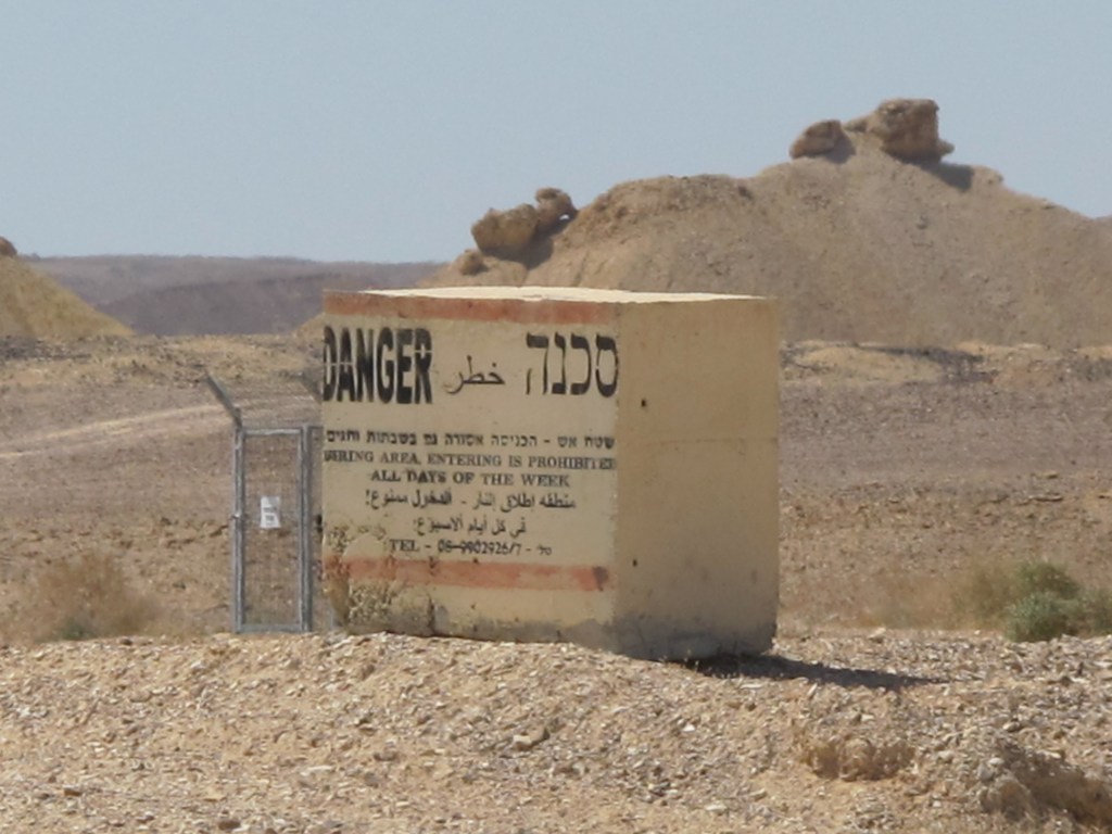
Warning Block as a signboard: “Danger: Firing zone, Entrance is Forbidden also in Saturdays and Holidays” alongside Highway 90, south Arava Desert. (Efrat Hildesheim, 2017).
However, the discussion of military signboards – even more than the discussion concerning other signboards – raises the question concerning the subject-traveler who is being addressed, while reflecting the dialectics of the borderoad: Who do the signboards address? Who are they intended to control, order, and regiment? Do they produce a hierarchy of addressees? Do all of the subjects in the borderoad space perceive and interpret the military-related signs in the same manner? Presumably, members of the military forces are not the main addressees of these signboards, since they are likely familiar with the terrain and with the location of the border and its military surveillance systems. In contrast to the traffic signboards managing the movement of travelers, the military signboards control and order the movement of all those living in, visiting, driving through or travel the borderoad landscape, subjecting them to the presence of the border.
The main significance of the warnings and threatening language on military signboards lies in their declaration concerning the border. Thus, the stand-alone sign “Stop! Border ahead” near the roadside (see chapter-cover image) does not only provide information or prevent transgressions of the border, but rather serves as a means of regimentation, a declaration of power over the territory. This is even more clearly expressed in the signboards warning of minefields, firing zones, or entering the Palestinian Authority. This practice exploits the ambiguity between the subtle and the explicit: whereas the instrumental function of the signboards is to prohibit travelers from approaching the border and to regiment the borderoadspace, their symbolic function involves constituting a border consciousness as well as demarcating territory. In this manner, military warning signboards operate cumulatively as ideological mechanisms assimilated into the other signboard arrays in the landscape, naturalizing their performance by becoming an integral part of it.
A dual, "Janus faced" perception of borders pertaining to their spatial/territorial characteristics (Kemp 2003), implies them to be ambivalent and blurred, yet strongly present in the collective national consciousness (van Houtum 2011). The military signboards exemplify this dialectics: they indicate the border as a line that must not be crossed, and the territory beyond it as that belonging to the “other.” Whereas signboards such as “Stop! Border ahead” accentuate territory, refer to the border-line, and distinguish between “interior” and “exterior,” the other military-related signboards (warning against minefields, approaching military checkpoint or firing zone) underscore the space. These strategies of blurring and ambivalence partake the practice of constructing national identity via the visual-spatial dimension of the borderoad: such, for instance, are the signboards warning against entering the Palestinian Authority in the West Bank mentioned earlier. These signboards mark the territory that is not under Israeli sovereignty (A and B zones), and thus imply that all the rest of the territory is (C zone), obscuring the fact that it is under the IDF civil administration and under political dispute. Similar ambiguity exists in the signboards warning against minefields, located in liminal areas – between fences, in the proximity of barbered wire, or close to the roadside. These signboards bespeak a dual perception of the border that is both territorial and spatial, and which is similarly part of an underlying landscape mechanism.

Warning signboards against entering the Palestinian Authority/A zone, Highway 90, West Bank / Jordan Valley. (Efrat Hildesheim, 2010).
The military warning and deterrence signboards form a landscape of an implicit linguistic violence along the borderoad: they do not merely report, inform or alert, but also threaten and warn in either an explicit or an inconspicuous manner, expressing the sovereign’s power of territorialization. Their uncompromising alluded or restrained violent language is an expression of a “regime of territorialization” (Wilson 2004). This becomes a landscape performance that attests to the importance of the border in relation to territory and sovereignty, and as such, attests to related practices: signboards function as a sovereign practice of control, a declaration of its exclusive status that underscores the principle of territorial continuity along the border. However, the practice of military-border signage operates in the sphere between precision and ambiguity. The encounter with them is a form of interpellation that catches the addressee unprepared, hence its source of power. The absent presence of the border becomes, in that moment, tangible and real. This encounter also relates to the consciousness of the subject. For non-Israelis, it merely manifests the military-civilian dialectics of the region; for Israelis, it also operates to enhance national identity in relation to the border, the territory, and therefore also the ideology of the state.
"Stop! Border ahead": discussion and summary
As noted, signboards operate as an installation of texts in the landscape. They are a landarrangement that undermines the picturesque illusion, reminding us that landscape is not wild nature, but rather the visual facet of a space that is administered, controlled and regimented. The signboards system underscores the heterotopic (Foucault 2003 [1984]) character of the garden, operating similarly in the borderoadspace. Like other landscape performances, the signboards are assimilated into the landscape, becoming part of its coded performance, using Mitchell’s words, "Looking at the view is like looking at the grammar of a sentence, while forgetting what it is saying" (Mitchell 2006, 587). Althusser’s notion of interpellative mechanisms and Billing's idea concerning banal nationalism have served to examine the arrangement of signboards in the landscape, which – as in the garden – operates to subject the traveler to the ideology of the sovereign.
The interdisciplinary discussion suggested in this paper intertwines the critical discourse on landscape with discourses concerning political and cultural geography, as well as the discourse on roads and highways. It presented a conceptual and critical discussion concerning landscape performance, and the concept of interpellation in the borderoad landscape of Highway 90, exploring the ways in which the system of roadside signboards operates as a mechanism by means of the everyday.
The signs providing information about the streams denoted the issue of place naming and were discussed as a practice of banal nationalism, which assimilates the local into the national. The idea of the urgent and 'hot' that merges with the banal was further demonstrated by the second and third theme. The system of signboards was then further examined as demarcating territory, seeking to create a territorial continuum, while underscoring the presence of the sovereign as the one administering, controlling and regimenting it. In this manner, an array of informative signboards serves to spatially enhance manifestations of the border, national ethoses and myths, and mythify the border itself, operating as an ideological agent and an interpellative mechanism. In the third theme, the military-related signboards and their dual spatial-territorial language of violence – either implied or explicit – give rise to the dialectics of the border. These dialectics also acts as a form of interpellation, and thus constitutes order, control, and border consciousness as part of an overall course in the landscape.
The paper suggests that the system of signboards ensures that the traveling subject recognizes the presence of the border and its proximity, even though the border itself is generally not visible. This recognition of the border joins the recognition of a range of myths related to the borderspace and to the military-civilian dialectics of the area. For Israelis, these are all tied to landscape performances constitutive of national consciousness: from the nationalist-territorial legacy of Ze’evi to the potash plant at Sodom, from kibbutzim near the country’s northern border or in the south Arava Desert to settlements in the Jordan Valley/West Bank.
The performance of the signboards in this landscape is revealed not only through the examination of types of signboards and the practices they enact, but also as a cumulative arrangement, a recurrent landscape performance. Serving to warn, deter, alert, threaten, direct, inform or denote the presence of places, directions, distances, minefields, military-related matters, or the border – these signboards are assimilated into the landscape in an incidental, almost transparent manner. They appear to be taken for granted and naturalized, and are received as part of the everyday landscape arrangement. The 'hot' and extreme character of their language and their banal, trivial character, are blurred into the landscape, so that their presence recedes as one progresses along the road. Thus, whether or not the travelers are Israelis, the interpellative course operates reluctantly without the travelers' awareness as “natural” – hence its effective power in the landscape.
* Main ideas of this paper draw on my Ph.D. thesis, which was written at the Azrieli School of Architecture, Tel Aviv University. I wish to thank Kenneth Helphand for his invaluable insights. An earlier version of this paper was published in Hebrew as "The spatial-politics of road-signs and signboards in a borderoad landscape: the case of road 90," Horizons in Geography 2019 (97), pp. 6-28.
References
ALTHUSSER, Louis (1971), "Ideology, and Ideological State Apparatuses (Notes towards an Investigation)", Lenin and Philosophy and Other Essays. London: New Left Books.
AMMORE, Louise (2006), "Biometric borders: Governing mobilities in the war on terror", Political Geography 25(3), pp. 336-351.
APPADURAI, Arjun (1996), Modernity at Large: Cultural Dimensions of Globalizations, Minneapolis: University of Minnesota Press.
AZARYAHU, Maoz, and Kook, Rebecca (2002), "Mapping the nation: street names and Arab-Palestinian identity: three case studies", Nations and Nationalism, 8, 195-213.
AZULAY Ariela and Ofir Adi (2007), "Separation, subordination and violence", Theory and Criticism 31 (In Hebrew), pp. 155-172.
BEN-RAFAEL Eliezer, Shohamy Elana, Amara Muhammad Hasan and Trumper-Hecht Nira (2006), "Linguistic Landscape as Symbolic Construction of the Public Space: The Case of Israel", International Journal of Multilingualism, 3:1, pp. 7-30, DOI: 10.1080/14790710608668383
BENVINISHTI Meron, (1997), "The Hebrew map", Theory and Criticism 11, pp. 7-29. (In Hebrew).
BERG, Lawrenve, and Vuolteenaho, Jani (2009), (eds). Critical Toponymies: The Contested Politics of Place Naming. Aldershot: Ashgate.
BIGON, Liora and Dahamshe, Amer (2014), "An anatomy of symbolic power: Israel road-sign and the Palestinian minority", Environment and Planning D: Society and Space, 32(4), 606-621.
BILLING, Michael (1995), Banal Nationalism. London: SAGE.
BRAMBILLA, Chiara (2015), "Exploring the critical potential of the borderscapes concept", Geopolitics, 20(1), pp. 14-34.
BRAMBILLA, Chiara, Laine, Jussi, Scott, James W., Bocchi Gianluca (2016), Borderscaping: Imaginations and Practices of Border Making. Surrey: Ashgate
BROWN, Wendy (2010), Walled States, Waning Sovereignty. New York: Zone Books
COHEN, Saul. and Kliot, Nurit (1992), "Place-names in Israel ideological struggle over the administered territories", Annals of the Association of American Geographers 82(4), pp. 653-680.
DAHAMSHE Amer and Schwartz Yossef (2018), Place names and spatial identity in Israel-Palestine: majority-minority relations, oblivion and memory (In Hebrew), Tel Aviv: Resling
DELL'ANGESE, Elena, and Amilhat Szary, Anne-Laure (2015), "Borderscapes: From border landscapes to border aesthetics", Geopolitics, 20(1), pp. 4-13.
EDENSOR, Tim (2003), "Defamiliarizing the mundane roadscape", Space and Culture, 6(2), pp. 151-168.
EDENSOR, Tim (2004), "Automobility and national identity", Theory, Culture & Society, 21(4-5), pp. 101-120
ELDEN, Stuart (2007), "Governmentality, calculation, territory", Environment and Planning D: Society and Space, 25(3), pp. 562-580.
ELDEN, Stuart (2010), "Land, terrain, territory", Progress in Human Geography, 34(6), pp. 799-817.
FOULCAULT, Michel (1966), Les Mots et les Choses. Paris: Edition Gallimard, 137-176.
FOULCAULT, Michel (2007), Security, Territory, Population. Lectures at the Colle`ge de France 1977-78. Hampshire: Palgrave Macmillan.
HANDEL, Ariel (2007), "Space control through space: Uncertainty as a control technology", Theory and Criticism 31 (In Hebrew), pp. 101-126.
HANDEL, Ariel (2017), “Distance Matters: Mobilities and the Politics of Distance”, Mobilities 13 (4), pp. 1–15. doi:10.1080/17450101.2017.1394681.
HILDESHEIM, Efrat (2020), "Landscape syncope: desire, power and the presence–absence of landscape", Culture, Theory and Critique, 61(4), pp. 404-423, DOI: 10.1080/14735784.2021.1912621
HILDESHEIM Efrat (2022), "Landscape and National Modernism in Israel's Highway 90: The Case of the Northwest Dead Sea Segment, 1967-1971", Studies in the History of Gardens & Designed Landscapes, DOI 10.1080/14601176.2021.2005351.
HOCHBERG, Gil (2015), Visual Occupation. Durham and London: Duke University Press.
ISRAEL STATE ARCHIVE ISA-NetiveiIsrael-NetiveiIsrael-000jf0d
JONES, Rhys (2012), Border walls, security and the war on terror in the United States, India and Israel. London/New York: Zed Books
JONES, Rhys, and Merriman, Peter (2009), "Hot, banal and everyday nationalism: Bilingual road signs in wales", Political Geography, 28(3), pp. 164-173.
JONES, Reece. and Johnson, Corey (2014), Placing the Border in Everyday Life. Surrey/Burlington: Ashgate.
KEMP, Adriana (2003), "The border as Janus's face: space and national consciousness in Israel", In Yeoda Shenhav (ed.) Space, Land, Home. (In Hebrew). Tel Aviv: Van Leen Jerusalem Institute/Hakibbutz Hameuchad Publishing House.
KIMMERLING, Baruch (1983), Zionism and Territory: The Socio-Territorial Dimension of Zionist Politics. Berkeley: Institute of International Studies, University of California.
KOSOLOV, Vladimir and Scott, James W. (2013), Euroborderscape: Working paper 4: Selected conceptual issues in border studies. http://www.euborderscapes.eu
LEFEBVRE, Henri (1991[1947]), The Production of Space. Oxford, UK: Blackwell Publishing.
MERRIMAN, Peter (2007), Driving Spaces. Oxford: Blackwell Publishing.
MERRIMAN, Peter, and Jones, Rhys (2009), "Symbols of justice’: The Welsh language society's campaign for bilingual road signs in wales, 1967–1980", Journal of Historical Geography, 35(2), pp. 350-375.
MINCA, Claudio. and Rijke, Alexandra (2017), "Walls! Walls! Walls!", Society and Space https://societyandspace.org/2017/04/18/walls-walls-walls/
MITCHELL, W. J. T. (2002a), "Imperial Landscape". In William J. T. Mitchell (ed.), Landscape and Power. Second edition. Chicago and London: University of Chicago Press, pp. 5–34.
MITCHELL, W. J. T. (2002b), Landscape and Power. Chicago: The University of Chicago Press.
MITCHELL, W. J. T. (2002b), Introduction'. In William J. T. Mitchell (ed.), Landscape and Power. Second edition. Chicago and London: University of Chicago Press. Pp. 1-4.
MITCHELL, W. J. T. (2006), "Christo’s Gates and Gilo’s Wall", Critical Inquiry 32 (4), pp. 587–600. https://doi.org/10.1086/508081
NASH, Catherine (1999), "Irish place names: post-colonial locations". Transactions of the Institute of British Geographers, 24, pp. 457-480.
PAASI, Anssi. (2003), "Region and place: Regional identity in question", Progress in Human Geography, 27(4), pp. 475-485.
PAASI, Anssi (2010), "Regions are social constructs, but who or what 'constructs' them? agency in question", Environment & Planning A, 42(10), 2296-2301.
RAJARAM, Kumar Prem and Grundy-Warr, Carl (Eds) (2007), Borderscapes: Hidden Geographies and Politics at Territories' Edge. Minneapolis: University of Minnesota Press.
ROSE-REDWOOD, Reuben, Adelrman Derek. and Azaryahu, Maoz (2010), "Geographies of toponymic inscription: new directions in critical place-names studies", Progress in Human Geographies 30 (4), pp. 468-486.
RUMLEY, Dennis, and Minghi, Julian V. (Eds) (1991), The Geography of Border Landscape. London and New York: Routledge.
SCHIMANSKI, John and Wolfe, Stephen F. (2017). Border Aesthetics: Concepts and Intersections. New York, NY: Berghahn Books.
SOPHER, David E (1979), "The landscape of home: Myth, experience, social meaning", in Donald Meinig (Ed.) (1979), The Interpretation of Ordinary Landscape. New York: Oxford University Press.
STRUVER, Anke (2005). Stories of the 'Boring Borders': The Dutch-German Borderscapes in People's Mind. Munster: LIT.
SOHN, Christophe (2015), Euborderscapes Working paper 10: On borders’ multiplicity: A perspective from assemblage theory. http://www.euborderscapes.eu/
VALLET, Elisabeth (ed.) (2014), Borders Fences and Walls: State of Insecurity?. Surrey/Burlington: Ashgate.
VALLET, Elisabeth. and David Charles-Philip (2012), "Introduction: the (re)building of the wall in international relations", Journal of Borderland Studies 27(2), pp. 111-119
VAN HOUTUM, Henk (2005), "The geopolitics of borders and boundaries", Geopolitics, 10, 672-679.
VAN HOUTUM, Henk (2011), "The mask of the border", In D. Wastl-Walter (Ed.), The Ashgate Research Companion to Border Studies. Surrey: Ashgate, pp. 49-62
VIRILIO, Paul (2006), Speed and Politics. New York: Semiotext(e).
WEIZMAN, Eyal (2007), Hollow Land: Israel's Architecture of Occupation, New York: Verso.
WEIZMAN, Eyal, and Segal, Rafi (2003), The battle for the hilltops. In Eyal. Weizman, and Rafi Segal (Eds), Civilian Occupation: The Politics of Israeli Architecture. New York: Verso, pp.79-108.
WILSON, Fiona (2004a), "Towards a political economy of roads: Experiences from Peru", Development and Change, 35(3), pp. 525-546.
YUVAL-DAVIS, Nira (2013), Euborderscapes Working Paper 2: A Situated Intersectional Everyday Approach to the Study of Bordering. http://www.euborderscapes.eu/
http://zemer.nli.org.il/song/Bait_Lazemer003822168
[1] See, for instance, Foucault’s discussion of classification (Foucault 1966, 137-176).
[2] Italics and apostrophes appear in the original text.
[3] This segment was singled out as part of the Israeli-Jordanian peace treaty signed in 1994, and is awaiting a trilateral agreement – between Israel, Jordan and the Palestinian Authority – that has yet to come. see Srebro 2014.
[4] The ceasefire line, also known as the Purple Line, was unilaterally effaced as a borderline by the State of Israel following Israel’s annexation of the Golan Heights in 1981. This segment of the highway, running from Metula south to Ashdot Yaakov, is about 83 km. long.
[5] Some of its segments are evidently visible in the Tabula Peutingeriana – a map describing the road network of the Roman Empire.
[6] This means that Israel has never officially annexed the occupied territories of the West Bank, which are administered by the army, while parts of these territories (Zone A, B) are mainly administered by the Palestinian Authority.
[7] The notion “borderscape” is associated with Arjun Appadurai’s (1996) discussion of the notion of “scapes.” It pertains to the relations between the border and its geographical surroundings (Rumley and Minghi 1991), to the geopolitical complexity of border zones (Rajaram and Grundy-Warr 2007), and to the context of European borders (Yuval-Davis 2013; Kolossov and Scott 2013; Sohn 2015). This concept is also used in the discussion of border aesthetics (Schimanski and Wolf 2017) in post-phenomenological, Deleuzian perceptions (Brambilla 2015; Brambilla et al. 2016), and in relation to imagined borders (Struver 2005) and landscapes (dell'Agnese and Amilhat-Szary 2015).
[8] The scope of this paper does not allow for an extensive discussion of toponomy, and specifically of the manner in which the Israeli-Palestinian conflict is given expression in the linguistic landscape on signboards and road signs. For a comprehensive survey of this subject, see the discussions in Benvenisti 1997; Ben-Rafael et al. 2006; Dahamshe and Schwartz 2018; Bigon and Dahamshe 2014, which attend to the strategies of naming and effacing the Arabic language as a widespread hegemonic practice.
[9] In a similar case in Israel, the political character of road signage, and the occlusion of this political dimension by the state, are similarly revealed by the 1997 petition submitted to the High Court of Justice by the Israeli-Arab human-rights organization Adalah. The petition demanded to include the Arab language – an official minority language in Israel – on highway road signs. In response to the appeal, the State argued that an addition of a third language (to the bilingual Hebrew and English roadsigns) would create confusion and provide excess information – the same argument used in the Welsh case. The Court ordered the State to use tri-lingual signs. As argued by Merriman and Jones, here too the political and ideological charge of signage arises in the everyday context, and the sovereigns' argument demonstrates its power to use language as an interpellative tool.
[10] The borderoadscape includes numerous sites that function as national landmarks – some recognized as national parks or heritage sites, and others associated with a religious, national or historical context – for instance, Masada, the worker’s camp at Sodom, Kevutzat Kineret (one of Israel's first collective agricultural settlements) and the tomb of the poet Rahel, as well as the tomb of Rabbi Meir Baal Haness.
[11] Italics appears in the original text.
[12] Signboards alongside roads and highways are positioned only with the permission of regional council or Netivei Israel – National Transport Infrastructure Company (previously PWD).
[13] Other signboards indicating hiking routes alongside streams are located at sites where it is convenient to exit the road. These signs – indicating the name of the stream and its color coding as it appears on hiking maps – are in the form of a rectangle ending in an arrow, which designates the point of access to the stream. These are located adjacent to parking areas, usually placed by the Israel Nature and Parks Authority.
[14] The practice of placing signboards bearing names of streams on roadsides appears throughout Israel and elsewhere in the world. Nevertheless, their presence is conspicuous along the West Bank segment due to the scarcity of settlements and advertising billboards (which are prohibited by law) along the highway.
[15] The English spelling of place names on Israeli road signboards often involves variations which do not accord with international spelling conventions, as made evident on several of the signs in the accompanying images.
[16] On the border as site of mythification in Israeli society see Kemp 2003.
[17] “The Red Rock” was the popular name for Petra in Israel in the 1950s–1970s, as well as the name of a ballad released in 1958, which glorifies the journey to the fabled city. The song was prohibited from being broadcast on public radio for many years, for fear that it would encourage young people to set out on the forbidden journey to Jordan. The song is available online at http://zemer.nli.org.il/song/Bait_Lazemer003822168
[18] In the West bank, from the intersection with Road No. 1 on its southern part near Jericho to the the Bezeq/Mehule checkpoint in the northern part of the Jordan Valley, on the Green Line (the 1949 armistice agreement line). The name 'Gandi's road' here corresponded with its spelling on the signboards on Highway 90.
[19] Source: Israel State archive ISA-NetiveiIsrael-NetiveiIsrael-000jf0d
[20] The “firing zone” designation is a practice which is often claimed to be an administrative means of holding land and carry out political decisions related to Palestinians and Bedouins. See https://www.keremnavot.org/a-locked-garden.
